Continuing our honeymoon, Val and I spent a couple of fabulous days in Boise after backpacking the Teton Crest Trail. Our original plan was to hit the trail again on Sunday for a 5 or 6 day loop in the Sawtooth Wilderness, but after dealing with rain for 5 days, we decided to take an extra day and shorten the trip. That changed our trailhead as well so Sunday we drove around the wilderness to Stanley, ID were we stayed the night. That night we checked weather forecast and packed our gear for an early departure the following morning. The forecast was not very promising but we still opted for following the plan and hitting the trail.
Day 1: Pettit Lake to Twin Lakes
After a quick breakfast in Stanley, we drove the ten or so miles to the trailhead and got on the trail in no time. The morning was spectacular and very promising with clear blue skies and warm temperatures. At first the trail took us on the north side of Pettit Lake all the way to the end were, after passing a small meadow, left the valley behind and started climbing towards Alice Lake. It didn’t take long for us to leave the lake behind and start traversing a canyon with huge granite walls on both sides. It almost seemed like every other step, the scenery was different and we had traveled a long distance when in reality it was just a different perspective. The trail follows a creek most of the way that in most places you can only hear. After several turns and crossing a very shallow creek we finally got to the first lakelet below Alice Lake. In front of us was a cirque of tall peaks and incredible scenery.

For a while we walked around the north side of Alice Lake enjoying the views of towering El Capitan (not to be confused with the California Version) on the other side. WE left this scenery only for a moment to climb just a bit more and then descend towards our destination. We arrived at Twin Lakes right to the stretch of land that separates them. Just by instinct and because that was the way we would follow the next day, we turned right and continued north on the shore of upper Twin Lake until we found a campsite. We dropped our backpacks and went checking for other sites but didn’t find any. It was still pretty early in the afternoon so we set up the tent and relaxed a bit. I got in the water for a while and stayed there for as long as my legs were able to comfortably take the cold water. After that, I went exploring a bit, first back towards lower Twin Lake. I walked pass the junction we had arrive from and decided to explore a bit around the stretch that separates the lakes. In that area I found the best campsite. It had big fire pit and views to both lakes. We had already set up so moving was not an easy option. On my way back, I passed or campsite and continued on the trail we would take the following day towards the north end of the lake. The trail starts climbing quickly on that side so that extra elevation gave a really good angle and view of the lake. I took a couple of pictures but made a mental note to go later in the afternoon to get some nice light and take more pictures. We had a nice dinner that night and after putting everything away and hanging the food, I went back to the north end to sit and take some pictures. By then, he sky was already graying out a bit. There was no rain yet but it wasn’t looking very promising.

The next morning we woke up to a very grey and almost cold morning. We guessed we got some drops of rain thru the night but nothing like we had in the Tetons. Still, the clouds and sky were corroborating what the forecast said. The original plan for the day was to go over the pass towards Toxaway Lake and then continue north towards Kramer Lakes or west towards Edna Lake. Either of these routes included going over passes or hiking on ridgelines. With bad weather, that didn’t seem like a very good idea. So we started our hike going north passing by the spot I had gotten to take pictures the previous night. From there, the trail just traversed the hill on a couple of very long switchbacks until we got to the saddle.
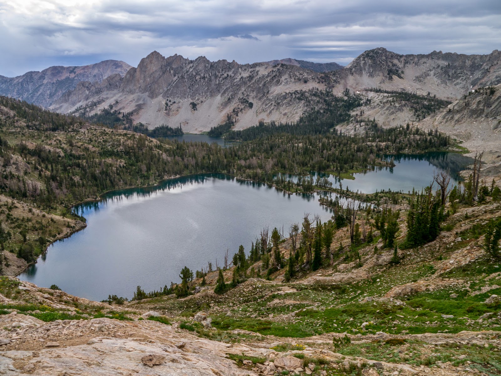
At that point we got our last view back at Twin Lakes which, at that elevation looked just fantastic. From there we stared descending quickly towards Toxaway Lake. On the way we passed a couple of very shallow lakelets filled with turquoise water. Above us, the clouds still looked very menacing. This chain of lakelets was connected by a creek that moved water from the ridge down to the lake. So the trail continued traversing the hills close to it. The final approach to Toxaway was a series of switchbacks on the right side of a huge rock filed were you could see numerous waterfalls. Going around Toxaway was not very interesting as view of the lake were limited. That was until we got to the north side. The lake itself is beautiful especially because of a small island in the middle. About half way on the north side, we found the trail junction going up to the saddle around Sand Mountain. By then the sky was not showing signs of improving so we called it and decided to continue down towards the car rather than risk it and go over the pass. From there to the next lake, Farley Lake, the trail took us by several small lakes and ponds.

I recall one in particular that might have been no more that 10 or 12 feet in diameter but very deep. It almost looked like a small crater filled with water or a sink hole. While passing by Farley Lake, the sky cleared up a bit and it almost seemed that it was going to hold but that didn’t last long. By then we were already descending towards the forest as the clouds were quickly moving in. We kept on hiking trying to maintain a good pace as we knew the rain was coming. We could even smell it in the air. The wind picked up and then the first clear sign, thunder. At first it was far away but as we continued, they seemed to be getting closer and closer. We got our rain gear out and put it on when it started raining, lightly at first but getting worse by the minute. When we passed the lowest point of the connector trail that would take us back to the trailhead, the sky was incredibly dark and the sound of thunder was almost nonstop. We pushed on. Right after passing the last ridge line, where we knew it was all downhill from there, we got the think of it. At first it was pouring rain with wind, lighting and thunder, but then it started hailing. Finally we saw the shore and we knew we would be out quickly; we just needed to hike around the north side of the lake to the parking lot. As we did, I looked back to a complete different image of the lake than the image we saw the day before. From our point of view, we couldn’t see the other shore much less the towering peaks on the other side. Not only that but we also so waves on the lake.

It almost looked like we were on an ocean coast. We finally made it to the car just when the rain stopped so we had a chance to put our gear away, dry up, change and start driving. The dry spell didn’t last long and we got more of the storm while on the road. As we drove away from the Sawtooth we couldn’t believe the clouds around us. We knew then it had been a good call to bail. We got a nice glimpse at this magnificent area that we’ll certainly visit again sometime, hopefully with better weather.
Interactive map
To see the full map, click Menu and select Full Screen. You can also click Terrain to change the map style


No comments:
Post a Comment