Dry Creek Falls, Jul 4th

texAfter the long hike on Friday, I though a short hike in the afternoon would be a great plan; even better if it included water so I could take Shia with me. Looking at the many options in the Gorge, Dry Creek Falls caught my attention as it seemed to be a seldom visited waterfall just two miles in from the parking lot. Dry creek is close to the Bridge of the Gods and accessible thru the PCT. It’s seldom visited because you have to go out of your way to get there. What I wasn’t expecting was a very hot afternoon though. Either way, we met and drove to a parking lot just before Bridge of the Gods where the PCT takes of in the Oregon Side. After passing under highway 84 and quickly ascending to the power lines, the trail starts meandering thru the forest with very little elevation change. After about one hour, we got to the creek where we made a quick stop to take pictures and let the dogs get in the water. From there, you have the option to continue on the PCT on your way to Mexico or take a small detour to the waterfall. The waterfall itself is kind of hidden so you barely see it until you’re in front of it. Still it is a beautiful fall plunging more than 100’ between some huge basalt formations. We stayed for a while at the waterfall while some of the hikers in the group went for a “shower”. After that we hiked our way back to the cars.

Three Corner Rock via Stebbins Creek, Jul 3rd

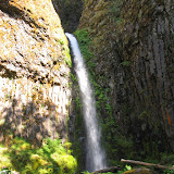
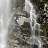
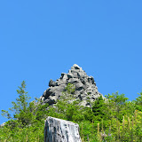
With a long weekend ahead of us, it was time for us to plan a long hike, that way, if we were in too much pain; we still had two days to rest after that. For this I had a couple of options with similar distances and elevation gain so I opted for Three Corner Rock in the Yacolt Burn State Forest in Washington. This peak has a three or four different approaches. One of them is short and not that difficult, two coming in from either side of the PCT and the approach from Stebbins Creek. To me, the Stebbins Creek looked like a better choice but that involved a hike of about 18 miles to get to the summit. So we met on a very hot Friday morning to drive to the trail head taking two cars. In the process we lost one so the group got initially divided. Once there, and after waiting for a couple of minutes, we decided to head out and maybe regroup later. The trail started with a short climb going around a small butte towards Stebbins Creek. Once we passed the butte, the trail continued on a steady ascend close to the creek until we got to some big rock formations. From that point, the trail was all switchbacks gaining a lot of elevation until we were high enough to pass a small creek. On the other side we had roughly the same amount of switchbacks going back down. By that time we had seen a couple of clearings were we could see Three Corner Rock in the distance. It was funny that in one of those turns, there was actually a sign that read “In the Distance”. The trail continued through a dense fern forest with some clearings. By the time we got to the point were we needed to cross Stebbins Creek it was already very hot so we took a long rest and just when we were about to continue, Greg (from the car we lost) arrived. The rest of the group was 10 to 15 minutes behind him so we decided to wait a little more to regroup. Once Chris, Valarie and Carol got to the creek, we continued through some more forest and steadily climbing until we got to a forest road that provides access to the easy hike. After crossing the road, the trail changed to a more open set of switchbacks with lower vegetation which made the last couple of miles to the top a daunting task. With the clear sky and full sun, we were literally cooking ourselves on our way to the summit. Once there though, after the short scramble on the rocks to get to the very top, besides being welcomed with sweeping 360 degree views, we had a nice, cool breeze. After a well deserved lunch and enjoying the sun and views, we started our way back down on the same trail. In the end we were very tired but the sense of accomplishment was great. Hiking for about 10 hours to cover 18 miles is not a walk in the park, but is definitely doable!

Backpacking at Soda Peak Lake, Jun 27th

In preparation for our upcoming five day backpacking trip to the Enchantments with Gordon, we decided to do a short, one night backpack to Soda Peak. The reason, besides just getting out and camping in a beautiful lake, was to see how we felt hiking up about 3.5 miles with a similar elevation as what we will find in Aasgard Pass. I did this hike back in 2007 and remembered from back then that it was a steady climb to the lake. What I was not counting on was a very hot summer day. Soda Peaks is a small lake in the Trapper Creek Wilderness in Washington surrounded by mountain ridges and a nice opening towards Mt Adams. A couple of days before the trip, Gordon told me he was going to hike up o Friday and stay two nights, so on Saturday morning, it was only Lily, David and me plus Shia and Kodi. Once at the trail head, we started our hike up passing a private road that gives access to numerous cabins along the creek. We met a couple of people on the way before getting to the actual trail and the only reason for mentioning it here is that one of them started giving us directions in a complete different way than what we had planned. Not only he was arguing that he’d lives in the area for over 30 years but also that he new the trail like the back of his hand. I guess it was good not to pay a lot of attention because he was wrong as we found out shortly after we hit the trail. Gordon had gone the week before to scout the area and found a downed tree in front of the creek that obscured the trail. Without a map, you would guess that you had to cross the creek and continue on the other side but there was no trail. The trail was actually on the same side of the creek just behind the tree. From there we continued on a beautiful green forest to a higher point on the creek where we crossed and started the hard part of the ascend. Knowing it wasn’t a very long hike and that we had the rest of the day, we took our time and made various stops to cool off until we finally made it to the lake. After resting for a bit we setup camp and helped Lily with all her new gear. Later that afternoon we went for a walk around the lake exploring the other campsites and the many views. On Sunday, after a nice breakfast, Gordon took us on a hike to the top of the ridge that offers views of the lake down bellow, the valley and Mt Adams in the distance. We stayed at the view point for quite a while until the wind started to make us feel a bit cold. Once back down at the lake, it was time for the dogs to go swimming. Despite all the efforts, Shia was the only one that actually went for a swim. I guess Kira and Kodi haven’t discovered that pleasure yet. We then took our time packing and getting ready to leave on a very hot afternoon. As with the hike up, we took our time to rest and cool down especially when we got back to the creek. As you’ll see in the pictures, Shia appreciated that a lot. Definitely a short trip, but spending the time with a small group, in a beautiful and almost remote lake and talking about gear was very well worth it.

Shelburg Falls, Jun 21st

This weekend I wasn’t able to plan an epic hike to somewhere really difficult, exotic or strenuous. Part of it was because I was just returning from a work trip so I was pretty tired. Still, I needed some outdoor time so I chose the Shelburg Falls loop as it wasn’t that long or steep. Furthermore, the book I took the info from mentioned it was a great trail for cloudy weather that matched what the forecast said. This loop is very close to the very well known Silver Falls State Park. Perhaps that’s why I didn’t see a lot of people on the trail. Also, a good portion of this loop is on a private forest road which is not that interesting. The hike starts with a soft climb on the road towards the Lower Shelburg Falls which, if you don’t make a little detour, you don’t get to see. Basically the road goes over the creek with the fall on the right side of the road while the trail starts on the other side. I saw some rocks that gave me access to a lower view which was much better but still limited. On the other side of the creek I could see a possible way to descend a bit further so I tried that just to get a better picture. To make the long story short, it was very loose ground so I slipped and fell and rolled and landed at the base of the fall, fortunately unharmed and unscratched. I did get the pictures though. From there I started on the trail that goes through a dense forested area before getting to the highlight waterfall of the hike, Shelburg Falls. This waterfall, although it doesn’t have a lot of water is set in a spectacular rock formation that surrounds the base. The trail the goes behind the waterfall and comes on the other side just to continue towards the Shelburg Campground. From that point on the trail is just a walk in the forest on a far less visited trail with lots of flowers and Salmon Berries. Eventually you get back to the access road from where you can just walk out but looking at the map I noticed there was a third waterfall that required a small deviation. An almost invisible trail took me to the top of Stasel Falls which I found to be more interesting than Shelburg. Only problem is that I was at the very top of it and it didn’t seem to be a good way to get a descent look. After wondering around a bit, I decided to scramble and bushwhack my way down to the base of the waterfall. I’m glad I did as I was able to get to the very base of it just in time to take some pictures with the only sunshine I got the whole day. Stasel Fall, as you’ll see in the pictures, is a two stage waterfall that first dumps the water in a small pool before jumping out again to the lower section. I’m not sure if it was the angle or what but I was able to stand right in front of it without getting wet so I stayed there for a while enjoying the view and having a light snack before heading back. I guess it was just my luck that rain started a couple of minutes after I got in my car.