Tom, Dick and Harry, Oct 27th

Tom, Dick and Harry located along hwy26 is one of those short nice hikes in Oregon that’s in the must visit list. If for nothing else, getting to Mirror Lake is just a stroll in the forest with great rewards. Once you get to the lake, you can circle it and enjoy the reflections of Mt Hood in its waters… that of course, requires a nice, clear, blue sky day which we didn’t have. But even with the overcast day we had, we had our treat as we hiked in the first snow of the season around the lake. From there, we continued up towards the summit. As temperature was not cold enough to keep the snow from melting, the whole trail was a small creek making it hard to go without drenching your boots. My original plan was to get to the summit, have lunch up there and then spend some time exploring the ridge but weather had other plans. Once we got out of the cover of the forest, we got rain, wind and snow to the point that we got there, took a picture and came back down just making a quick stop at the junction with the Mirror Lake trail, under a tree, to grab a quick bite and continue to the cars. At least we got a decent workout right?


Interactive map

To see the full map, click Menu and select Full Screen. You can also click Terrain to change the map style

Yocum Ridge, Oct 6th

Scratched another one from the to-do list. This hike has been in my radar for quite some time but for reasons unknown to me, it was put in the backburner and never revisited. I guess it had to do with a previous hike long time ago where I think we did try to get there but whoever was leading didn’t find the way and we ended up in a section of the PCT that was washed out. So this time I gathered a bit more info and headed out with a small group of very fast hikers. We started from the Ramona Falls trailhead and quickly reached the Sandy River to cross on the seasonal bridge. It was a gorgeous day. From the two options to reach Ramona Fall, we took the northern trail that travels parallel to a small creek and some interesting rock walls that are part of the side of Yocum Ridge. This first section was quick and beautiful. When we reached the PCT, we needed to turn left to continue towards Yocum Ridge but instead we went to Ramona Falls to take a short break and then backtrack. I’ve got to say that this is still, in my opinion, one of the most beautiful waterfalls in the region. After a quick bite=, we took off continuing on the PCT towards the Yocum Ridge intersection. In current maps, this trail is still part of the PCT although some parts have been decommissioned due to the washout I mentioned before. But before we even got there, we found the fork to the trail we needed to take. And the climbing began. It was an arduous trail going pretty much in a straight line up traversing the side of a forested hill. We passed a couple of turns where you can get limited views of the Sandy thru the trees. The trail didn’t offer much for quite a while but then it actually started flattening out. Towards the top of Yocum Ridge, there’s a big meadow you traverse en route to the end of the trail and the Yocum Ridge viewpoint. Even though we had gain most of the elevation for this hike, the views where still obscured by trees for a while but eventually the summit started showing big and bold right up ahead. The scenery was beautiful, a grassy meadow crossed by a trail, trees here and there and the looming rocks and glaciers ahead. A couple more turns and a last push took us to the end of the trail and a steep drop-off to the Sandy. Besides having an ample view of the river’s origin, we had a full view of the Reid Glacier and the top of the mountain. It was a perfect spot for lunch and a bit of sun bathing. From there, we hiked back to the PCT the same way we came up all the way to Ramona Falls for a third short stop. Then we continued on the southern trail to Ramona Falls which now if part of the PCT all the way to the bridge, the Sandy River and the parking lot.


Interactive map

To see the full map, click Menu and select Full Screen. You can also click Terrain to change the map style

Horseshoe Ridge – Cast Creek loop, Sep 29th

This is the classic example on how much a trail can change… well, not the actual trail but the access road changing the hike entirely. In Mt Hood there are several trails that can be joined to form a loop. Some of those require hiking on a road for a bit to connect them. About three years ago I did this loop clockwise and learned the route I tried this time. On that occasion, we drove on Forest road 380 to the Cast Creek trailhead, did the entire loop and then, once we got back to road 380, we hiked back the little over a mile distance to the parked cars. This time I wanted to revisit that hike as I remembered the views and the hike itself being fantastic. I also wanted to do it in reverse, starting from Horseshoe Ridge and coming back on Cast Creek so we would do the road first. So we drove there and the first surprise we got was that road 380 has been decommissioned. We were not even able to get to the Cast Creek trailhead (the one I remembered). Without knowing anything else, I assumed there was only a big road block and that if we just went over it, we would find the road on the other side. Well we did, but the road was destroyed. Not only they had gone in with heavy machinery and dug big holes so not even a big foot truck could pass but they took all the bridges and even pulled some trees in the middle. The whole thing ended up being a 2 miles, hardcore bushwhack. Luckily we did this first as I could not imagine how it would have gone if we had to do it after completing the loop. In any case, on those two miles we had to descend and climb back out of three creeks, go over boulders, trees and branches. Eventually we made it to the old Horseshoe Ridge trailhead. From there I saw what originally was a second option to access this route from Riley camp. I guess now is the only way to do it. We stopped for just a minute to get our breaths and then started hiking up on a real trail. For a while the hike was in dense forest without a lot of views, but eventually it comes out to a wonderful open meadow that overlooks Lolo Pass road. On good days you can see Adams and Helens from there but not Hood behind you. A bit more climbing finally took us to the Zigzag trail and the view I was hoping for. Hiking in this area is just extraordinary. We followed the Zigzag ridge and made a stop for lunch at one of the prominent points with front row view of Mt Hood. From there we connected with the Burnt Lake trail and then Cast Creek to hike back down on another section of the dense forest. So now we know, with forest road 380 gone, this loop is now longer.


Interactive map

To see the full map, click Menu and select Full Screen. You can also click Terrain to change the map style

Arikok National Park - Boca Prins to Conchi, Aruba, Sep 20th

Although most people that go to Aruba go there to enjoy the sun, the beach, the year-round mild weather, the food and even gambling, there are also other things worth visiting. One of those is the Arikok National Park. This park is located in the north-east side of the island facing the rough Atlantic Ocean. Perhaps that’s reason enough why this side of the island is not as prone to tourism as the milder Caribbean south-west side. Still, this park offers more than just a couple of things to explore. The park itself covers about 34 square kilometers which is roughly 20% of the islands size. Considering that Aruba is roughly the size of Michigan, this is a considerable sized park. Among other things, you can take guided tours in the park to explore its flora and fauna or you could take a tour to the natural pool. For more adventurous souls, you can just wander around and walk in completely unmarked paths and trails in any direction you want. One thing to keep in mind for this is PLENTY OF WATER. Not only the park is hot without a lot of shades areas but there have been cases where the authorities have had to go pick up unprepared people. Besides all the above, the park is remote enough that, even after being in Aruba more than a couple of times, I didn’t even know it was there. I guess that’s what maps are for. So after spending 4 or 5 days in the beach with Val, we were ready to do something different and what better place than this to go on a hike. With a small rented car we drove and drove and finally got to the entrance of the park where we were greeted by a friendly guard that couldn’t tell us if the park was open or not. In the end we learned that the governor was having a party in the main building but we were able to get tickets and continue on our way. From there on the drive was long and tedious. Don’t get me wrong, the road is good but every hundred or so yards there are ruts to probably divert water deep enough to make any compact car bottom out. After a while we finally made it to Boca Prins and parked in front of the only building in the area, a very desolated restaurant that, at that time, we didn’t know if it would open or if it was abandoned. Then we started walking. At first we found a very nicely marked path going towards the coast. For a moment we thought the park was very well developed, but shortly after, once we got to the staircase that climbs down to the Boca Prins, that was it. From that point on the trail was barely marked with 4x4 that looked exactly like washout logs from the sea. It wasn’t much of a problem though; having a huge ocean on the side makes it real easy to navigate. As we hiked north, we noted the terrain was incredible rough. It felt like solid rock that has been eaten up by the constant hit of the waves. Erosion at its best. As you can imagine, the views were fantastic although not changing much. On one side we had dry arid land with several goats eating anything that looked barely green, some white patches of sand and the multiple shades of blue of the ocean. Watching the waves hit the shore repeatedly was almost hypnotizing. Eventually we lost the trail, more than a couple of times but we continued along. At a point we saw some white deposits on the rocks that ended up being raw sea salt in big crystals. The terrain made our pace slower than what Val and I normally do but in the end we got to the parking lot at Conchi where you can descend to the natural pool. We still had plenty of water but it was a very hot day. Luckily for us, we found a guy in a pickup truck selling or sorts of drinks and snorkeling gear. A few Gatorades and some lunch later we decided to head back roughly the same way we came and not follow our original plan of a big lop that would have lasted more than a day. Coming back was equally impressive as going out although being early in the afternoon, it got extremely hot to the point that we both had to stop and hunch down under a tree to recover a bit. After a short break we decided to just push for the car and go get something to drink but were pleasantly surprised to find the restaurant opened. Without thinking too much, we went in and sat down for a nice lunch and cold drinks which brought all the energy back. We knew that there were some caves nearby so having still some time, we got in our little car and drove south to Guadirikiri Cave. At first we thought it would be a tiny cave not offering much but as soon as we walked in we were wowed by the space and beauty. The cave has several skylights that open to the blue sky and allow you to walk without a flash light. We visited several rooms in the cave admiring the different shades of yellow, orange, green and even blue. It was a magical place. After that we tried to visit the Fontein Cave but we found that park authorities had decided to close it to human traffic to protect the bats that inhabit the cave. It was an incredible day in a very surprising part of the island I never knew existed.


Interactive map

To see the full map, click Menu and select Full Screen. You can also click Terrain to change the map style

Baby Beach walk – Aruba, Sep 17th

This is not an actual hike or a park or even a trail. So you may ask, then why am I posting it right? Well, it was a nice long walk following the coast line from Baby Beach and it did have a couple of interesting things to it so I thought I’d share it. Besides, I was geeky enough to carry my GPS and track it just for the fun of it.
Back in September Val and I took a weeklong vacation to Aruba to celebrate my dad’s 80’s birthday. While there, we spent most of the time on the beach but we managed to do a hike (that I’ll post later) and this nice walk. Baby Beach is a nice little bay located on the southern coast of Aruba near the town of San Nicolas. It’s a great place to go spend the day in crystalline blue water and white sand and do pretty much nothing. But if you are like me or Val, there has to be some leg stretching or walk or hike. So the day we went there, after spending some time in the beach, we decided to go for a walk. One option was to cross the bay but on the other side we could see some small structures that are on the southern side of an old refinery in Nanki. Instead, we started walking east following the coast line. Near us, the coast was white and shinny to the point of almost hurting the eyes. Beyond that it was crystal clear blue water and then deep ocean. We took our time to check little shells and corals as we went. Not long after, Baby Beach disappeared behind us and I started noticing what looked like crosses farther on. At first I attributed that to my bad sight but as we walked we realized that yes, there were a lot of crosses on the ground. At first it looked kind of creepy but we still decided to go check it out. As we got closer, we realized it was a pet cemetery that spread over a large portion of terrain on the right side of a dirt road. It was almost parceled but clearly not an official cemetery. Almost all crosses had the name written on it, some old enough for the paint to have completely faded, and some sort of toy or food plate or something that probably belonged to the pet. To say the least, it was interesting. From there on, there was pretty much nothing, just a dirt road, the coast line and the sea. We saw some old structures but couldn’t make what they were supposed to be. Going further we got to a spit on the south end of the island where the coast turns north. This point is where the calm blue Caribbean Sea meets the dark, blue rough Atlantic Ocean. On one side of the spit you have calm waters and on the other big waves crashing into the shore. We continued just for a bit longer as we couldn’t walk comfortably on the rough rocks eroded by the sea, but managed to take some nice pictures of waves hitting the rocks. Not a hike, but definitely a very nice walk


Interactive map

To see the full map, click Menu and select Full Screen. You can also click Terrain to change the map style

Devil’s Staircase, Sep 8th

Before I get asked the question, yes, I do have a GPS track of our route and no, I will not share it. Read on and I’ll explain…
The Devil’s Staircase is one of those places you learn about while searching on the internet that gets stuck in your brain like a tumor. As with many other places like this, there’s very little or no information; partly because this is not a managed forest, in fact, I believe part of it is still private land. And part because there’s a movement to make this place a wilderness so there’s a big effort to keep it wild until something happens. Searching for information will lead to some pretty amazing pictures from a handful of people that have gotten there but nothing else. Even people who have been there before start with a disclaimer like mine above and continue to tell stories of being lost in the woods or never being able to find the waterfall. For about three years I searched and searched and started putting together all the information I was able to find. I talked to Mark and Brian about this more than a year ago and we all agreed it was a place we needed to visit. Back in July I started to dig all the information I had and was able to find a map with an approximate location of the waterfall. Doing some work I was able to sketch a potential route that seemed doable. With that info, Brian, Mark and I made the plan to head there and take our chances. Then, about a week prior to our adventure, a new discussion popped out that mentioned a different entry point than the one I had in mind. At first it didn’t make a lot of sense to me as it appeared it would put you much farther from the waterfall, but coming from someone that apparently had made it to the waterfall, it made sense to me to add that info to my map. So on Friday 7th, Brain, Mark and I drove south and stayed at a motel closer to our destination. That night we discussed the three options. The first to get ditched (or put as a last resort) was my original pick. The two other had access points on the same forest road so we picked the closest one to try out and, if that one didn’t work, we still had the chance to try the second one. On Saturday morning we woke up bright an early and took off. Within an hour of leaving the motel, we took a detour on a forest road and drove until we found what we were looking for, an abandoned jeep road into the woods. It looked both promising and exiting as we were already out there even though we were still on a road


The abandoned jeep road – our starting point

So we started our journey on a very foggy morning and a very dense forest. The first part was not difficult at all, in the end, we were following an old jeep road. Still there was a lot of brush, blackberry and ferns covering most of the road. It was clear that the road hadn’t been used in a while. For the first mile or so the scenery didn’t change much but still the trip was so far living to the expectations.


Mark on the old jeep road

After a bit over a mile we finally got to an opening at the end of the road. It was time to start bushwhacking and finding our way to Wasson Creek. Curiously enough, at the end of the road we found two small opening in the brush, each heading a different way, so we chose left as it seemed it would go in the right direction. Within two or three paces we were in thick and dense bushes. Traveling became a very intensive labor as some of those bushes did not want to move, at all. So the next best thing to do was to either crawl under or try to jump over. As we pushed we had to rely on sound to know where each one of us was even though we weren’t more than a couple of feet away. Above us the fog was thinning out but not enough to offer a view of anything other than more trees.


Can you see anybody in this picture?

Along the way we were marveled at the incredibly tall Rhododendrons standing several feet above us and all the vines creating a tight web of green that was almost impenetrable. Making progress was difficult and slow, going over, under, around and getting slapped by branches here and there. I recall a point where we had to go up over a tree and then another and another. While climbing up, we got to be above the underbrush with some view of the forest around us and a couple of feet of air under us. From there we saw tall branches covered in mosses that looked like weeping trees. And then, it was time to hang on to soothing as we climbed down back to the bushes


Weeping tree

It didn’t get any easier as we continued on, but that was something we were expecting. On several occasions we had to correct course as we found that we were veering off avoiding obstacles always turning in the same direction. We knew we were still following a ridgeline which was the intention, but there was no way of knowing if we were in the right place. We pressed on and suddenly we reached what looked like the top of a hill. Looking down the forest looked cleaner with taller trees and less underbrush. Instead of the vines and Rhododendrons we had seen so far, we had a mountainside covered in ferns. From there we finally saw water down below to our right. It was in the wrong place but by the map we knew Wasson Creek snaked around the forest so it was entirely possible to have the creek on the side. We continued on and got exited as we knew we had at least found the creek. Then, after more than a couple of hours we finally got down. Probably due to pure excitement we didn’t realize how hard coming down had been. Looking around we noticed that we were in a bend of the Creek and, per my map, the waterfall had to be down water from where we were, but that was uncertain. We made a choice and decided to hike downstream for a while, an hour or two, and then, depending on what we found rethink our options.


Reaching Wasson Creek

The creek was running fairly low so we started hopping over rocks from one side to the other making our way down water. We found odd that the river bed was mostly rocks that had been carved with holes of different sizes and shapes. It made the entire river bed looked more or less like a piece of cheese. Soon after we realized it was going to be nearly impossible to continue without getting our shoes wet so we stopped, took our shoes off and continued in flip-flops. Brian didn’t have a pair so he opted for the next best thing – using a pair of insoles inside his socks. Then we continued following the creek down and soon after we found the first feature. It was a short two or three layer waterfall. It looked very pretty and small. I remember us asking if that was it and me saying that it couldn’t be. I remembered the pictures I had seen and it looked much bigger. Still we were fascinated by the beauty around us.


The first waterfall

We continued on admiring the holes in the rocks, the vegetation and multiple turns in the river. We kind of knew we were on the right track even though we had passed, by far, the mark where we thought the waterfall was. As we traveled thru the Creek we had to take special care on several deep and muddy spots as not to lose our flip flops. And then I saw in the distance a line. It looked like the river dropped off completely and the trees beyond that point were clearly below a certain level. There was no sound, no indication of rushing water. Beyond the line, a big circle like an opening in the forest. It looked very promising so we decided to go that far and check it out. If it wasn’t, that was going to be our return point. Several minutes after, we got to the edge and from there, we couldn’t see anything. It looked like the top of a waterfall, but we couldn’t see a lot below us. But, just by memory, I knew we were standing on the top of the Devil’s Staircase.


The top of the Devil’s Staircase

Then, as we were able, we started climbing down the side of the fall and everything changed. Each step was a different fall that goes to the next one and the next. We lost count of how many steps and falls and holes we saw as we climbed down. With the water shallow as it was, we were even able to walk across the falls and explore up close all of them. There were several deep pools in front of almost every waterfall. Some looked like little Jacuzzis tucked in the rocks while other holes were just in the middle like they were carved with a gigantic drill.


The natural cold Jacuzzi

We played around at each step and even got in the big holes to test how deep they were. We found one to be waist deep while the other was shoulder deep. To this day we don’t know how those were formed. Finally we got down to the bottom of the waterfall and, as explained in one of the articles I read, we found the perfect camping spot right in front of the waterfall. The view was close to some of the pictures I had seen but not as much. Being late in the summer, water was running very low so not all the steps of the staircase were running. It was still an outstanding sight and just the idea of watching this fall with higher water is reason enough to want to go there again. By the end of the afternoon we set up camp and Brian and I went further downstream to explore a bit more. We found several other tiny waterfalls a big salamander and some very bright red crabs along the way that only added to the magic of this place


Just another tiny waterfall

The following day it was time to head out the way we came so after a nice breakfast and packing, we headed upstream. Looking at the creek from the opposite direction gave us even more views so we took plenty of time as we approached the point where we needed to start bushwhacking again. Once there, we figured we had a bit of time so we dropped our packs and continued upstream for a bit to see if there was something we had missed. As something Brian and I found when we went beyond the Staircase, on this site we also found steep rock canyon walls on either side of the creek. At that moment we realized that we had been lucky with the route we chose because the Creek was low. If the creek had been running higher, we wouldn’t have been able to walk on it to the waterfall. We also realized that my original route would have put us on top of a several feet rock wall with no easy access to the creek. It seems that the correct route to take is one that aims directly towards the waterfall and avoids the Creek until you get there.


One of the inhabitants of the Creek

Then it was time to leave the creek and start bushwhacking up. As the day before, it was hard works but now we knew where we were going. We just needed to keep pushing. Soon after we got back to the ridge, passed the weeping trees and got on the old jeep road. The final walk seemed long and hard but we were happy and felt realized that, in one try, we had found the waterfall that has eluded so many. The best is that now we know where it is and what the best route should be… so there might be another trip in the near future

You can check the pictures here


Mt Margaret Backcountry, Sep 3rd

Generally I try to stay away from backpacking on long holiday weekends, especially Memorial Day and Labor Day as those kind of coincide with the start and end of the backpacking season. On those weekends, if weather is good, you can expect to find everyone plus their dogs on pretty much any trail you choose. Val and I had planned to backpack the previous weekend but I was coming back from a work trip and it would have been a single night so we opted for the day hike to Stagman Ridge. Still wanting to get at least one more outing before the weather turned cold, we started looking for options. One of those was Mt Margaret but I did recall that permits are required for the very few campsites in the area. Val did her magic and by mid week, we had permits for probably the busiest weekend of the year on a very secluded area near Mt St Helens. With permits in hand we took of early on Saturday making our designated stops to drop off all the little beasts at their designated weekend locations. On the way, we met with two fellow backpackers that would come with us on this adventure and continued towards Mt St Helens. As you’ll see in the map below, this is not an actual loop but you can make it one by walking about a mile and a half from one parking lot to the other. By mid morning we were at the official starting point of our adventure looking at the trail sign and a beautiful view of Coldwater Lake

Coldwater Lake from the trailhead


The first half of the hike was easy and fast as we were traveling on the north shore of the lake. From there we could see rocky peaks and ridges but no Mt St Helens even though we were very close to it. Once we got to the northeast end of the lake the real fun began as we started climbing alongside the Coldwater creek leaving the lake behind. It didn’t take long for the scenery to change completely from a very open basin with a sizeable lake to a narrow canyon with orange rock formations. Looking up towards the ridge, we could see the first signs that identify this area, dead trees. At some point the canyon opened up into a basin that, from our point of view looked to be mostly sand. The trail continued traversing one side of the hill giving some great views and gaining elevation towards a second basin a bit higher were we would find our first destination at Snow Lake. I had originally thought that we’d get some pretty descent views from this lake but I soon realized I read the map wrong. That didn’t mean that it was not beautiful or there weren’t any good views. Snow Lake is in a little basin surrounded by ridges that are covered with blown trees from the eruption of Mt St Helens. The interesting thing was to be able to see the combination of a new forest trying to grow after it was completely devastated.

Snow Lake and our first campsite on the opposite shore


With plenty of time, we ate, set up our tent and explored a bit around the lake. A bit later, as the sun started to go down so did the temperature. Not being able to build a fire, we opted for getting in bed early and recuperate for the next day. As it always happens, both Val and I had to take our turns to get out of the tent in the middle of the night. That part is not interesting but the fact that we had a full moon and it was illuminating the dead trees was almost magical. Not only the valley was completely lit but the trees were almost glowing white all around us. Unfortunately it was too cold to stay out or even thinking about taking a picture. Then, closer to dawn, we woke up to a weird animal call that seemed to near for comfort. At first we couldn’t make what it was but after a while we figured it was a male Elk nearby.
The next morning, it took us a while to get out of the tent. We were hoping for some early sun but it was clear that it was not going to happen. As we were making breakfast, we started taking down the tent and placing wet stuff were the sun would hit first with the hope we would get our dry before leaving the campsite

Early morning from Snow Lake


Then, the sun hit the valley and the day started. It felt almost like flipping a switch. Soon after that we were on the trail again doing a short climb towards a pass where the Whittier Ridge trail starts from. It was little winding trail thru the dead and new forest all the way up. Both Val and I were walking fast as we knew we had some spectacular views coming. And we were not disappointed. Right at the moment we got to the saddle our views changed into deep valleys and tall ridges with Shovel Lake below us and Mt Adams in the distance

Mt Adams from the saddle


From that saddle, the trail keeps pretty much flat with small ups and downs as it traverses several lakes. At times it was difficult to know which one was which or if you were still looking at the same lake you were looking five minutes before. Is not that there are way too many lakes; it’s the trail that snakes thru them changing your perspective all the time. First we descended walking on a rocky ridge with views of Shovel Lake below us. Up front the view of Panhandle Lake travels with you as you get closer to it and cross a creek that connect it with Shovel Lake. Then you are back in a brushy forest and another lake appears as you walk to and around it. In total the trail passes three lakes with at least three or four more than can be accessed from the main trail.

Twin Lakes


After Twin Lakes, the trail changes a bit as al lakes disappear for a while and the view towards the Grizzly Creek basin opens up. For miles and miles you can see blown trees from the eruption that gives you a hint of the destructive force of the volcano. At some point we passed the last lake of the day that was covered with dead wood to the point we thought of trying to cross it. Luckily we were not that close to the lake to try that one. Then we started gaining elevation again and I knew we were getting closer to Bear Pass. We passed several valleys before getting there but eventually we made the pass and turned to a complete new and incredible view.

View from Bear Pass


From this point on, the views of Mt St Helens right in front would follow us to the end of the trip. After a short stop for lunch at the saddle, we continued on towards Mt Margaret. This is the portion of the trail that I had done about 2 years ago that got this loop in my to-do list. As we walked I remembered my lone hike from way back then. For the rest of the afternoon we traversed the hills admiring the valleys around Sprit Lake and the fall colors on the trail. Later in the afternoon we passed the junction where the Whittier Ridge trail joins the Boundary Trail. At this hour, the pass was already in the shadows of Mt Margaret looming in front of us. We pushed on and hiked around the mountain until we got to a plateau where you can see a side trail to the top of Mt Margaret

Val near the trail to Mt Margaret


Once there, we dropped our packs to hike up to the summit of Mt Margaret. Is not a long hike but very rewarding as you can see Mt St Helens, spirit Lake and Lake Helens right in front of you but you can also see Mt Rainier to one side, Mt Adams behind you and all the way to Mt Hood, Jefferson and beyond. It truly feels like being on top of the world

Val on the summit of Mt Margaret


After coming down it was just a matter of getting to our next campsite not before getting water. We knew that there were not a lot of water sources on the trail from that point on and we had been told that our campsite, Dome Camp, didn’t have water. With that in mind, we continued hiking looking for any water source we could use to fill out and carry water to camp. On the way we found a small trickle of water coming from below an ice field that looked promising. Once there we filled bottles and bladders and a couple of water carriers so we would have enough for the night and the following day. Carrying that was the harder part though. From the creek to our camp we had a bit over a mile to go so Val took one bucket and I took the other one that we carried to Dome Camp. Finally, by the end of the afternoon, we got to Dome Camp only to find that another group had taken the best spots. After exploring around a bit, we found a couple of flat spots to set up that were not bad at all. That night, being tired and late, Val and divided the chores so while I was setting up camp, she was getting dinner ready. Our day ended with a very tasty meal watching the sunset

Dinner with a view


The following day we woke up to cool morning but not as bad as the previous one. The views of the crater from our tent were fantastic and it felt like we’d been backpacking for days. Val and I, as we always do, went for a short walk before breakfast. On that walk, we backtracked towards the trail, crossed it and climbed up a small butte that offered some impressive views of Spirit Lake and St Helens. The sun was hitting that side of the mountain already so we stayed there for a bit giving it time for the sun to hit where our tent was so it would warm up a bit for breakfast.

Morning view of St Helens


After breakfast we packed and rechecked how much water we had left. We didn’t have a lot and we didn’t know when or where w would find water. It was a bit preoccupying. We started on the trail still following the high ridge line over Spirit Lake and around the Dome, a huge boulder formation. As we hiked, Lake St Helens got closer and closer. From the ridge we were able to spot some elks grazing bellow us. Originally I had thought the trail would pass close to the Lake but that was not the case. The Lake is far below in a basin that would not be too easy to get to. It still looked doable but not in the window of time we had. As we continued and the sun progressed above us, the colors and shadows on the lake changed giving it almost a magical sense. I tried to take a short video but it didn’t come out good.

St Helens Lake


After passing the lake and watching a huge but unreachable water source, we got to the junction with the Coldwater Lake trail that we had to take back to our car. At that point we couldn’t even imagine how the trail could change. As soon as we turned around the ridge, all the green disappeared and we were in an eerie, dry and almost deserted area. Clearly the area that was directly hit by the volcano when it erupted. The only vegetation we saw was small huckleberry that, luckily for us, was ripe and ready to eat. That helped us a lot with the lack of water. For a while we traversed the hills with nothing but arid land around us. The trail took us around a peak with no name were only small vegetation survives. Still we couldn’t find any water.

Almost around the peak


At some point we got to a ridge where the trail pretty much makes a u turn towards Coldwater Lake. From that point the views of the creek we followed as we were hiking in was visible far below us. The trail got a bit less interesting as we started losing elevation on the shaded side of the hill. The trail continued meandering thru patches of green vegetation and arid areas. Views were limited to the ridged across the valley where, somewhere down was Coldwater Lake. The other thing we noticed on this side is that part of the arid terrain is because the old forest, whatever was there before the blast, was actually logged. In contrast to the dead trees in the other side of the valley, on this side, the land was covered with stumps, not whole trees. As we lost elevation, the trail widened and actually became an old logging road. That section was very dusty which did not help much with the lack of water. Towards the end, we passed some old logging machinery that was blown with the eruption and left in place as a remainder of the devastating power of the volcano. Some would think nature made someone pay for logging the forest but I’ll leave that for another discussion.

Old machinery


By then we met some day hikers visiting the area so we knew we weren’t that far from the car. Thirsty and tired we continued down, got back on a deciduous forest that eventually took us all the way back to the parking lot. Our day ended with a race towards the closest place where we could find some drinkable water but still in awe about this wonderful experience. I think, from all the trails I’ve done, this one is the one that has the most variety

Link to album
You can check the pictures here


Interactive map

To see the full map, click Menu and select Full Screen. You can also click Terrain to change the map style

Stagman Ridge to Horseshoe Meadow, Aug 26th

This was a very pleasant surprise hike that I didn’t even have on my radar. While discussing with Val on potential backpack routes for an overnighter she mentioned Horseshoe Meadow and Looking Glass Lake. At first I thought it sounded familiar and also that it was in Mt Hood. Boy was I wrong. The plan changed and we decided not to do an overnighter as it would’ve been a lot of prep work just to get going, besides, we had a long weekend coming up so we opted for planning something for those days. Then, when we looked at the distance, elevation change and driving distance, we realized it was a potential day hike route so that’s what we did. The first part of the hike is quick and easy as you climb on Stagman Ridge towards Grassy Hill. It’s sort of a warm up as there are no views and you just gain elevation but then you cross an almost imperceptible saddle and everything changes. The views of Mt Adams just open up in front of you as you traverse a wild flower covered meadow. The views don’t change much but go with you as you get to the PCT and turn towards Horseshoe Meadow. You don’t stay long on the PCT but the trail that continues on towards the lake is equally beautiful. There are several small, unnamed creeks that eventually dump their waters in Cascade Creek. There was one crossing that looked a bit more challenging than the rest but as we got close to it, we realized it wasn’t such a big deal. Then, the trail turned away from the views and started descending again until we got a glimpse of the lake below us. A small trail veers of the main trail and goes to the northern shore of this green/turquoise colored lake. Needless to say, the name Looking glass Lake suits the lake entirely. There was a nice campsite on the northern shore but we opted for hiking around the lake to the opposite shore thinking we would get a view of the mountain. We did and it was splendid. A bit further we found another campsite and a perfect lunch spot where we stopped. The lake is pretty shallow so Val and I thought about jumping in before returning. Well, the lake is shallow but man was it cold. Neither of us where able to get the water above our knees before coming out in pain. After that failed attempt we rested a bit while drying our feet before hiking back. We got a bit more views until we got back to the fork that continues down on Stagman Ridge back to the trail head. We made a point of turning back so we could enjoy the views with different light as we hiked down. As we did, we took the opportunityto take some silly pictures and be eaten by gigantic mosquitoes before we got back in the forest and then the car.


Interactive map

To see the full map, click Menu and select Full Screen. You can also click Terrain to change the map style

Elk Meadows – Lamberson Butte, Aug 18th

You might remember that earlier this year I made more than a couple of attempts at doing the Newton Creek – Gnarl Ridge loop on snowshoes and I failed each time. It was a combination of conditions and the fact that, under snow, these routes are not easy to follow. And that’s not even counting with the steep slopes where grip is just an illusion. You can read those posts here and here. This time though, Zach, a hike leader of the Portland Hiking Group took a group of us all the way to Lamberson Butte. This covered most of the route I intended in those snowshoe trips with some added destinations and adventure. Perhaps with the new track I got from this hike I might be able to actually do the Newton – Gnarl Loop this coming winter. We’ll see. Anyhow, for this hike, instead of starting from the Nordic Center trailhead, we started from the Umbrella Falls trailhead that is a bit before the Nordic Parking area. This didn’t change things much as shortly after we started our hike, we joined the trail that I’ve done before. It was certainly weird to see the blue diamond markers up in the trees and no snow on the ground. We soon got to Newton Creek, crossed the bridge and climbed to the saddle were the fork with the Gnarl Ridge trail is. At this point, where you would turn left on a snowshoe, we continued straight towards Elk Meadows. I do have a vague recollection of being in this area although some vistas didn’t look familiar to me so I’m not entirely sure. In either case, we circled the southern side of the meadow so all our views included wildflowers, trees and the towering mountain behind everything. As we were coming around, we took a short detour to a shelter in Elk Meadows to rest a bit and take a bite. Despite the cloudy weather, the meadow looked beautiful fully covered with flowers. It’s definitely a spot that would make a nice campsite to stay the night on a multiday trip. Then we got on the Gnarl Ridge trail which has two options. One on the east side closer to the edge and offering views of Newton Creek and the other, on the west side that just climbs thru meadows and views of the Cold Spring Creek valley. The trail follows the creek until it can go around it and circle Lamberson Butte on the right side. The last push of this trail arrives to a saddle that re-opens the view to Newton Creek far down bellow and Mt Hood in front of you. From this point on, the trail continues around the mountain towards Tilly Jane but that’s for a longer trip. Instead, we went a bit of trail climbing south towards the butte where we found a fantastic view point and place for lunch. It was a pity that weather was not cooperating but even like that, views were impressive. After a while and when the air got a bit chili, we started our hike back retracing our steps until we found the fork with a trail that descends on the side on the canyon towards Newton Creek. Zach had commented that getting there and crossing the creek would be one of the challenges of this hike but surprisingly enough, we found a man made bridge right where we needed it. A short climb using some left over ropes placed us back on the Newton trail that started descending progressively towards the Umbrella Falls trail and then to the cars.


Interactive map

To see the full map, click Menu and select Full Screen. You can also click Terrain to change the map style

Goat Rocks, Aug 10-13th

The Goat Rocks Wilderness is regarded as one of the most beautiful, must visit places in the state of Washington. There are several routes you can take to explore the area. Some years ago, I did a three day backpack starting from Snowgrass Flats to Goat Lake and coming back down via the Jordan Basin. After that trip, I started hearing about Coyote Ridge, a trail that comes from the north, connects to the PCT and then climbs down to Snowgrass Flats to continue over to Lily Basin. Dutifully I placed that on my to-do list and finally it’s done. And what an amazing trip it was. The scenery was spectacular and the company of Val, Mark, Carole and Brian even better.

Day 1: Packwood Lake trailhead to Lost Lake

On Friday morning we started by dropping dogs and cats and driving to exit trailhead were we left Mark’s car. From there, we drove to the entry point at Packwood Lake trailhead. We thought the parking lot would be nearly empty but were surprised to find many cars and people heading up the same way we were. Luckily most were just staying at Packwood Lake, not doing the loop we were doing. As with most multiday routes, the first couple of miles are uneventful as you are just “approaching”. We went thru some pretty quiet, green and lush forests and a bit of ups and downs until we got to Packwood Lake. There we got our first peek at what was ahead, snow covered peaks and ridges. From there we continued around the lake just for a bit and then started climbing towards the ridge and then Lost Lake. As we were climbing we thought we would get more views… that didn’t happen. The forest was beautiful but there were no expansive vistas. By mid afternoon we got to the junction with the trail that descends to Lost Lake and headed that way. Not long after that we found the lake tucked in the forest and completely empty. The scenery was beautiful and strange as the hill on the opposite side of the lake had a band of dead trees halfway up the mountain.


Lost Lake

At first we looked for campsites on the south shore of the lake but then, after exploring around for a bit, we found some beautiful and big campsites on the west shore. The rest of the evening flew by as Carole, Val and Mark made dinner while Brian and I spent over an hour trying to get a good food hang for the night.

Day 2: The most beautiful day - Lost Lake to somewhere near Old Snowy

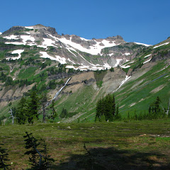
From the four days we spent in Goat Rocks, the second was probably the one with the most variety and beauty. After a hefty breakfast and packing our gear, we hiked back to the junction and headed south traversing the mountains as we gained elevation and got closer to Chimney Rock. Flowers started to appear everywhere but still it was just a teaser of what we would get later. By mid morning we passed Beaver Creek, the second option we had in the possible places to stay the first night. It had a very descent campsite and a good water source but it was occupied. We lucked out. From there we pushed up a bit more to a point where the trail makes a left turn and the whole north view of Goat Rocks opens in front of you. It was one of those wow moments were you have to just stand and take your time taking in the scenery.


Old Snowy from the trail

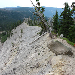
The trail continued skirting the mountain going thru beautiful, wildflower covered meadows and little streams towards Chimney Rock. On one side we had the views of the Upper Lake Creek valley and the other Old Snowy. Finally, after passing Chimney Rock, we got to the ridge and that just opened even more views to the North. From that point, we could see a long portion of the trail as it follows the ridgeline all the way to Old Snowy. We took a short break to grab lunch at that spot and while doing so Brian told us he was having feet trouble. He decided at that point to turn around and hike back to either Beaver Creek or Lost Lake and then make it back to the car to meet with us on Monday. It was a hard call but, as we would learn later, probably a good choice under the conditions we would find later.


View from the Saddle after Chimney Rock

Then the fun started. From that point on, most of the trail just followed the ridgeline which is always fun and offers the best views. Also, you can see pretty much the entire trail which, sometimes can seem a bit daunting. On the way we passed some incredible flower covered meadows with enough lupine to hurt the eyes. The mix of purple, green and blue and the snow on the mountains was just magical.


Val on the trail

As we gained elevation, we left the tall trees and forests behind. The views changed completely to snowy mountains and ridges and plenty of wildflowers but that just lasted until we got to the junction with the PCT. At that point, all the green was left behind. The view ahead of us was both beautiful and daunting as we could see our route as it climbed up, followed the ridge and cross near the top of Old Snowy. By then we were all pretty tired but we still had a while to go. Without taking a break and keeping a steady pace we continued up. As we climbed it was impossible not to stop, look up and also turn around to see what was behind. It’s hard to say which view was better and certainly pictures don’t do it justice here.


Mark and Carole on the trail

At some point we got high enough that it was difficult to understand where we were. It seemed that we were as high as we would get so it was time to start climbing down. But then, we realized it was only perspective. Before the last push up, the trail snakes around the jagged rocks on the ridgeline passing from front to back and to front again. As you do that, you lose sight of Old Snowy and reference of the trail but then, you are greeted with a view of the last portion of the trail up. A winding route that seems almost impossible to walk on.


The last push to Old Snowy

By then I was exhausted and almost out of water which is rare in me. So slowly but surely I continued up trying to save energy and keeping my breath. On the way up we met a solo female hiker doing the entire PCT that told us she was in the forward pack. She looked pretty tired so she continued on without a lot o extra conversation. As if the trail was not hard enough yet, we got then to a point where, instead of dirt and small rocks to walk on, we had big, thin and almost sharp layers of rock. Each step was an exercise in force and balance. Then the summit became visible and a lone PCT hiker taking a break up there. Finally at the highest point of the route we stopped to take a break and enjoy the views and a couple of stories from the PCTer. He was ahead of the pack and wanted to complete the entire thing in record time. He looked like he was going to make it. When his break was done, he grabbed his pack and disappeared, almost running, down the hill. We then continued down on the other side of Old Snowy, finally going down, as the sun was going down as well. Our plan was to continue much further for our second night stay but by then we knew it was unlikely we would be able to make that far with light. So as soon as we found water, we started looking for potential campsites. Surely enough, we found a couple of almost flat spots in a rock field where we pitched our tents. That night we only had time and energy to make dinner and go to bed not without enjoying the fabulous sunset


Sunset from our tent on the second night

Day 3: The real hard day – Campsite near Old Snowy to Heart Lake

On Sunday we woke up to a fantastic sunrise illuminating the hill side and a lone PCT hikers that was probably already very tired from his epic trip. As we started hiking, we commented on our luck finding those flat spots where we stayed and how long it would have taken us to get to where we had planned. Not even five minutes later, we found some pretty spectacular campsites… At least we now know for next time. As we hiked we contemplated following the original idea or taking a shorter way but using trail 96 to connect to Snowgrass Flats and cut a couple of miles from the trip. As we still had a lot of miles to cover we opted for that choice so as soon as we found the junction, we took it and started climbing down. Near Snowgrass Flats we were greeted, one more time, with a spectacular wildflower display. We were clearly in the peak of the flowering season


Flowers on trail 96

Once we joined with the Goat Lake trail we turn north and started skirting the mountain one more time towards the lake. The views along this trail extended from Goat Creek to Goat Ridge and beyond. There was a bit of haze, probably from nearby fires but the views were still beautiful. At around noon, we got to a completely frozen lake were we took a short break and got some glacier water. While eating we saw the inhabitants that give the name to this lake. Across from us, up in the hills, a small herd of goats were grazing and enjoying the sun. Then, we continued up towards the junction with the Jordan Creek trail that we reached after passing countless little streams and fields covered with wildflowers. Right after that fork is the fork with the side trail to Hawkeye Point, the second highest point in the wilderness. Mark, Val and I took our packs off and went for a peek. It was certainly a short hike up and very well worth it. The only problem we found was that it was a small circus. I think all the people we didn’t see during our first couple of days were all up there. After just a few minutes we climbed down, got out packs and continued on to the Lily Basin trail. From where we stood, it looked pretty easy as it circled the valley of the M Fork of Johnson Creek. In fact, although we couldn’t see the lake, we knew where it was. It was just a couple of miles away. Little did we knew that it would prove to be pretty hard to get there


View of the trail towards Lily Basin

So we started on the trail and not even 20 minutes into it, we got to a very steep snowfield. Expecting that, we all had microspikes that we put on before hitting the snow. The going was slow as we need to kick in the snow to make steps. Being mid afternoon, the top layer was pretty soft but the bottom layer was solid ice. As we traversed the ice field our steps got shallower as the hill got steeper. And then I lost my grip. One of my feet just slipped from under me and I fell. AS a slow movie goes, I saw myself tumbling and turning as I was rushing down aiming to a rock field. I tried with both my poles to self arrest but that was useless. As I saw the rocks getting near I braced for impact and tried to stop myself as best I could. I slammed hard on a rock, flew over it, and slid or the rocks for a while until finally all movement stopped. Everything was aching. Slowly I got up and checked and nothing was broken, I only had some pretty big scratches and some broken nails. I had all my gear with the exception of one trekking pole that I had left half way down the hill. Once I recovered, I looked up and saw as Val, Carole and Mark were still trying to cross the snow field. Then the movie replayed. As Mark was trying to get ahead, Val made a half turn and slipped. She felt and started slipping fast towards me and I saw she was going to hit the rocks hard. Out of pure instinct, I dropped my gear and started running up enough to jump up and tackle her so she wouldn’t hit the rocks. Being heavier, I was able to stop her a bit safer than how I stopped. She was ok. And she had managed to grab my pole on the way down! We thought the story would not repeat itself so we started hiking sideways on the rock field only to learn that what looked dry, was actually wet. We saw rivers of mud, dirt and rocks move down trying to carry us down. Mark and Carole continued on the snow. Just as Mark was about to get on solid ground, he also lost his footing and came flying down the snow slope. I don’t know how but I saw him hit a rock and fling himself over it and land on his feet. I was a bit beat up but not as much as Val and I. Then, the snow field was behind and Carole the only one who managed to traverse the whole thing without falling. At that point we knew we were bushwhacking. There was no point in trying to climb up to the trail or even follow it. Besides, from our viewpoint, it looked easier to go lower on the valley and climb on the other side than to follow the trail. We only needed to cross one or two waterfalls


The little valley we need to cross

From that point on, we tried to make our way as best as we could but the going was slow. Every ten of fifteen minutes, we had to stop and reassess our position and decide our route. Several times we had to backtrack a bit as we found ourselves cornered in front of a precipice. As we navigated thru the valley we cursed and complaint but we kept going. Needless to say, the views were amazingly beautiful so it was not all that bad. Late in the afternoon I realized, as I was trying to find a straight way to the lake that there was no way of doing it, but then, looking at the map, I realized we were just a couple hundred feet bellow the trail. So we decided to just shoot straight up until we found it. It was hard push but getting back on trail was a big relief. We still had about a mile to go so we continued as we enjoyed the views of the Heart Lake, our intended destination.


Heart Lake from the trail

From the information I had, I knew there was supposed to be user trail down to the lake and from our standpoint, we could see that people had camped there. We continued hiking but did not find the trail. We thought for a moment what had happened the night before, that just five more minutes would get us there but by then we were tired and wanted to eat and sleep. So we opted for the straight way down the slope. A short bushwhack took us quickly down to the lake were we stayed the night. That night we had a fabulous fire after taking our turn in a nearby creek to wash and bathe ourselves. It felt glorious to eat, rest and go to sleep that night.

Day 4: Spider webs – Heart Lake to Lily Basin trailhead

Monday started a bit later as we didn’t have a lot of distance to cover. By our estimate, we would be out early in the afternoon so there was no rush. The day was incredible with perfect blue skies and warm weather. It looked like it was going to be great day. After breakfast and packing our gear, we tried to find the user trail and as before, we found it. Not only that, once we hiked up and got back on the Lily Basin trail we found that the fork was just a couple hundred yards from where we turned around the previous night. Now we know… that we need to hike five more minutes!. The first part of the hike took us to the junction with the Angry Mountain trail where we turned and continued around Lily Basin. The scenery was a bit different that before with lots of wildflowers and green, lush forest. We were clearly loosing elevation. We found a couple of harder creek crossings but nothing major so the going was easy. That was until we got to the first challenge, a small creek with a snow field covering the trail. If the creek was not near a steep drop off, crossing would have been a piece of cake. So after thinking for a while I grabbed my trowel and started digging footholds. In the end, it took a bit of time but we were all in the other side safely. Then came the real challenge in what I believe was Glacier Creek. Part of the trail had been washed out so there was a small waterfall and a big ice field. No easy crossing. The first part required us to climb down on very loose dirt and rocks to the base of the waterfall. The second required climbing, on the waterfall, back to the trail. It was a pretty good challenge


Mark climbing the waterfall

From there it was finally more or less a walk in the park. The trail snaked in and out of the forest and then opened views of Mount Rainier and then Packwood Lake far below. It was really beautiful, and hot.


Mt Rainier and Packwood Lake

After the views, we finally enter the forest for the last couple of miles of our hike. As we did, weather got really hot to the point that it was really uncomfortable (at least for me). To make it worse, it seemed nobody had hiked that trail in at least over a week as there were spider webs everywhere. It was difficult to hike thru without eating them. But then, just when we were about to walk into the parking lot, we found what probably gave the name TO THIS TRAIL. We passed a small meadow completely covered with Avalanche lilies. It was a beautiful scene watching a green bed spotted all over with little white flowers. Once in the car we drove to the Packwood trailhead were we found Brian waiting for us.

You can check the pictures here


Interactive map

To see the full map, click Menu and select Full Screen. You can also click Terrain to change the map style

Eagle – Benson – Ruckel loop, Jul 28th

This long named hike is actually a combination of several trails to form a long loop and, although it has some good things to look at on the way, it’s more of a training hike than anything else. Just consider that the whole loop is about 15 miles with an elevation gain of over 400 feet. Certainly not for the faint of heart. The hike starts from the same place as the Eagle Creek hike so the first part of it is actually easy, but then you get all the elevation in a rather short distance so it’s good to save some energy for that. My post for this hike described all the details so in the end, it was Val, Jeff and I who took on the challenge. We started early and doing a quick pace on the Eagle Creek trail. As we’ve done this section of the trail many times, we didn’t stop for many pictures or took the normal detours to visits the waterfalls. Instead, we kept a steady pace trying to save time by covering the first 5 or so miles quickly. The idea was to save some time we would use later on the climb to Benson Plateau. Weather was perfect, not too hot or too cold and clear skies. After passing 4½ Mile Bridge, that brought us back to the east side of the creek, we started looking for our detour. About half a mile after Wy'East Camp we found it, a little trail to the left with a worn out sign that is barely visible from the trail. At that point we decided to take a breather, adjust layers and eat something before continuing up. Then came the huffing and puffing. In the next couple of miles we gained most of the elevation of this loop. Half of it was on a good and easy to follow trail, but as we gained elevation the trail got more difficult. Towards the end we found places were the trail was so dense and overgrown that it’s hard to follow. Once we passed the 3600’ mark we finally leveled of a bit and entered the tall trees that signal you are in Benson Plateau. The trail continued up but not as steep as before until we reached a campsite near the junction with the PCT. At that point we decided to stop for lunch and rest as most of the climbing was done. After lunch we followed the PCT to the next junction with the Benson Way trail. From that point on, the trail would be pretty flat all the way to Ruckel Creek. You can take the PCT and go thru the Plateau which eventually will take you to the same place, but we opted for the Benson Way trail as it’s easier to follow and has some openings with views to the west. We meandered thru the forest for a while until we reached Hunters Camp where the Ruckel Creek trail starts. Then we came out of the forest to start our long way down. As expected, our progress going down was as grueling as coming up. The trail is steep in places, slippery in others and rocky in the rest. That combined with the afternoon sun pounding on your head made it a bit hard. We made the necessary stops at the viewpoints to take pictures of Cascade Locks and the Bridge of the Gods but kept our pace going down. We got to a point were the only thing in our minds was getting back to the car which we eventually did, very tired, but with a great sense of accomplishment.


Interactive map

To see the full map, click Menu and select Full Screen. You can also click Terrain to change the map style

Burnt Lake from Enola Hill, Jul 7th

Both Burnt Lake and Cast Lake on the west side of Mount Hood can be accessed via trails that start from Lolo Pass Road. Those trails are really nice although offer some partial views of the mountain right in front of you unless you continue higher up the ridge to get a clear view. An option that is more rewarding, in my opinion, is to go up from Enola Hill. The reason is that the trail takes you over the ZigZag trail which has an incredible view of the mountain. It also gives you a nice chance to explore the south side of ZigZag Mountain where a lot of Devil’s places are. The road to this trail is pretty bad so it takes a bit of time getting there, but once there, it’s likely you’ll have the trail to yourself. The first part of this hike meanders thru the forest as it gains elevation towards the saddle with limited views of meadows. In season the wildflowers are fantastic in the area. Still, for reasons I do not know, a lot of places in the area are named after the devil: Devil’s Lake, Devil’s Meadow, Devil’s Tie, Devil’s Canyon… I guess the devil made a mess here at some point. As you get closer to the saddle, the trail gets steeper forcing you to do several switchbacks, but then, the big surprise comes. First you see the end of the trail, and then you see the trail sign indicating the junction with the ZigZag trail and then, the view. A big drop off in front of you opens the entire west side of Mount Hood right in front of you. It’s simply breathtaking. From up there you can easily spot Burnt Lake down below but that’s not the only place you can get from this point. Following the trail east took us to the junction that then climbs down thru several switchbacks to the Lake. We found a lot of people and even more dogs enjoying the warm weather and jumping in the lake. We took a trail that goes around the lake until we found a nice place for lunch and then continued making a short stop on the south shore to wet our feet in the water. Later we hiked backup to the ridge, but instead of taking the same route down, we continued west on the ZigZag trail to the East ZigZag lookout for even better views. There are still numerous options to continue from here but to return to our cars, we took the trail that heads down to Cast Lake and then the Devil’s Tie that connects with the ZigZag trail farther down. From there we retraced our steps down to the car to finish the nice, close to town hike


Interactive map

To see the full map, click Menu and select Full Screen. You can also click Terrain to change the map style

Mt Saint Helens, Jul 4th

If you hike or backpack or do outdoor activities in the Pacific Northwest, climbing Mt Saint Helens is something that should be on the to do list. Usually this is one of the first peaks I hear people climb as the only thing you need is permits. I think I kept from doing this as getting the permits is one of those things that you have to plan way ahead. Problem with that is if weather is bad then bad luck! This year Val started talking about it so we decided to check permit availability and found that most days were already taken except the 4th of July (a Wednesday). Since we didn’t have a lot of interest in doing the BBQ and fireworks thing, we got permits for that day. Mark and Carole were lucky as well to get permits for the same day so we formed our little group to climb Helens that day. I was very excited as I hadn’t done it yet and Val was excited as she was going to learn to glissade. That day we woke up to an almost perfect clear sky and drove early to Climbers Bivouac where we met with Mark and Carole that spent the night there. After getting our gear ready, we started our journey and not even 10 minutes into the hike, we found snow. That was both good and bad. On one side, it can make the hike go a bit slower as you are sliding around in the wet sludge but on the other, it makes coming done so much faster and way more fun. The first part of the hike was thru the woods without a lot of views so we did some “catching up” with Mark and Carole. Then we came out of the trees to a cloudless blue sky. Behind us we had Mt Hood and a very faint Mt Jefferson and to the East, Mt Adams. As time passed and we continued our climb, we left the green forest behind and got to the snow and rocks that would dominate the scenery. While climbing scenery doesn’t change much. You cross from snow field to snow field, pass thru rocky sections see the different paths people have taken coming down. You also get a good sense of perspective as you see the line of people ahead and behind you. Then finally the view changes a bit as you see a definitive line and nothing but blue beyond that. A little bit of a push and you get to the “summit” or better yet, the end of the trail. Yes, it is a bit anticlimactic but let me explain. In winter the rim gets a lot of snow and the wind extends the cornice far from the actual edge. In the past, people have pushed beyond and have fallen to the crater. So now, when you get there, you see markers that diminish the perspective of the crater (you pretty much can’t see it from that point). Now don’t get me wrong, the views around are incredible. You see part of Spirit Lake down bellow, Mt Rainier, Goat Rocks, Mt Adams… all of it. Now the good part comes if you walk a bit to the west to a small saddle. From that vantage point, the whole crater opens up in front of you and that’s where the icing on the cake is. Looking at the crater from that angle is just unreal. You can see the dome inside the crater and how several places are constantly smoking. We took a short brake near the cornice where could be out of the wind and then started our descend. With all the snow, we pretty much glissaded the entire mountain down going from slope to slope. It was a very fun way to end the day and yes, Val ended mastering self arrest.


You can check the pictures here

Interactive map

To see the full map, click Menu and select Full Screen. You can also click Terrain to change the map style

Devil’s Peak, Jul 1st

Another Oregon Devil… this hike climbs up like there’s no other mountain anywhere. In fact, a lot of climbers use this route for training as they carry water up to the top. But, as with most hikes that are difficult, the rewards are well worth it… as long as weather cooperates that is. As you climb up, there are several view points were Mt Hood is right there in your face. At the top, there’s an old fire lookout tower that is open to the public. The tower is user stocked with food, water and fire wood so there’s the possibility, if the cabin is empty, to stay the night up there. On clear days, the views of Hood are just incredible. Not our luck this time, but we did get a pretty decent workout.


Interactive map

To see the full map, click Menu and select Full Screen. You can also click Terrain to change the map style