Owl Point and Perry Lake, Oct 17th

Having done a lot of the hikes in the books, I’ve started to research some not so common places by looking at maps and other sources. This hike is one of those forgotten trails which are only maintained by the few hikers that usually go there. I wanted to head there for two reasons, to check out the unusually view of Mt Hood from the north side and see one of the smallest named lakes in Oregon. Also, this hike offered a chance to do some route finding and bushwhacking. So we started from the Vista Ridge Trail Head and just before we got to the trail sign, I found the very faint route to Owl Point. The first part of the hike just meanders thru the forest without a lot of views but you know they are right there as light filters thru the trees. At about a mile from the trailhead, we found our first view point which gave us a view of the rocky edge at Katsup Point. My original plan was to explore that and also the Red Hill or our way to Owl Point so we took off the trail for a while following what looked like a foot path which didn’t go where we needed it to. So after circling around for a while, we got back to the main trail and shortly after found a trail sign for Owl Point. Not only the sign was unexpected but also that it was put here recently. We followed that path to a meadow with open views of the north side of Mt Hood, the Hood River Valley and Laurence Lake in the distance. We stopped there for a while to have lunch and enjoy the views before continuing on our way to Perry Lake. After getting back to the main trail, about half a mile further, we found Alki Point, another opening but this one looking north. From here, the views extend all the way to Mt Adams, Mt Rainier and St Helens. From that point on, there aren’t many views although the trail goes by the remnants of some old fire lookout stations. To get to Perry Lake from there, we followed an old 4WD road down until we spotted water to the side. As you’ll see in the pictures, Perry Lake looks more like a pond than a lake. I guess it has a name because it doesn’t dry up in the summer. On the way back I asked the group if they wanted to try to find Katsup Point but once we got there and started bushwhacking they changed their minds so we headed back to the cars. In the end, I left a couple of things unexplored so I guess I will have to do it again


You can check the pictures here

Thomas Lake to Blue Lake, Oct 16th

This is probably the best known route in the Indian Heaven Wilderness and a route I’ve done many times, not only as a day hike but also while backpacking in the area. Still, it had been a while since I’ve done it so I took the chance of co-leading the hike with Duane who’s training to be an assistant organizer in my group. The hike was as beautiful as I remembered it although it felt shorter. As we started from the trailhead, we quickly got to Thomas Lake and then passed thru several other lakes with beautiful scenery. We took the hike slow and easy with plenty of rest stops to enjoy the fall colors and the weather. Once we got to Blue Lake, half of the group wanted to do a little bit more while the rest stayed back. So I took them on a bushwhack climb following the ridge behind the lake. As we were gaining elevation, the view of the lake became better. We also got some nice views of other lakes in the area and Mt Adams peaking over the ridge. We did climb as far as we could but at some point, getting closer to the top, the ridge got pretty steep so we had to turn around.

Mt Margaret, Sep 25th

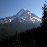
Mt Margaret has been in my radar for some time but I never thought about going there on a day hike. On one side, this area has a lot to explore making it better for a backpacking trip. The problem is usually getting permits as this fragile area is highly restricted. The other thing is that it could be a long day for just a hike. Mt Margaret is located on the north eastern side of Mt St Helens which is basically the blast zone of the volcano. The scenery is a bit eerie as all this area has been slowly recovering from the 1980 devastating eruption. You certainly find some vegetation and beautiful colors that are all contrasted by the thousands of downed trees. As you’ll see in the pictures, it almost seems that a gigantic comb passed thru the area leveling everything. So with nothing else to do on sunny day in September, I decided last minute to get my gear and head out there to check at least a section of Mt Margaret. I started hiking from the Norway Pass Trailhead, a pretty isolated area that gives you a quick hint at the scenery you’ll see the rest of the day. The first portion climbs on the boundary trail towards Independence Pass where several trails meet and you get the best view of the volcano. As you get there, the views open up in front of you with Spirit Lake at the foothills of Mt St Helens. I can safely say that this view is reason enough to hike this trail. You get views of new growth on the hills, the lake with its shore completely covered with dead trees from the blast and the immensity of the crater above.

View from Independence Pass


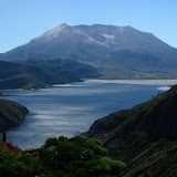
From the pass, the trail continues gaining elevation as it circles around the eastern side of the lake. As you do that, the other volcanic peaks start to show up behind the ridges. On the other side of the ridge, what is known as Mt Margaret Backcountry also starts to appear. This is a deep basin with several lakes and incredible scenery. From different points along the ridge, you can get some views of Shovel Lake down below and the rocky ridges that circle the area. The only common scenery is the pattern that all the downed trees create. It was incredible to see areas that were devastated and how they have recovered to beautiful postcard scenery. Along the ridge, I got a nice view of a small valley along a creek that flows to Spirit Lake that’s a perfect example of this

Postcard scenery


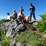
Shortly after that view, I got to the fork with the Whittier Ridge Trail. From pictures and reports I’ve seen, this is the hardest part of the Mt Margaret Backcountry loop. The trail follows the rocky ridge which has been blown or eroded. I decided to take a quick jaunt to check it out. I guess I didn’t do the whole thing or didn’t reach the hard section although I can say that the trail is not for the faint of heart. It does follow a very narrow line on the side of the ridge with a very steep drop off to one side. After a while and seeing that time was running by, I turned around and got back to the Boundary Trail. From there I continued for a while until I found the side trail to the top of Mt Margaret. I got there just at the time I had set up to start hiking back but with that scenery, I had to sit and enjoy it for a while. The views from up there included Spirit Lake, a clear view of the Crater, St Helens Lake and the volcanic peaks. Then it was the hike back. Being a bit late, I had to hike a bit faster to get back to the car before dark. Oh what a day!

West – East Zigzag Lookouts, Sep 11th

Besides getting the views of Mount Hood right from its base, there are numerous ridges and smaller peaks around that offer first row views of our magnificent mountain. One of those is Zigzag Mountain. Located in Zigzag (I don’t know if the town named the ridge or the ridge named the town), this ridge offers some of the best views of the South West side of the mountain. There are several trails that can go to either of these lookouts and one that connects them together giving the possibility of doing a loop hike. We started from one of the access points to Burnt Lake which is a steady uphill hike thru a dense forest without any views until you get to the ridgeline. Once there, the scenery just becomes fantastic as you get an incredible view of Mt hood. Down bellow, between the tress you can easily make Burnt Lake which is also a nice hike and even better spot to camp. From the junction we continued south until we got to our first stop, the East Zigzag lookout. It’s a rocky top with open views of the valley that extends to Mt Adams, Mt Rainier and St Helens. On the other side of the lookout, we started descending a bit and took a detour to Cast Lake. This lake is relatively close to Burnt Lake but not as visited. It does have some nice camping spots but people usually prefer Burnt as it offers a clear view of Mt Hood. Cast on the hand, is very secluded so you only see the trees around you. After a nice lunch, we headed back to the Zigzag Mountain trail on our way to the West lookout. After a bit of ups and downs and some meadows, we finally got to it. Although this lookout doesn’t have a clear view of Mt Hood, it does offer a good view of the towns of Zigzag, Rhododendron, Boring and the Hwy26 corridor. We also found the remnants of the old fire lookout that once stood here. Exploring around, we circled the ridge and found another good spot where we took our last pictures of Mt Hood before heading back down to the car.