Ghost Ridge out and back, Dec 18th

After two very low snow years we finally got a break. Early in December we were hit by several winter storms that dumped a lot of snow up in the mountain. Before the holidays the snow pack was already at 140% of normal. The bad side of this is we had a couple of weeks were we had to stay home as you couldn’t go anywhere. Well, that’s not entirely true. We could snowshoe around the house. Finally, we saw a window in the weather so Val and I, instead of doing our classic White River outing for our first snowshoe of the year, we opted for Ghost Ridge. On one side, we didn’t want to deal with lots of people and on the other, we wanted some fresh powder so we picked one of my favorite routes. Getting there wasn’t as bad as we thought it would be. WE were pleasantly surprised to find the parking area almost empty. The mountain to ourselves. After gearing up and bundling up (it was crisp and very cold) we started our march on the PCT. It was like a dream. Fresh, deep snow everywhere. Even the tracks were soft. We noticed tracks once we veered of trail towards the ridge and decided to follow those. Once we got to the opening the views expanded to Mt Hood on the back and all the way down the valley to he west. It was hard to say how far we could see. As we continued up the ridge, we saw a couple with a dog sitting and enjoying he views. Right after that, we took a detour following other tracks to a view point where we found a backpack that was recently left there but nobody with it. Kind of strange but didn’t make much of it. Once we got back to the viewpoint were the couple was sitting, we noticed there were no tracks going forward. It was time for us to break new trail. The going got a bit slower but the mountain was ours. Each step made the views even better until we got to the top. WE continued for a bit on the ridge to an opening that hadn’t been stepped on and stopped to enjoy some soup, the silence and the views. We did consider continuing back down for the longer lop but knew that, with this much snow, we could that at some other time so we opted for returning the way we came. If this stays like it is, is going to be a great snowshoeing year!

You can see the rest of the pictures here

Interactive map

To see the full map, click here

Hardy Ridge and Phlox Point, Nov 26

Tired of the bad weather and non-stop rain, Val and I took a chance and went out to the Washington side of the Gorge to re-do a hike that was barely in our minds even though it’s one where we both worked on building part of the trail some years ago while volunteering with WTA. As soon as we got to the parking lot, the memories started to flow back in... “my tent was there” and “so and so were sleeping over there”. This day, with a heavy grey cloud cover, we found the parking lot complete clear with the exception of a single car. It looked like it was going to let loose at any time so we grabbed our gear and started our hike on the equestrian trail going towards the East ridge trail. From there, we started climbing steadily thru the dense forest with no views and the menacing skies above us. That changed a bit when we got to the junction with the Phlox Point trail. At that point, we had a complete view of the Gorge, the heavy cover above us and some lingering clouds in the valleys. It didn’t look like it was raining anywhere so we continued up towards the view point at the end of the ridge. In the distance we could see Mt Hood under the clouds and the sun trying to make its way thru. WE stopped for lunch at a spot just below the end of the ridge where we got a bit of better coverage from the wind. After that we started our hike back to close the loop on the Hardy Ridge trail but before that, we noticed the small clouds on the valley starting to climb up the side of the mountain. As they did, they grew bigger but for some reason, the never passed the ridge. WE were, for a short period of time walking right next to the clouds as if it were an ocean beach with the waves breaking on our side. It was quite the spectacle. As the trail made a turn to start descending we saw that the valley was not complete under the cover of a low hanging cloud. Each step we took, brought as closer in to the cloud until we were inside it so the rest of the hike was pretty much thru a foggy forest. IN the end it never rained on us and we got a good hike in, nothing to complain about.

You can see the rest of the pictures here

Interactive map

To see the full map, click here

Tom, Dick and Harry, Oct 22nd

Finally, we got to plan a hike with some of the guys I work with. In the past, whenever the remote guys are I town, I’ve tried to organize and outing. On every occasion we had to cancel either due to weather or because there was something else going on. This time we finally were able to do it and even despite the bad weather we had the entire week, we were lucky to have a small window of blue skies, crisp fall air and amazing views. In contrast with leading hikes with the group, I meet everyone at the hotel and we split into a couple of cars to head up to the mountain. After getting passes, parking and passing around some extra gear so nobody would freeze we started of the well covered trail towards Mirror Lake. It was wet and humid making it feel a bit cooler than usual, but we kept our pace and pretty quick got to the junction with the lake. On the way up, I decided to go around the lake so we crossed the bridge and took the west side trail where we got out first views of the lake and our destination. On the other side, we got the classic reflection that is always good for numerous pictures. After that short break, we took the trail to the top of the mountain which went pretty well making only a short stop in the opening that faces Hwy26 and gives you a limited view of Hood. From there we marched our way to the top which, for first timers is always a treat as you don’t see anything until the very last step when the view opens up with Mt Hood right in your face. We stopped there for the pictures and grab something to eat while being almost blown away. Just when our toes and fingers were starting to feel the effects of the wind, we started our hike back retracing our steps but without going around the lake. It was a great hike that ended with some beers at our usual stop at Sky Way.

You can see the rest of the pictures here

Interactive map

To see the full map, click here

Elk Cove to Dollar Lake, Oct 8th

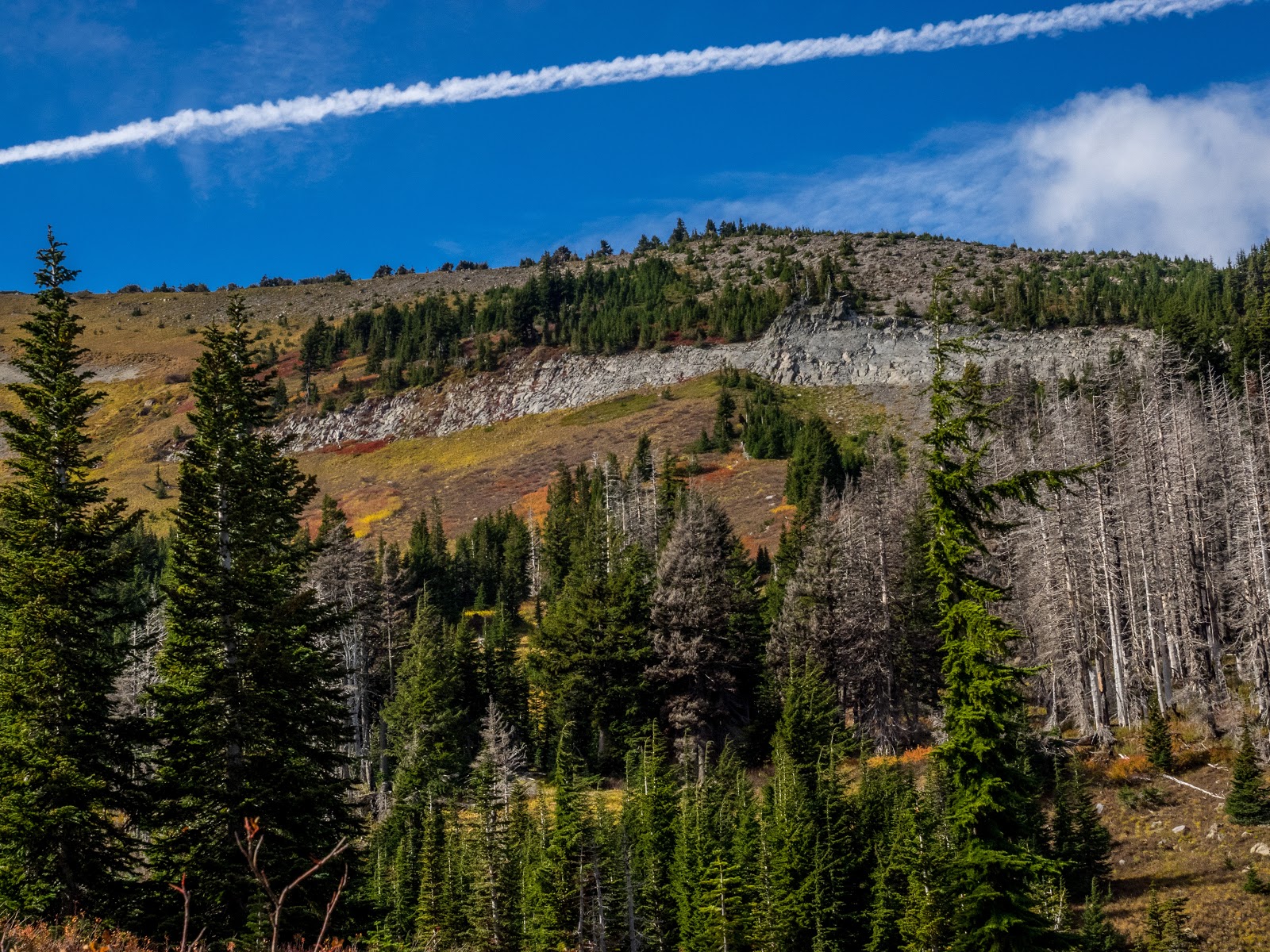
I was looking at a map with the different trails I’ve done and noticed that I’d gone a couple of times to Dollar lake but always from the east side, either from Vista Ridge or Pinnacle Ridge but never from the Elk Cove trail. That seemed reason enough to post it and go check it out. The trail originally started from road 650, but since the bridge is impassable, you have to park along road 2840 and hike a short portion of the 650 road to the original trailhead. Even though you start with that, the views are not disappointing as you get some views of the Pinnacle Creek drainage to the north. Then, when you find a cairn and make a turn, you get into the forest and start gaining elevation. By then you are already on the ridge with some pretty impressive views. Part of it is because most of this area was burned several years ago. Pretty soon you get your Mt Hood fix right in front of you. The trail just follows the ridge so the views are non-stopping. There’s a section of the trail where there’s a small rocky butte you come to where the trail makes a slight right turn. You know when you’re there because the rocks call you to get on top and enjoy the view. If you don’t go farther than here, you have gotten the eye candy for the day.


After that point, the trail descends a bit and continues on the ridge towards the Timberline trail. In this section you get more in the forest and some of the views disappear for a bit as you enter Elk Cove. Once you reach the unction with the Timberline trail, the views become completely different to the point that it seems you are in a different hike altogether. For starters, Mt Hood is not there and you are surrounded by a small valley with some interesting rock walls and ridges. You can almost see why this place is called Elk Cove, if you were an Elk, that’s where you’d be… As you travel south (counterclockwise) on the Timberline trail you meander a bit thru this valley before a shallow climb to a saddle where, if you look back, you get your Mt Hood view again. After the saddle the views again change as you are looking at the Pinnacle drainage. From that point on, you have to pay attention to the trail and look for the small cairns on both sides that indicate where the trail to Dollar Lake is. Yes, it looks like a user trail but that’s the way up to the lake. As with most things this year, we fund the lake pretty low but very round as always. We stopped there for lunch and while enjoying a bit of refreshing time, I walked around the lake to a small ridge on the east side where I found a couple of campsites and what looked like a rock oven. I guess is there because the views of the mountain are again pretty outstanding. Then, after our lunch break, we retraced our steps back to the cars.
You can see the rest of the pictures here

Interactive map

To see the full map, click here