Mt Hebo, Feb 28th

The guide for this hike doesn’t even get close to what you actually get. Mt Hebo is usually recommended as nice hike with amazing views from the top that can extend to the Cascades on the East and the Pacific Ocean to the West. It does warn you that these views are a bit elusive as it’s difficult to get a clear enough day to enjoy them. The other highlight of this place is that there used to be a naval Radar Station during WWII. All that sounded interesting enough to try it out so I organized a group of people and headed that way. Finding the trail was not difficult at all as it starts from a small but beautiful lake in a campground. I guess in the summer this place is full f people but considering is very early in the season, we only saw one group of people on our way out. What the guide doesn’t tell you is that you have to hike thru one of the most beautiful coastal forests I’ve seen. It might have been the perfect weather, but the ferns and moss covered trees were just incredible. It got to a point that the green color was almost hurting your eyes. Shortly after, as we were gaining elevation, the forest changed completely to a more uniform, tall, second growth forest with a thick fern covered floor. Although there were may trees and lots of ferns and vegetation, you could still see far ahead. The other interesting finding in this forest was the silence, no road noises or anything like that. Roughly half way up, we got to the road (which is intended) but on the other side we missed the trail as it was a bit obscured by some shrub. Instead, we continued on the old access road to the antenna site. This road goes around the west side of the mountain and eventually gets to the top. From there we just crossed the grass field to the north side where the real summit is and were welcomed by some nice expansive views to the coast. After taking a bit of time to have lunch and enjoy the views, we went to South Point to explore and then back to start our descent back to the cars. Trying to find the trail, we followed what looked like an animal path but ended up loosing it, so we had our fair share of bushwhacking to get to the trail again (and that’s how we noticed the trail we missed on the way up). Once back down, we circled the lake to take some pictures before getting back to our cars. As it’s customary, some of us went out for dinner on the way back so we opted for the Pacific Ocean loop that takes you around the coast. There, we stopped at a restaurant sitting right on the beach in front of the Haystack. As you’ll see in the pictures, we ended our hike with a beautiful sunset on the coast.

Hole in the Wall, Feb 27th

Hole in the Wall is one of those hidden treasures right here in Forest Park in the middle of the city. Incredibly enough, this hike offers excellent forest views, some secluded trails and the feeling that you are miles from the city when you are not more that 25 minutes from home. I normally don’t do a lot in Forest Park hikes as I like to explore farther regions, but considering I had only the afternoon and wanted to take Shia out for a walk, I though this would do it. I arranged with Laurie for her to pick me up on the way and head of to the trail. Weather was fantastic and the trails were as they normally are, full of mud. What was interesting was to see flowers’ starting to bloom considering it’s the end of February and we are still in the middle of winter! Shia had a great time and got in every mud hole she could find. I guess the only bad thing is that I think this is her last hike. Although we did only about 4 miles in relatively flat terrain, she got very stiff and needed two days to fully recover. It always amazes me that she’s always in the mood to run and play and fetch although her body can’t keep up. I wonder how does that work in her mind (if it does at all). I guess she will always think she’s still a puppy and behave like one. I hope my mind ends up working the same way and I can keep hiking way past 80!

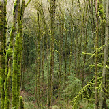
Crater Rock and the Hogsback, Feb 19th

Usually when I write these stories, I kind of re-do the whole trip by watching the pictures and follow the different turns and views I get on the way. This trip is a bit different. Rarely do you do a hike that is both long and hard but where you can see your entire route from start to finish. Not only that, being a somewhat straight line out in the open, there are only two views, forward and backwards. All this might seem boring, but that depends on the scenery. If you put our beautiful Mt Hood in the same context, everything changes. When looking up towards the summit of Mt Hood from Timberline Lodge, there are three prominent points. On the left (west) is Illumination Saddle, in the middle you see Crater Rock, a huge pointy rock, and to the East, the summit. Just between Crater Rock and the Summit, there’s a saddle with a clearly visible line. That’s the Hogsback, the highest point you can get to without having to use specialized climbing gear. From this point forward, reaching the summit of Mt Hood, although is not a long trip, it’s a technical one. The beauty of all this, and maybe the reason to do it, is that you get the best close and personal view of the top of this magnificent place. On this first try, we started before sunrise, not only to allow us plenty of time but also to get the best solid snow. As you’ll see in the pictures we just walked up until we turned around and headed back down. There’s not much to tell from the hike itself. What I do need to report though is that I re-learned what I already know. The weather up there can change without notice. When we started it was a very cold morning with temperatures below freezing that never went up during the whole day. A light breeze accompanied us all the way up which ended up being the reason for turning back as my hands and one foot where getting cold to the point of pain despite the fact of three layers of socks and two layers of gloves. I was still able to get above Palmer lift, somewhere around 8700’ before turning back and was able to enjoy that wonderful view. Certainly the mountain got its respect, but I will definitely be doing this again… many times.

Silcox Warming Hut, Feb 13th

With weather still kind of bad and without a lot of new snow on the ground, it occurred to me that snowshoeing at higher elevations might be a bit better. With that in mind and thinking about combining or adding some fun to the hike, I thought about climbing all the way to the Silcox Warming Hut in Mt Hood and the glissade most of the way down. Silcox Hut is a rustic mountain lodge located at 6950’ roughly 1000’ above Timberline Lodge. This hut was built back in 1939 and thru history; it has passed from hand to hand. Back in 1985 it was added to the national registry of historic places and today it’s managed by the same group that managed Timberline. Presently, the hut can accommodate 24 people on special events. Weather for that day was looking grim with very little chance of any sun. As you’ll see in the pictures, we got even less than that, but it was a very interesting trip. Rarely do you get a chance to be in the mountain in full white-out conditions!
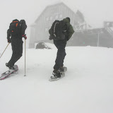
To start this Snowshoe, we drove a bit past Government camp and took the trail towards Tyee Lodge. We made a quick stop to pick up Jeff who was going to accompany us at least for part of the way. From there, we started our walk up on the West Leg Trail until it met with the Alpine Ski Trail, a trail that connects Timberline with Government Camp. That section was probably the steepest one and, as we were going up, we were getting closer and closer to the clouds. As soon as we got the base of one of Timberline’s ski lifts, we were completely in the clouds with very little visibility. On any other normal hike, this would have been enough to turn around and head back, but since we were following one lift lines, there weren’t many chances of getting lost. So we continued on with views of pretty much nothing. Now don’t get me wrong, not seeing anything is very impressive as well. After a while in these conditions, we got to the top of the lift and found ourselves right in front of the lift building but no Silcox Hut. We could actually hear the Sno-Cat close by but with no visibility and not knowing how close or far the hut was we decided to stay where we were. We got in the buildings basement to get out of the elements and grab a quick lunch before heading back down. Our original idea, as I mentioned, was to glissade down from there but with no visibility it would have been a bit dangerous. We ended up snowshoeing our way down until we got back to the Alpine trail at which point we took our snowshoes off and exchanged them for our sliding contraptions. I don’t think I need to go on the details of how much fun was to slide down the rest of the trail back to the lodge and to the cars. Watch the pictures and you’ll get an idea.

Clear Lake Butte, Feb 6th

So this was an experimental snowshoe in an area I have never been to before. Weather was supposed to be nice but we only got a very dense cloud cover and pretty much no visibility. With all that, well, it didn’t go exactly as planned. The Clear Lake Butte area is a sno-park located a couple of miles south of Government Camp. The cool thing about this area is that you have a butte with a fire lookout tower that can be rented during the winter. The views from the tower are supposed to be just stunning as you have Mt Hood right in front of you but you can also see the White River Basin and several lakes around the area. In the park there’s also a small lake, Little Crater Lake that is not too big but apparently very deep. I’ve been told that it never freezes but I have to see that for myself. Unfortunately, the loop trail that goes around the Butte doesn’t allow you to do both things in one day so I came up with a plan to traverse straight to the Butte and then continue on the other side straight to Little Crater Lake. As luck would have it, we didn’t find the trail markers we needed to head out so we ended up hiking in the wrong direction. Once we found out about that, we corrected course and started navigating off trail in the direction of the Butte. By that time we had already spent about an hour so the chances of doing the whole loop where looking really slim. As we where navigating, it seemed that our path was not as steep as it needed to be. Without any views to get a reference, we got to the conclusion that we were following the right direction but parallel from where we needed to be. Since the Butte is the highest point in the area, we decided just veer off and just go up. That actually worked as at some point we got to the lookout tower. As you’ll see in the pictures, there was no view at all so instead of continuing to the lake, we made a straight line back thru the forest which ended up being a lot of fun as the sow was perfect. Despite the fact that we didn’t finish our intended loop and didn’t get to the lake, it was a great discovery day. Certainly a place I will revisit with better weather.