Wild Photo Frenzy at Columbia Hills, April 26th

Another hike on the eastern side of the Washington state. Michael, an avid hiker and photographer organized this hike that originally was planned for the Tom McCall preserve in the Oregon side. Since spring has been delayed quite a bit due to weather, we found there weren’t that many flowers at McCall. Luckily Michael had a plan “B”. We drove for about half an hour to the Washington side to a trail called Columbia Hills. This trail is a service road that climbs to a ridge were a lot of FAA navigation antennae and beacons for air traffic control are located. Being farther East than even the Klickitat trail which I did last week, the scenery was completely different to what we’re used to. This time we found ourselves doing a soft climb with incredible views of the valley of the Columbia and also to the north towards Mt Adams. As the name of the hike states, this one was not for the views (which were pretty amazing anyway). It was all about the wild flowers. As you’ll see in some of the pictures it almost seems there were none. That wasn’t the case. All the flowers in this album, with just a few exceptions, where very small. Taking the pictures required getting down to your stomach or knees and very close. On the way back, instead of walking back down the road, we decided to cut thru the open field. That’s where we took the majority of the pictures. We also found some rolls of barb wire that made an excellent opportunity for some experimentation. At the end, we all ended up with some bruises on our knees and legs, dirty clothes, maybe a couple of ticks here and there and more than a handful of real good flower shots.

Hike the Klickatat trail, April 19th

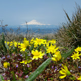
This was one of those hikes that you either love or hate. Hate because is about 12 miles so you can’t stop frequently to take pictures but love because the scenery is beautiful. Hate because the trail is nothing more than an old rail track so it’s covered with small rocks large enough to slip but love that it goes down next to a creek. This trail is located in the Washington side all the way up in the high desert. As you will see in the pictures, the scenery is completely different to all the other hikes I have done in the past. It’s dryer and certainly there aren’t that many mountains. Vegetation is also very different. The whole trail is about 31 miles and is the old rail tracks that connected the cities of Lyle and Goldendale. The train tracks are no longer there, only the bridges and iron pieces from the tracks. We started by driving to the end of the trail near Klickitat where we left half of the cars. From there, we shuttled in two cars to the point where we started the hike. Although it was a bit cold and windy, it was a fabulous bright sunny day. This was very lucky for us since there was a snow advisory for the Columbia River Gorge and the Portland area. According to the forecast, it was supposed to snow and rain all day long. Not for us, we only got a bit of hail with full sun. We started the trail at an open field walking next to the river that soon took us to the canyon. Along the way we found many interesting things. Although hunting is not allowed in the area, we did find a couple of carcasses, probably from small animals. Further down, vegetation changed a bit and we did enjoy the flowers and the new green fields. For a long while, everything was pretty much the same. Great scenery mixed with new flowers and bright colors. The trail got a bit weird after a turn where we found a wood burning stove in the middle of the trail next to a sofa. There was some other stuff near by. As we continued walking, we found a couple of RVs and old construction debris. It seemed to us that someone lives there although we did not see anybody. Further down, we found another set of RV’s and signs of people living there. On this second place, it was a bit stranger. On one side, there was a boat converted into a house. On the other side of the trail, there was a bus converted into a house. Weird. Our final reward for the day came when we drove back to get the cars at the trail head. The looks of the valley and the weather systems moving in were just incredible. It was a very interesting hike which will probably never be repeated.

Hike to Tamanawa Falls, April 13th

This was a short hike that ended up being a bit more challenging than expected. It was about 5 mile round trip with an elevation change of no more than 600’ which on its own sounds pretty decent but adding the fact that it starts at 3000’ makes a big difference. With all the snow we’ve had this past winter up in the mountain, snow at this altitude is still pretty thick so the whole trail was covered. It wasn’t bad but enough to make it slippery. This trail is located on the eastern side of Mount Hood and follows the cold Spring Creek up the mountain. The trail started right after crossing a wood bridge over the creek. From that point on we walked all the way with the creek and some beautiful little falls on our side. Clearly spring is pushing in but it hasn’t got here yet. Views were very nice all the way up to a point were it seemed we couldn’t continue further and reach the falls. At that point everybody turned back except for Paddy that was already far ahead. Chris and I went looking for him and at the turn of a ridge we met up and he mentioned that we were very close to the falls. We decided at that point to head on (just the three of us) and get to the falls. That ended up being a great decision. This waterfall is probably one of the prettiest I’ve seen so far here in Oregon. Or our way back, we stopped at Full Sail in Hood River for some food and drinks.

View pictures of the hike

Walk with Dogs at Dog Heaven, April 12th

This was a walk that Shia planned and asked me to lead. We went to dog heaven, a big extension of land where dogs can run free, play and get dirty. You might recall this place since I wrote about it some time ago. This time, with much better weather, turned out to be a fantastic day. We took a different route than last time that took us directly to the Sandy River. On the way there, Shia found a mud puddle that was too good to miss. You’ll see in the pictures what I mean by that. She was a very happy dog. From there we continued to the Sandy river where we stopped for a little while to enjoy the views and take some more pictures while Shia went for a swim and cleaned herself up a bit. We then crossed the fields towards the Columbia where we found a shady spot to have lunch and enjoy ourselves. On our way back, we circled around were the Sandy river meets the Columbia and went all the way back. It ended up being a great day for the dogs and ourselves.

View pictures of the walk

Dress to Kill hike, April 1st

This was the first theme hike the group has ever done. To celebrate April fools day, Jeff decided to organize this short hike which he called the Dress to Kill Hike. The rule was very simple; wear anything that you would never wear on a hike. On that thought, the first thing that came to mind was cotton. But after thinking about it for a while, if we were already dressing for it, we could do much better than just wear jeans. Most people that showed up had similar ideas so everybody was dressed “appropriately” for the hike. About 45 people showed up for the hike that took us from the Zoo to Pittock Mansion in Forest Park. Besides all the costumes and funny dresses, we had lost hikers, beverages and cake served at the mansion and numerous photo shoots. It was a great event and most probable the first of many to come. We’re already thinking Hallowing!

View pictures of the hike