Barlow Ridge, Jan 31st

This is the second or third time I do this route and every time I like it even more. The weather forecast for the day was kind of a mix, cloudy with chances of precipitation but also some sun so we didn’t know what to expect. After meeting in the usual place and heading up there, it seemed the day was going to be overcast and not very good. In the pictures you’ll see that for most of the hike up, following the old Barlow Ridge road, we had a very gray day. At some point though, a gust of wind cleared the sky and we had our first glimpse at a full blue sky in front of us. That did not last long but it didn’t stop us either. We continued up enjoying the views of the White River Basin as the road turned south to a shadowed area. As I had planned it, after a couple of hours we finally got to the point where we found no tracks to follow, just brand new snow (and probably the best snow of the season). From that point on, the idea was to turn around and go backcountry to the top of Barlow Butte and then head back down to the trail to return to the cars. This portion of the hike was just fantastic with deep snow and quickly changing weather patterns. When we finally made it to Barlow Butte, we were welcomed with a vey hazy day and very nice light for a couple of shots. We stayed there a couple of minutes just imagining the views as we couldn’t see anything. As luck would have it, as soon as we turned around and started heading down, the sky cleared out completely so we made a run back up to enjoy the real views, not the imagined ones. After taking all that in we started our descent which ended being a lot of fun. Hiking thru the trees on a steep down hill with lots of snow allowed us to slide, run, jump and pretty much tumble our way down back to the trail. Once there, we headed, under the sun, all the way back to the parking lot where we were received by some pretty amazing rays filtering thru the trees. How could someone not love this hike.

Trillium Lake, Jan 30th

This is a loop I’ve done many times and is great when you have a group of people trying snowshoes for the first time. Although weather didn’t cooperate much, it was a great day to hike around the lake in the company of friends and some crazy dogs.

Elk – Kings traverse, Jan 23rd

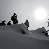
While we still wait for some good or at least decent snow up in the mountains (which seems like will not happen this year), I decided to do a more spring-summer hike. Looking at my many sources and wanting to do a long hike, I opted for the coastal range knowing that it would be clear of snow. About a year or so ago, I recalled doing Elk Mountain. On that particular trip, I took Shia with me and we both ended up pretty beat up after that grueling hike. This time, with a small group of avid hikers, we went with the plan of completing the full traverse that includes the Elks and Kings summit. To give you an idea on how grueling this hike is, just consider that you climb about 2000’ in about 1.5 miles to the top of Elk. From there, the trail has numerous ups and downs, many of which require the use of knees and/or grabbing to branches or roots to climb up or down. In about 2 miles, you get to the junction point about 200’ above Elk only to continue on an equally hard terrain to the top of Kings. This section is about 1.3 miles climbing 300’. After all that, comes the downhill section which is no easy task either as you descent 2500’ in about 2 miles. To complete the loop and get back to the cars, the last portion requires an easy 3.5 mile stroll with some ups and downs. The rewards for all that work, besides the sense of accomplishment, is the magnificent views of the Tillamook Forest. As you’ll see in the pictures bellow, the climb is so quick that you find yourself above the cloud level soon after you start. From there, the views are just magnificent as you see the Wilson River Basin to one side, the coastal range to the west and the forest to the North. All that, accompanied by a nice wet day with some sunshine in the afternoon made it for a perfect winter day?

Cape Horn, Jan 17th

Cape Horn is one of those hikes we hear about but we are not sure where it is or what does it offer. Luckily we had Ryan, a member of the group that wants to become an assistant organizer lead this hike. He works for the Washington Trails Association so not only he knows this trail very well but he also knows the history and all the debates going behind the scenes as they get ready to close a portion of it for work. The trail is located on the Washington side and offers great vistas of the Columbia Gorge. After a short drive to the trailhead, we started our hike on a very foggy day. The first portion doesn’t offer much as it climbs rather quickly passing thru some dense forests and bordering some private land. Soon after that, we got the ridge and veered back on a section that is privately held. At the moment there’s no trail, so doing the loop requires walking on a paved road for a while until you get back to the ridge overlooking the river. Once there, you find yourself walking at the edge of very steep drop-offs and very nice views. Unfortunately, with the foggy weather, we only got about half of those. From that point on, the hike becomes very interesting as it borders the ridge, and then descends the talus slope on some switchbacks before climbing back again. This section was incredibly green with rocks covered in moss. Almost near the end of the hike, you get to Cape Horn falls that is on the trail. As you approach it you get the real nice front view of it, but then you have to descend and actually cross under it to continue. Having rain gear and umbrellas helped a lot in this section. Having Ryan as our leader was a big plus as he explained how they decided where to put the trail and all the discussions going on as they plan for the future.