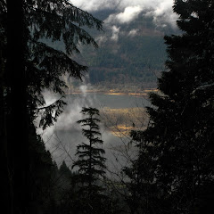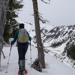
Ah Newton Creek, the infamous Newton Creek that hasn’t allowed me to do a loop that I’ve been wanting to do in the winter for as long as two years now? Anyway, this is not yet another attempt at that loop. It’s another loop in the area that I did long time ago that is also very nice and includes some backcountry navigation. The route is pretty much the same as before heading towards Newton Creek but then, instead of crossing it, we followed a path uphill on the west side of the creek. This path meanders thru the forest with several openings offering clear views of Mt Hood (although it was hiding from us on this particular day). We followed this path to a point where you either veer of a bit and climb on a ridge or get deeper towards the Newton Creek canyon. Since I didn’t want to cross Newton, we opted for the first choice. And I have to say that is if probably the second best part of this loop. There’s no actual route but you are following the spine of a ridge with deep valleys on both sides. To your right is Newton Creek and to your left is Clark Creek. This ridge tops of at some point where you leave the forest behind and are welcomed by great vistas. Trying to avoid crossing a creek, we continued up until we found a covered spot over Clark Creek to cross and then do the hard climb up towards a parallel ridge on the west slope. From there you can see some of the lift lines in Mt Hood Meadows and several ski tracks left behind by some valiant backcountry skiers… or just lost skiers. Then came the best part of this route, going down on a ridgeline with clear views to the south that, on clear days, includes Mt Jefferson and Three Sister. Eventually the trail crosses the Newton Cree trail which you can’t miss if you are going down. Despite the fact that we didn’t get to enjoy a clear blue sky day, we certainly enjoyed the workout, the views and the route
Interactive map
To see the full map, click Menu and select Full Screen. You can also click Terrain to change the map style