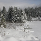
Wahkeena – Multnomah Falls Loop, Dec 12th

Is not like I haven’t done this loop or trail before, I think by now I could do it backwards with my eyes closed, but with the couple of unseasonable cold weeks we’ve had, I knew the water falls were frozen or nearly frozen. With the mild winters we get in Oregon, frozen waterfalls are not very common, so this was an opportunity we couldn’t miss. Besides, I was not leading the hike, Gregg, a fellow hiker wanted to make this his first qualifying hike to become an assistant organizer in the group so I was just tagging along. Instead of leaving the cars at Wahkeena, we decided to park at Multnomah. Before heading out and doing the short connector trail to get to Wahkeena though, we went up a bit to take some early pictures of Multnomah, just in case weather got worse. From this moment on, we were just amazed by the beauty of the streams and waterfalls. The combination of running water and ice formations was incredible. The other thing we noted was that, as water freezes and turns white, little water trickles that you rarely see, form big ice sculptures around rocks and plants. On of these was the trickle on the way to Wahkeena. In the summer you can only see small drops of water sliding on moss. This time, we found a huge ice formation, large enough that there where a couple of ice climbers climbing it. Son after we got to the Wahkeena trailhead and another surprise. The creek was partially frozen but still with a lot of running water which made the ice transparent and even shiny.

Wahkeena Creek


The hike from there was, as expected, a bit tricky. On the way up, we had to pass several sections of the trail that were completely frozen. Having traction devices and poles did help a bit though. As we were gaining elevation, there was more ice but still the water was running underneath. At some point we crossed a small stream that had only a couple of holes here and there were you could see water rushing.
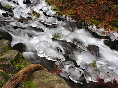
Water under the ice


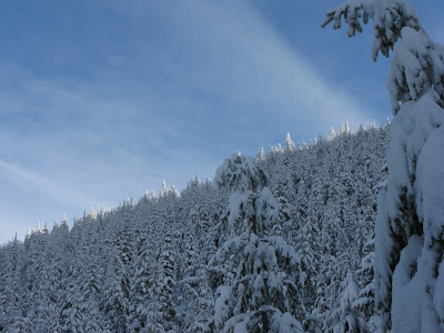
Strangely enough, once we got up to the basin, there was no snow or ice. It was like winter was not happening in a big are of the forest. Then we started descending the Multnomah creek and to the most interesting part of the hike. This loop can be done clockwise or counter clockwise. Although clockwise gives you a nice view of the waterfalls as you approach them, doing it counter clockwise as we were doing it, is more impressive as you approach the waterfalls from the top. As we were descending, the first waterfall was Ecola. It was partially frozen but still running. Then came Weisendanger, the big waterfall that I’ve captured many times before. This time though, the waterfall had a partial ice cover on one side. Despite the force and the amount of water coming down, it was incredible to see this veil of ice just barely holding on top of it. This scenery made the trip for me, it was just incredible.

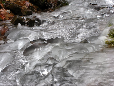
Weisendanger Falls under the ice veil


Then we got another surprise. A much smaller fall (that I can’t find the name) was completely frozen. The interesting thing was you could actually see movement under the ice, so we knew water was running. The really cool thing was that, since it was completely covered, there was no sound at all. The waterfall was totally silent. From there it was just more downhill and more ice until we got back to Multnomah falls. By that time the weather was turning on us and it was starting to rain again. With temperatures near freezing, that meant freezing rain, so the drive home was not a lot of fun.

Ghost Ridge, Dec 5th

With the snow already here, I wanted to take a small group to a nice snowshoe near MT Hood to a place called Ghost Ridge. Originally I had thought I hadn’t been there before, but as soon as we got to the ridge, the views and surroundings became very familiar. I was pretty sure then that I had been there but couldn’t remember when or with whom, although I can remember it was not in the winter. The snowshoe in itself was not very exciting although the rewards were very good. For the last couple of weeks, it has been unseasonably cold in Oregon with temperatures barely reaching over the freezing line in Portland. That, plus the fact that we didn’t get precipitation at all, meant very consolidated, hard, packed snow up in the mountains. We did use the snowshoes but mostly for traction rather than to float on snow which made the hike very noisy. Ghost ridge is a small peak off trail from the PCT. It can be reached from both, the Barlow Pass Sno Park or Frog Lake. I decided on Barlow knowing it would be a bit easier. After meeting at the trailhead, and gearing up for the very cold day. We headed out on the PCT towards Twin Lakes. At about a mile in, where the trail veers to the side of the mountain, I started to look for a good place to go off-trail thinking I would have to navigate to the ridge. With the lack of new snow, there was no need to navigate. Very soon we found a user trail that was very easy to follow all the way to the top of the ridge. The views were very good but not fantastic. The cloud cover was low enough to cover the mountain and there was enough wind to make it really cold. We continued on the ridge for a little while until we found a sheltered area to stop for lunch. From there we continued down the side of the ridge until we realized we were o the wrong side. After a quick adjustment to our bearings, we climbed back to the ridge and then hiked down until we got back to the PCT. I can’t say it was a great snowshoe outing although it was interesting.

Mirror Lake & Tom, Dick and Harry, Nov 21st

This is one of those classic hikes near Mt Hood. In the summer, on a clear day, you can get the full reflection of Mt Hood on the lake (hence the name) and you can climb to Tom, Dick and Harry for some spectacular, up close views of the mountain which can include views of Mt Jefferson and Three Sisters. About two years ago, the Oregon Department of Transportation, decided to stop cleaning the snow that gives access to parking for this hike. Since then, the only option is to park at Ski Bowl and either follow the road, which is not very nice or, find your way thru the forest using a GPS or navigating with map and compass. I did this hike about a year ago (the backcountry option) and it was not easy as there are more than a couple of creeks to cross. This time, Jeff wanted to establish a more direct route to the lake, so we embarked in this adventure. Instead of following a straight line, as I did last year, to the trail and then hike the trail up, we took a bearing from the parking lot in a straight line to the lake. The route was much shorter but with more elevation gain. Soon after we started, we found our first obstacle of the day. We had to cross a big creek and after looking for a tree to use, we ended just walking on water on a shallow area.

Linda and Brian crossing the creek


From that point on, the hike took us through some dense forest, deep snow and about 7 more creeks to cross before getting to the lake. During this portion of the hike, the sky was completely covered with grey clouds which gave the whole area a nice cold wintery touch. That lasted until we got to the lake though. As soon as we found the trail and started circling the lake, it started clearing up a bit. After going around the lake, we found a nice spot for lunch so we took a well deserved break. Since some people needed to return early, we decided to divide the group. About half the group went straight back while the rest continued the hike up to Tom, Dick and Harry. The hike up was a lot easier than the first portion as we were following a well marked trail that took us around the ridge to the top of the mountain. Going around the ridge gave us some magnificent views of the valley and highway 26 down bellow and some partial views of Mt Hood. As we were hiking up, the sun was already heading down so light was barely coming over the ridgeline.

Light over the ridgeline


After a while, we finally made the turn towards the summit on an even easier trail. Shortly after, we were at the top been blown away. It was very well worth it though as the sky had cleared a lot and the views were amazing. Not only we had Mt Hood clearly in front of us, but to the South we could see Mt Jefferson and also the Willamette valley to the west. We stayed there for a while, and as long as we were able to bear the wind, then, it was time to head back. The hike back was uneventful for the most part and since I was leading now, I decided to take the trail to a much lower elevation and then cross back to the parking lot. This made us hike the last portion in the dark while navigating with map, compass and headlamps. Fortunately all in the group were very well seasoned hikers so it was a lot of fun.