Bald Butte, May 11th

Not to be confused with Bald Mountain, which is also located in Mt Hood but on the north west side, Bald Butte is one of the high points on a small ridge on the east side of the Hood river basin. I didn’t know anything about the existence of this trail until I went to a presentation about a new hiking book at the Mazama Climbing Center. In that presentation I learned about this usually missed hike which, according to the author, can challenge Dog Mountain when it comes to wildflowers with the advantage of very little or no people. That by itself was reason enough for me to go explore the area. Getting to the trail is fairly easy and even though it has very few parking spots, it’s not much of a concern as not too many people go there. The trail starts going thru some heavy bush but quickly gets to an open spot that gives you a taste of what’s to come. From the trail you can clearly see Parkdale, the upper Hood River Valley and obviously the northeaster side of Mt Hood. The view at this point is pretty spectacular. Continuing up, the trail leaves the heavy and uninteresting bushes and becomes a more open trail with wildflowers and low bushes. Most of the trail faces south but every so often it will pass the ridge to the other side where Bald Butte becomes clearly visible. Once you think you’re done huffing and puffing, you get to a T junction with the Surveyor Ridge trail. As planned, we turned left here and headed towards Bald Butte. About half way there, we came to an opening where an access road reaches the ridge. We learned that this entry point is normally used by mountain bikers and motocross bikers to access the same trail. Also, from this point, the trail becomes a service road that reaches the power line. From the distance you start hearing the buzzing of the electrical lines which only grows louder as you get closer. Right under the towers, there’s a small open area that looks like a parking lot with very nice view of the valley and Hood. From that point, the trail goes up again and leaves the power lines behind. Towards the end, the trail comes to an opening with probably the best view. As you look up towards your destination, you see the road, and a field covered in yellow wildflowers resembling those manicured background pictures we have on our computers. The trail doesn’t end at the summit of Bald Butte but this is a very good destination for views. From what we could see, you can continue forward dropping sharply to regain elevation at the other side. After a nice lunch with a view, we headed back and once we got to the T junction, we decided to explore the other side for a bit. For the most part it was not very interesting as the trail was navigating thru a dense forested area. Once we reached a butte with no name, we noticed a user trail towards the west to what seemed to be another view point. We followed that path and got to a small open area with some rock formations and steep drops. Views from this point where just as good as those from the trail. We took a second short break and then headed back down the way we came.


Interactive map

To see the full map, click Menu and select Full Screen. You can also click Terrain to change the map style

North Lake via Wyeth Ridge, Apr 27th

Somewhere in the back of my mind I had the idea that I had done the Wyeth trail before. For some reason, that recollection also told me that it wasn’t a very interesting trail. I did remember that it was not easy. Well, I found out I was wrong in all counts except for the difficult part. I certainly recall doing part of this trail but at that time we didn’t reach the lake or any of the amazing viewpoints on the way. This time, with more time and stronger hikers, we did the entire out and back route North Lake and were surprised, not only by the destination, but also by the route. The first part is as any other Gorge trail; you climb quickly to the power lines, cross under them and then, start heading up. For a while, the trail doesn’t offer any views, it’s just a very forested path with tall trees that mask the sounds of the highway only enough to give you an idea you’re out there. After some huffing a puffing and several switchbacks, some views start appearing thru the trees. The first one was a clear sight of Mount Saint Helens on the other side of the river. Higher up, the trail gets to the ridge and skirts on the western side with open slopes overlooking the Columbia River and the Harphan Creek drainage. As if this is not interesting enough, wildflowers in this area are just magnificent at the right time. On our hike we saw a large variety that included wild orchids and lilies. Then, it was back to the hard, steep climb thru the forest. At some point we hit snow and following the track became a bit more difficult. For a moment we veered too much to the east and ended walking on slushy snow over Lindsey Creek which, according to the route I had was my limit. Once I realized that, I shifted direction going straight for the lake. Getting there was one of those wow moments where you see there’s a viewpoint, you know the views are fantastic but you don’t see them until you’re standing right there. When we got there, the sun was hitting that side of the lake so there was no snow making it a perfect spot for lunch and well deserved rest. I did take my time taking extra pictures of the lake while the rest enjoyed sunbathing on the rocks. Our return was following the path all the way down to the car which was as enjoyable as going up… minus the huffing a puffing of course.


Interactive map

To see the full map, click Menu and select Full Screen. You can also click Terrain to change the map style

Rudolph Spur from Herman Creek, Apr 20th

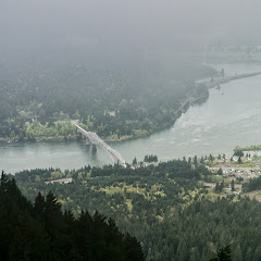
I must say that this is one of those routes I do love doing, even when I get a bit disoriented, loose the trail and have to find my way around. And yes, despite the fact that I have done this trail several times, every now and then I manage to go in the wrong direction. This time though, instead of starting from the Bridge of the Gods parking lot and hiking up towards Dry Creek Falls, I decided to start from Herman Creek. The only reason for that was to add a couple extra miles to the loop and some trail I had not done before. Leaving from the Herman Creek campground, the first part of the hike just follows the same route for Herman Creek but soon after passing the power lines, a trail sign shows the path of a shortcut towards the PCT. That path meanders thru the forest for a bit on an area that, even though is pretty close to the highway, is very secluded. We found several smaller streams with hidden waterfalls on this route that looked pretty nice. Then, after a bit over 3 miles, we reached the bridge over Dry Creek. We took a short break at this point and considering we had a long way to go, we opted for not doing the side trip to Dry Creek falls. Then we left the trail behind and started following the very faint path up Rudolph spur. Weather was not cooperating much so we did navigate a bit in the fog and at some point I made a wrong turn that thru us way off the path. After realizing my mistake and making corrections, we managed to bushwhack our way back to the faint trail and finally reach a viewpoint with open vistas of the Bridge of the Gods. To our surprise, we found a large group of oriental people resting and having a bite to eat at that spot. While taking our break, we learned they took the route we did and got there before we did which, to an extent doesn’t mean much until you consider how young they were. One woman we talked to was over 70 years old! And the youngest was easily over 50. If that wasn’t impressive enough, after taking some pictures, they continued up towards Benson Plateau and disappeared in the mist in almost no time! Obviously any comments of being tired vanished from our thoughts at that point. Then we continued up towards the Plateau where we found some snow and a very foggy forest. At a point, I got the feeling I was again going in the wrong direction and to our surprise, and rescue, we crossed path with the same group again… all happy and having the best of times and no sign of being tired. After exchanging some direction we finally made it to our trail and continued our loop towards the PCT. Finally, once we had lost some elevation it all became much easier and we were able to enjoy some scenery as we completed the loop going back to Herman Creek. If anything, we learned on this trip not to complain about our age!


Interactive map

To see the full map, click Menu and select Full Screen. You can also click Terrain to change the map style

Indian Point, Apr 14th

Indian point is one of the many destinations in one of the many trails near Herman Creek. It is a prominent rock that opens up to the gorge inviting you to do things you shouldn’t do… or, you should know how to do. If you look at pictures of this feature (I was not able to take pictures myself because it wasn’t clear enough) you’ll see it’s a rock formation that seems easy to climb onto. Problem is that it’s completely exposed and usually very windy. Falling from there would not be nice. Still, it offers several ways to hike in the area. Certainly you can go straight to it and then retrace back or, you can take any of the trails in the area and do a loop. Val and I decided to do a loop and keep it low to avoid going thru a lot of snow. So we started from the Herman campground reaching quickly the power lines. From there, we continued up to a big junction where the Gorton Creek trail and Nick Eaton Creek trail meet. The Gorton creek trail goes directly to Indian Point and then continues climbing on the ridge. The other way climbs steadily towards Nick Eaton and then pretty much shoots straight up on a series of switchbacks. On this trail, there are several connector trails that will take you to Gorton Creek trail. We took one of those and quickly entered the snow. For just a bit we lost our bearings and noticed we were going the wrong way. A quick correction and we got back on track and started descending on the other side on lingering snow. Finally we got out of the snow roughly at the switchback where a user trails leads to what looks like a vertical drop-off. On clear days (and good conditions), you can follow this trail to Indian Point and maybe climb the rock. So far it’s been three times I’ve been in the area and still haven’t seen it… I guess one of these days I’ll get the opportunity


Interactive map

To see the full map, click Menu and select Full Screen. You can also click Terrain to change the map style