Bikepacking the Lower Deschutes, Apr 23rd

Bikepacking is something I’ve wanted to do for some time now. Basically the idea is to combine backpacking with mountain biking. It’s not just putting your pack and getting on your bike (although some people did it that way) but strapping the gear to the bike and then heading out. The advantage of this is that you can cover more distance and/or enjoy the trip in a complete different manner. I got the first idea when I saw some people doing just that up in Lopez Island on one of my trips to Orcas. But then, while doing some research for this trip, I learned that there are a lot of people that do it, enough to actually give it the bikepacking name. Just to give you an idea, the only thing I had in my back was my small hydration pack, the rest of the gear was on the bike. It looked something like this

My fully loaded bike


This particular trip spawned from a discussion with Gordon. We both thought that doing the Deschutes this time of year would be perfect. Not only we would be ahead of the rafters that navigate and camp on this river but also we would get the best weather. Earlier in the season you run the risk of really cold nights and maybe some showers and later in the season of extremely hot days, this is the high desert in the end. The only thing that was keeping us from doing this trip was that it’s a long, arduous and unprotected trail (the trail follows an old rail bed), not very friendly if you want to walk the whole thing. So the idea of biking it came along and here we are.
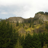
We decided to start Later on Friday so after a nice lunch at a Mexican restaurant we found in The Dalles, we drove to the campground and got our gear ready. We didn’t know that we needed to ride back to the entrance to get on the rail bed so we started riding south from the parking lot on the river trail. Obviously we found this trail to be hike friendly but not bike friendly as we ended up doing a bit of bike-bushwhacking on the way. So as soon as we found a side trail that would take us to the actual rail bed, we took it. Unfortunately, it wasn’t a rideable trail so we had to carry our bikes and gear up the hill. It wasn’t that bad, but it certainly got our hearts pumping. This side trail got us to a rock formation with a little arch on the side of the river but it also gave us a nice glimpse at the canyon ahead of us. By this time, not only we were far enough from civilization and noise, we were alone in the trail.

View of the Canyon ahead


Now on the rail bed, we continued south and, as you’ll see in the pictures, the trail doesn’t change much although the scenery is always changing as you go thru meadows and rock walls following the river Canyon. Along the trail you also find a lot of little pieces of history about this place which makes the whole trip a lot more interesting. The first thing we found was a rail car that might be over 100 years old. It was quite incredible to see that it is in pretty good shape despite being in the same place for so long. I guess things in the past were well constructed. It was also interesting to see some wildlife using the car as shade or shelter. I was able to take a good picture of a little lizard that was sun bathing around but the little wild rabbit under the car was to shy for that.

The first rail car


We continued the ride passing by a second rail car that wasn’t in as good of a shape as the first one and some old farming equipment. Soon after that, we got to Fall Canyon, the campsite next to the river that we had picked up as our overnight resting place. Since we still had a bit of light after setting up our tents, we took a short trip further south to check out the Harris Homestead. This is quite a sight as the homestead was build over 100 years ago and it’s still partially standing. In it, you can still see signs of how life was back then. An old stove with a pan is still there as well as the remaining springs of an old mattress. Most of the walls are covered with old newspaper dated back to the 1890’s and some fabric, probably from old curtains is still visible. It almost felt like they left on vacation and never came back.

The old Harris Homestead


Our plan for the second day was to ride as far as we could, potentially to Mack’s Canyon at the end of the trail. After a nice breakfast, we took of riding south and passed the Homestead one more time. Right after it, there’s an old ranch, probably part of the same property. Although it looks much newer than the Homestead, it clearly dates back more than a couple of decades. Not too far from it, we got to the old water tank, another time mark in the trail. Most people that come visit this trail turn around here. After passing the tank, despite the fact that we hadn’t seen anybody else on the trail, we felt the trail to be even more desolated. As we continued, we passed numerous rock walls and meadows and more than a couple of times we had to stop to admire and take pictures of the wildflowers. I could try to put some of that in words but this time I’ll let the pictures do the talking


Obviously trails come to an end at some point. In our case, we got to a place where there was an old trestle but not anymore. Continuing on the trail would have required carrying the bike down a ravine and then up on the other side which looked like quite the workout. Without knowing what we would find after that, we opted for the easier choice of stopping there for lunch before heading back.
Once back at the old Water Tank, we took a detour on a very faint old road up Harris Canyon. We were on the look for another old homestead in the area that burned down not long ago. I couldn’t say we found it but I couldn’t say the opposite either. We did find some old roof panels and some rusted metal but that was it. At some point the grass got high enough that riding became hard so we left our bikes and continued on foot. To get a better view, we hiked up to the ridge overlooking Mays Canyon and Harris Canyon but did not see anything. Well, We got an incredible view of the river and surrounding canyons, but nothing of the old Mays Homestead.

Overlooking Harris and Mays Canyons


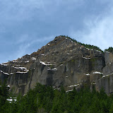
Sunday was the day to ride out. With a full day ahead of us and only about 10 miles to the trailhead, we were open to side trips. One that we had thought about was the Rattlesnake Grade. This is an old road that climbs steadily for almost 2 miles to the top of the ridge, roughly 1600’ above the river. So we rode past the second rail car to an old Trestle that is barely visible on the way in; explored around it for a while and then started riding up the grade which is just across from the Trestle. A bit further Gordon and David decided to stop and maybe explore on foot as their legs were not up for the challenge. Mark and I, on the other hand, got or gear of the bikes and continued up. I will not say the ride was easy, it was not, but the rewards were worth it. AS the road climbs and snakes we got several views of the river bellow us. At some point you get high enough that you see over the ridge on the other side of the river and Mt Hood starts to peek in the distance. That little view fueled me to continue all the way up until the road meets a closed gate. We left our bikes there and continued on foot to the end of the ridge which offer the view of the canyon bellow us, Mt Hood in the distance, the wind farms towards the Northeast and Mt Adams, further away.

View from the ridge


Yes, the ride down the grade was a lot of fun! 2 miles with 1600’ of elevation gain go by pretty fast. On our way back, we stopped one more time by the old rail car for a light bite and then we headed out. Certainly it was a change in scenery for me as most of my hikes have been in deep forests full of tall trees but considering the majority of Oregon is high desert, it was just a matter of time until I started exploring these areas. I also learned about a new outdoor sport which is very likely I will try again.

Archer and Hidden Falls Loop, Apr 17th

Another epic adventure. This is an area I discovered by accident while researching for another hike. Back then, when I found it, I did a small loop and was able to find Hidden Falls, but on that occasion, we only saw archer falls from the top of the rim. This time, I wanted to go to the base of the waterfall not only because the fall itself is incredibly beautiful but also to check out the two gigantic basalt formations in front of it. So, as I did last time, we started from the lower Valley (sometimes referred as Happy Valley for a hippie community that lived here some years ago) but instead of crossing the creek and scrambling up to the Eastern Ridge on Archer Mountain, I decided to take the group forward following the creek to the waterfall. I wasn’t sure I was going to find a way to get to the ridge from that point, but it was worth exploring. The hike on the creek turned to be very interesting, not only because well, hiking next to a creek is always beautiful as you see multiple tiny waterfalls and ponds but also because, on this particular case, the water disappeared in some sections and reappeared in others. After a while finding our way thru the bushes, we finally came out on the upper valley. From there, we continued hiking on scree and talus towards the fall which we finally reached. At that point it didn’t seem there was a way to go around and climb to the ridge but Pete, trying to explore a bit more, decided to climb around the waterfall and get in the cave behind it. I followed and as I was climbing, I noticed that, following the top of the talus, it was possible to reach a forested area and from there bushwhack our way up to the ridge. This section was not very easy as every step made something move, but once we got to the forested area, at least we had trees to hang on to. Being a bit tired already, we made a quick lunch break and then headed up on a very faint, old logging road I had found the previous trip. From that point on, the trip was pretty much the same as the other time so I knew where I was. We continued up until we reached Hidden Falls which, with less water than the first time I went, allowed me to go lower and much closer to the base for some nice pictures. As you’ll see in the pictures, we had a small accident at that spot as Pete dislodged a rock that fell on my while Michelle was trying to stop it. It wasn’t much but Michelle got a bruised finger. After that, we followed the road for a bit and then veered off on a faint foot path that eventually met with the ridge trail that comes out at the top of the rock wall where the cross is. The group got a bit skeptical at that point as we were a bit high and it didn’t seem that we were going to get back down in time. What they didn’t know is that the trail descends very quickly. In the end, we all made it with some scratches and bruises, but we got to see a waterfall most people don’t even know about.

Trail of Two Chiefs, Apr 11th

This trail, also known as the Greenleaf Falls trail, is located in the Washington side just south of Table Mountain. For those in the area, Table Mountain is in the list of hardest hikes in the Columbia Gorge as it is both long and steep. This mountain, which looks like it was cut from a much larger mountain, is the result of a massive collapse that formed what is known as Bridge of the Gods. The Trail of Two Chiefs is a little known trail that circles the valley right at the foothill of Table Mountain offering great views of both, the mountain and the river behind it. The hike itself, although easy as it follows an old ATV road, requires a bit of navigation as several other trails, including the PCT cross it at some point. The hike starts with a soft climb through a dense forest until you get to Carpenter Lake. If the name tells you that there will be water to see, you might be setting yourself for disappointment. Carpenter Lake happens to be a very shallow, frog infested, swampy meadow. There’s no water to see but you can definitely hear the frogs. From there on, the trail opens up a bit and soon you start following the talus slope of Table Mountain. If you are looking for it, about half way up, looking through the trees, you might see two tall rock formations up in the ridge. These are the Two Chiefs, Sacaquawea and Papoose. Shortly after that, you come out of the forest to an open area with an incredible view of the mountain on top of you and an open vista of the Columbia River. Being a sunny, warm day, this seemed like the perfect stop for lunch. About half a mile ahead, the trail ends at Greenleaf Falls, a very chaotic creek that has washed out part of the mountain. You could continue on but that would require getting your feet wet, so we decided to stop here, take a bunch of pictures and return the same way we came. Perfect short hike for a Sunday.

Clear Lake Butte and Little Crater Lake, Apr 10th

You might remember I tried this same route back in February on a very cloudy day. That time, we were notable to do the intended route for several reasons. With much better weather and having a bit more information (and longer days), it was time to try this one more time. This time the snow, near the parking lot, was very consolidated almost to the point that we didn’t need the snowshoes. That worried my hikers as they thought we would be just hiking on a thin layer of snow. I have to admit I was a bit worried as well as I didn’t know what was ahead for us. Luckily, once we got to the point where we needed to get off trail, the snow was much better so we got our gear on and headed up the mountain. Contrary to last time, I kept the group on a straight line up to the top so we got to the Fire lookout tower without many incidents. As you can see from the pictures, the views were much better than back in February. From the tower it was easy to see Timothy Lake, Mt Hood and Clear Lake. Unfortunately someone was occupying the lookout tower so we were not able to go all the way to the upper platform for the best views. It was also very windy, so being up there was not easy.

Clear Lake Butte Fire Lookout Tower


We took shelter inside the wood storage which ended up being a perfect spot for lunch. After that, it was a straight line to Little Crater Lake. Although this route was all downhill, with warmer weather the snow got stickier so the hike ended up being quite tiring. Eventually we got to the road that goes around Clear Lake Butte and found the fork to Little Crater a few yards away. That portion was a flat road so it actually served us to rest our legs for a while. The Lake, as expected was very small, but what’s incredible about it is that it seems to be carved out of the rocks. Looking at it, you can see kind of a round platform around and then a big hole in the middle. There was a sunken tree in it that was barely visible but you could make that the lake in fact is very deep. The other interesting thing about this lake is that, since it’s so deep, it rarely freezes.

Little Crater Lake


After enjoying that scenery, we had the hike back to the car. The only issue with that was we were still about half way thru our hike! Looking at the map, one option was to climb back up and come down on the other side of the butte on a shorter route, or do a longer route around. Since we were pretty tired but didn’t want to spend too much time getting back, we opted for a half way up and around combination. That decision didn’t make the hike back any easier. As we were traversing the slopes of the Butte, we were sinking to our knees every other step so half way thru we veered off to get back on the road a bit earlier than planned. Eventually we got there but were very tired so we took a short break before doing the last 3 miles to the car.