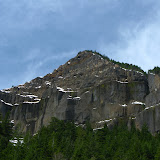
This trail, also known as the Greenleaf Falls trail, is located in the Washington side just south of Table Mountain. For those in the area, Table Mountain is in the list of hardest hikes in the Columbia Gorge as it is both long and steep. This mountain, which looks like it was cut from a much larger mountain, is the result of a massive collapse that formed what is known as Bridge of the Gods. The Trail of Two Chiefs is a little known trail that circles the valley right at the foothill of Table Mountain offering great views of both, the mountain and the river behind it. The hike itself, although easy as it follows an old ATV road, requires a bit of navigation as several other trails, including the PCT cross it at some point. The hike starts with a soft climb through a dense forest until you get to Carpenter Lake. If the name tells you that there will be water to see, you might be setting yourself for disappointment. Carpenter Lake happens to be a very shallow, frog infested, swampy meadow. There’s no water to see but you can definitely hear the frogs. From there on, the trail opens up a bit and soon you start following the talus slope of Table Mountain. If you are looking for it, about half way up, looking through the trees, you might see two tall rock formations up in the ridge. These are the Two Chiefs, Sacaquawea and Papoose. Shortly after that, you come out of the forest to an open area with an incredible view of the mountain on top of you and an open vista of the Columbia River. Being a sunny, warm day, this seemed like the perfect stop for lunch. About half a mile ahead, the trail ends at Greenleaf Falls, a very chaotic creek that has washed out part of the mountain. You could continue on but that would require getting your feet wet, so we decided to stop here, take a bunch of pictures and return the same way we came. Perfect short hike for a Sunday.
1 comment:
Nice review. Nice pictures. Where is the trailhead for this hike? Is it the parking lot across from Bonneville dam on Hwy 14?
Post a Comment