Abandoned church on the road

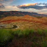
The drive also took us thru wind farms, something I had seen only in pictures before. Really interesting. Then we got to Fossil, a little town that marks kind of the entrance to the John Day Fossil beds where Painted Hills is. From there it took us about half an hour to get to the campground and drop our stuff. Knowing that the weather didn’t have the intention to play nicely over the weekend, we decided to make a run to the Painted Hills viewpoint (an hour away) to take pictures at sunset (that was going to be the only opportunity for that). So I drove like crazy, or that’s what people said, to make it on time. Big surprise, as you approach the area, the first thing you see are this hills that are completely arid and red. On the other side of some farm land, the hills had red stripes in combination with some black marks. All that was just the beginning though. Once we got to the viewpoint, the whole Painted Hills basin came in to view. Truly amazing scenery that I will let a picture explain.
The Painted Hills Basin

We stayed there for a while waiting for a sunset that was no big thing before heading back to the campground. That night, during dinner, Laurie started a discussion trying to arrange plans with the multiple options available. I had already researched a couple of mountain bike trails and discovered that I could link two of them for a long 35 miles loop. Originally I had plenty of takers on the idea but only Michelle was up to waking up early to tackle the long ride. So on Saturday, we woke up early as planned, had breakfast and headed out back to the painted hills. We did this second drive there at a much slower pace to enjoy the scenery which included views of the canyon as we drove to the ridge, some bare sections of the mountain with mineral deposits that gave them distinctive colors and some interesting farmland. Then we got to the parking lot, got our bikes and without hesitation, started our long ride. The first portion of the ride was going up the Burnt Ranch road which crossed the area of an old farmer ranch that was burned to the ground by Indians (yes, cowboy movie style). The land is still private and there are some farms that still carry the same name. It was quite interesting the scenery as it included some old buildings, new machinery, old signage, green fields and bare rocky cliffs. The road continued to the end of the ranch where it changes names to the name of the next ranch. Once we got on the Cherry Ranch road, we found a not so inviting sign but decided to keep going. Not only the area was desolated, but the ride was interesting to say the least. The road curves and goes up and down hills as it crossed several hills, canyons and slopes. In the pictures you’ll notice that, although the scenery looks similar, each turn and portion of the road looks completely different from the previous one making you think you are riding miles and miles.
One of the many turns on Cherry Ranch

We rode on this road for a while passing near the John Day river again and then veer off. As time was passing by and we were just getting farther away, we made a stop for lunch at one of the few spots with some shade before heading back. We retraced our way back to Burnt Ranch and then took the side road around a butte towards the River to complete the second part of the ride. What we were not counting on was a steep incline right after the fork. Although that was a hard one, the payoff was spectacular. After a turn, the road was all downhill curving towards the Priest Hole, a small boat lunch in the John Day River. On this section, not only we had the views of the river, we also had another section of painted hills across that were equally impressive. We made a quick stop at the Priest Hole and almost jumped in the river to refresh before riding back to the car. Obviously all that beauty had to come at a price which we had to pay just minutes before getting to the parking lot. As we were riding the last mile, a truck with cattle drove by us without stopping. Yes, we were submerged in dirt and the beautiful smell of cows for a while. For the rest of the day, we first drove to Mitchell, a little town nearby before heading back to a fabulous potluck back at camp.
For Sunday, Laurie had arranged a guided hike thru the painted hills. After breaking up camp and driving back to the Painted Hills Unit for the third time, we divided the hike and the group in two so we could do both loops. We took off from the park entrance hiking on the road towards the trailhead. On this section, one thing that was noted was the little yellow flowers that appear just for a couple of days. AS this play is very dry, all plants will grow only where there’s water. Since most of the hills are just mineral deposits, the water runs off on little creeks disappearing almost instantly. If you are lucky to be there when the flowers bloom, you’ll notice all the lines in the hills painted yellow adding to the beauty of this place.
Little yellow flowers on the hills

On our group, we did the Carrol Rim hike first which took us to the top of a mountain on the side of the basin that overlooks the entire Painted Hills units. It was a nice short hike with wonderful views at the end. The second part was by for more interesting as it included a behind the scenes loop in an area you can only go with guides. On this second loop we got to actually walk on the hills and get a real close look at the terrain and all the little things that grow there. I guess we were just lucky not only because we saw the little yellow flowers in bloom but also because we were in time for the Bitterroots and Hedgehog Cactus flowers. Those, in contrast with the arid setting were fantastic. In the rest of the pictures you’ll plenty of views of this amazing and unique place.
