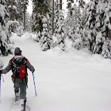
This is one of the classic snow shoe routes up in My Hood. In the past, all the times I’ve done this route, I’ve started from the Snow Bunny Sno Park and done an out and back which covers probably the more interesting part of this trail. But, if you look at a map, you’ll notice that this trail is a lot longer giving the ability, by connecting with other trails, to do a complete loop. I have already explored most of the connecting trails in the White River Basin and Barlow Pass area so I wanted to check the portion between Timberline Road and White River. Since this would be a long day if you wanted to come back, I decided to plan this as a car shuttle leaving half of the cars at the exit point in white river and then parking the rest at the entry point in the Summit Ski area. After all that logistic, we finally hit the trail at around 11AM on a mild day with good snow. The first portion was easy to navigate as I was following the tracks of someone that was ahead of me. I learned quickly that whoever it was, it was not going to the same place I was going so at some point, I had to correct and start navigating off-trail thru the woods. The group was doing very well although some started to show signs of being uncomfortable which irritated me a little bit. I can understand as a lot of people don’t feel comfortable not knowing where they are going or how long will it take to get there. As we were navigating thru the woods, we had to cross several small creeks that were not completely covered with snow. That was the first sign that we didn’t have enough snow on the ground yet. About two hours after we started, we finally found the road that you take if you were to start from Snow Bunny. This was obviously a relief to all as, among other things, I knew the trail very well from that point on. We made a quick stop for lunch under the trees that was cut short as it started to snow a bit. Then came the marching part. One of the key things about the Yellow Jacket trail is that it doesn’t have a lot of elevation gain but it does have a lot of ups and downs making it relentless. For a couple of hours we just marched on until we reached a traverse section that then descends steeply to the creek below. In normal snow level, the creek is completely covered to the point that you can’t identify where it is. This time though, it was clear to us where it was. While looking for a good crossing, I felt into a big hole almost to my shoulders which wasn’t that bad until someone else fell besides me and sink just as much. I was able to get good footing and get out and then had to get the other hiker out. Clearly that was not the best place to try to cross. We hiked upstream a little bit and found a bent tree spanning across the creek. As you’ll see in the pictures, it was an interesting way to cross. From there, we had to just keep a good pace as it was getting dark fast. Finally we made it to the parking lot just in time to get in our cars before it started snowing really hard.
You can check the pictures
here
No comments:
Post a Comment