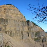
This was another one of those really long, hard and very rewarding hikes. Not only is a lengthy trail but it is also very steep. Table Mountain, as you might imagine is a mountain with a flat top, but that’s not the most interesting feature. It is located on the Washington side of the Columbia River Gorge. The south face (towards the river) is a 2000’ vertical wall that was formed when the mountain collapsed. All the debris from the mountain formed a stretch of land that for some time stopped the Columbia River forming a natural bridge that the Native Americans named Bridge of the Gods. In that stretch is where the bridge with the same name is today. Being a very long hike, we decided to start really early so we got to the trail head right after sunrise. The trail took us on the same path I had done just a couple of week ago when I went to Gillette lake and the Greenleaf Overlook so the first part of the trail was very well known to me. After walking in a relatively easy slope for about 5 miles we got to the trail junction where the “Heartbreak” trail starts. At that moment the name sounded funny but we did learn shortly afterward that is a very appropriate name for this trail. To get an idea, from that point it is a little over a mile to get to the summit but the elevation gain is over 1500’. That makes this portion of the trail very steep. After an arduous climb we got to a ridge that gave us the first really impressive view of the mountain wall right in front of us and the valley formed when it collapsed. From that point on, the trail travels away from the ridge and then turns up again through a steep rocky slope that has to be climbed using both feet and hands. Not long after that grueling section, you reach the summit and descend a bit to the actual peak of the wall. As you can imagine, the views from that point are simply breathtaking, so we decided to stop for lunch. For the return we had though doing the same trail, but on the way back we noticed a second trail on the ridge that continued north on top of the mountain. After a short walk, we came to the other side of the table with incredible views towards Mt Rainier. We continued on that trail that started descending on the east side of the mountain. This trail proved to be as difficult as the trail we used to climb up. For a long time we were just traversing on loose rocks. After that hike down and reaching the main trail (a portion of the PCT) we realized that we were about a mile further north so we had about 6 miles to go to get to the car. That hike down was really beautiful as it offered all the changing colors of the sunset until we got to the car in the dark.
No comments:
Post a Comment