The climbing party

The first part of the hike was very similar to any trail in the upper section of Mt Hood, rocky and sandy with low vegetation. As you climb up, tress become scarce and you get more rocks and loose gravel which makes the hike a bit more difficult. Not only you have to climb up, but you have to avoid sliding down. This first portion was very arid and we found several campsites along the way wherever we saw trees. After a while, we finally made it to the ridge where the hike starts to get more intense. After a couple of hours of huffing and puffing we got to the top of the ridge right where the bottom of Crescent Glacier is. From that point forward, up to Lunch Counter, our destination for the day, most of the hike is on snow and ice, so it was time to try my new MicroSpikes. Walking over ice made the hike a bit more pleasant as it was a lot cooler that what it was going over the ridge. During our climb, we saw clouds moving in and out from the summit offering clear views at times and none at others.
Reaching the top of Crescent Glacier

After reaching the top of Crescent Glacier, we veered east towards Lunch Counter and started looking for some good camping spots. We spent some time setting up camp and resting while trying to acclimate to the high altitude. Although you don’t feel much, the low oxygen becomes very apparent when you kneel and then quickly stand up. It took us a while to adapt to that. Once camp was set, we went on an exploring hike around Lunch Counter. Waling all the way to the East and crossing over an ice shelve with a lot or running water, we got to the Suksdorff Ridge that overlooks the Mazama Glacier and the Ridge of Wonders in the distance. As you can see from the pictures, the views where just magnificent.
Panoramic view from the Suksdorff Ridge

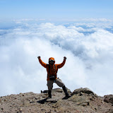
Back at camp, we had a nice dinner and then got ready for a magnificent sunset. By that time, we had rested a lot and happiness was just around us and everybody else in the area. You’ll see a series of goofy pictures that prove the point. Sunset above the clouds was as expected, incredible.
Sunset from Lunch Counter

On Sunday it was rise and shine early in the morning. We had talked about being ready to hike by 7:30 which meant breakfast done and all gear packed. At roughly 8 in the morning we were already on the trail on our way to the false summit first and then the real summit. To Pikers Peak (the false summit), most of the climb is on a glacier which in not as difficult provided you have some sort of traction device. My MicroSpikes came in very handy. It was just a long hike up where you just need to pace yourself so you don’t run out of air. As you go up, the views get better and better. You are constantly surrounded by glaciers, rocks steep inclines and the cloud cover. Once you get to Pikers Peak, you finally get a clear view of the actual summit. From the false summit, the trail descend a bit towards an ice shelve before starting to climb again passing on the upper side of the Mazama and Klickitat Glaciers. The Crevices on the top, up close and personal are just incredible. It’s actually hard to imagine how all that ice is holding in the mountain and not just sliding down. Roughly about an hour after reaching Pikers Peak, we made it to the summit reaching an old shelter. Obviously the first thing you do is just stand there and do a complete 360, I guess is that reassurance that you are there and there’s nothing higher. If you’ve ever been on the top of a mountain, you probably know what it feels like to get there, but if not, you can probably imagine the views you can get from there. Here are just a couple of examples


We stayed at the summit for about 45 minutes until the cold air was getting to us. The hike down follows the same path you use to go up so it’s basically the same views. There’s a highlight though. It takes a bit over two hours to hike up the 2700 feet of glacier from Lunch Counter to the false summit. To get down, you simply sit and slide all the way down… fast…very fast; in fact, it takes about 10 minutes to descent the whole glacier…. Yes, it’s a lot of fun. We did a short stop at Lunch Counter to pick up our gear, change clothes and have a bite before continuing our hike down towards the campground.
No comments:
Post a Comment