The Rogue River Trail, Jun 17th

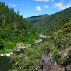
I have to start by saying that changing plans at the very last minute is not necessarily a bad thing. Our original plan for this week was to travel with some friends to Zion National Park in Utah for an epic 6 day trek in the park. For a couple of reasons, we had to postpone that trip for the future. Since Val and I had already taken the days of and had the gear pretty much ready, we started looking for options. Val suggested the Rogue River trail which was also in my list so at the very last minute we packed everything and took of. The drive south is considerably long so we took a leisurely day to drop of the animals, drive there and stay at a motel close by. On Sunday we woke early in the morning, had a nice breakfast and headed to the trailhead which was no more than 15 minutes from where we stayed. From that point we already knew it was going to be a very scenic trip as the river and canyon looked spectacular.


We started on a gentle uphill following the north side of the river and quickly got used to the fact that, for the next four days, we would have the river to our left. You could think that the scenery would not change that much in those conditions. That’s simply not true in the Rogue. Every turn of the river gives you something new. If that’s not enough, there are countless creeks that dump their waters into the rogue so as you hike the trail, you cross numerous very well marked bridges. The other thing we found out pretty quickly is that the trail is inhabited by all sorts of small lizards that run and jump in front of you. It was quite a spectacle hearing and watching them everywhere. Some of them even looked like small dragons taken from a movie or even prehistoric.


The first day, our plan was to get to Horseshoe Bend, a very tight turn in the river, and camp somewhere along the river. When we got there we found a small trail going down to the river and a big area for camping that was already occupied by rafters. Not liking the camp we decided to hike a bit further and look for either a campsite a friend had mentioned or something else to stay the night. We passed a couple of creeks without finding anything until a big opening showed to the left. It was Meadow Creek, one of the hiker only campsites. The site looked almost out of place as it was a big, flat area covered in grass. Perfect for our first night stay.


The following day we woke to a warm but partially overcast day. That gave the river a completely different look. As we hiked we saw the first set of rapids and some rafters navigating the river. But shortly after, we found a side trail going to Winkle Bar. We stood there trying to decide whether to go explore or not. On one side we didn’t know what we would be adding to the trip, but on the other, we didn’t know what we would be missing. So we went to Winkle Bar to explore and to our surprise we found the old Zane Grey’s cabin. It was not marked in the map!. AS far as we were able to find out, Zane Grey was the original owner of the land and lived in his little cabin in the rogue for many years fishing, writing and exploring the river. At some point he moved out and sold the land to the current owners who built a couple of cabins that are still there. Needless to say, the place is beautiful with access to the river and a big meadow that almost looks like a landing strip. It was a little piece of history in the woods.


We got back on the trail and stopped at the next creek for a lunch break watching the river. After that, the trail actually got separated a bit from the river as we were approaching the next piece of history, the Rogue River Ranch. Almost out of nowhere and after a turn, we came to this huge grass covered field with some buildings at the end. The Rogue River Ranch is another place that was privately owned where a small community used to live. It was kind of strange to walk from the woods to something that looked like a well manicured backyard. As we walked thru the property, we did check some of the buildings that are open to the public including a little museum. In it we saw pictures and part of the history of the several families that lived there. At this point the trail is a bit weird so asking for directions; we learned that we were at the boundary between the BLM land and the Rogue River Wilderness land. To continue on the trail we had to hike up to the road and continue on it until it became the trail again. Since it was already mid afternoon, we started looking for a camp at that point. From the ranch we had gotten the recommendation of going past Mule Creek and then looking for a campsite on that side. So after hiking on the road for a while we finally found the spur trail and took it. Just past that point we found a deer enjoying the shelter and shade of a big tree that couldn’t have cared less that we were there.


A bit further down we found the campsite just as the same time as a big group of rafters were unloading. Luckily it was a big enough site for everyone so we took a spot a bit higher to have more privacy. The area was great although very brushy so it took some time to find a god branch to hang food. Later that evening, as we were having dinner and talking to the rafters we learned a different trick to protect the food from the bears so all my effort to get a line for food was gone. Nevertheless, it was cool learning something new and talking to the rafters. They were doing a similar trip as we were but on rafts and what a way to camp that is. They had tables, chairs, a camp shower, a small Dutch oven… even a violin!! That was camping in style I guess.
On Tuesday we woke up again to a beautiful; day with some lingering clouds that were quickly dissipating. Before breakfast, Val and I took a walk around camp and towards the bend of the river were we got a nice view of the river bend were Mule Creek is.


After breakfast and packing our gear we were ready to continue without knowing that we were up to the most scenic section of the river. The rafters had mentioned a bit about it and also recommended us to continue to Flora Dell to camp. So that was our plan when we started. Soon after leaving Mule Creek, the trail started climbing on the side of the river as the canyon got narrower and narrower. The big wide river transformed into a thin, deep channel that snaked thru rock walls. As we continued, every bend in the river offered different views with incredible rock walls on both sides until we got to Inspiration Point. At first we though there was a building of some sort but we were wrong. Inspiration Point is just a viewpoint that looks over the Star Creek Falls on the other side of the river in this slot canyon. It’s a view that is not short of spectacular.


From Inspiration Point, the trail starts descending again as the river gets wider again and you leave the canyon behind. We did see a rafter coming down the channel just before some rapids but then the trail veered of at Paradise Creek and we left the river behind. Similarly as what we saw when we got to the Rogue River Ranch, we got to another big, manicured field with several buildings at Paradise Park. Paradise Park is a privately owned piece of land with a lodge and some other stuff. The weird part is we didn’t see any access to it and there’s some farm animals and machinery. We also saw several lawn chairs all around but not a soul in the area. It was very weird.
After circling the property, we came back to the river just before Brushy Bar where we found a huge campground and the ranger station. It seemed strange again to find such a huge place without big access. Either we had a lot of luck of not seeing to many people on the trail or there was something we didn’t know. In any case, we explored Brushy Bar and went all the way to the river for a lunch stop under the sun with our feet in the water.
After that, the trails levels out as the river continues snaking down. The hills on the sides became smaller and the creeks more sparse. Near camp Tacoma, at Tate Creek, we passed a really nice waterfall hidden in the bushes. A short bushwhack gave me a nice look at it


We continued on looking at all the different rock formations on the other side of the river until we got to a turn on the trail with an even nicer waterfall with a small pool. The water was cold and the pool in the shadow so despite me wanting to jump in, I didn’t. Also, I knew we were close to the campsite we were aiming for but I didn’t know how close or far it was


It was very close. Just after the bridge over Flora Dell Creek, we found a small spur trail going down to the river to a tiny campsite with river access. It was almost idyllic. Besides having space for the tent and direct access to the river, there was the creek dumping its water into a pool next to camp so we had cool fresh water on both sides. Passing thru some bushes and the little stream gave access to the rocky shore of the river with pretty good views to both sides. Certainly it was the best camping spot of the trip and probably one of the best spots I’ve set my tent in. That afternoon we took advantage of the creek to bathe and enjoy the last sunset of the trip


On day four we had a short hike to our exit point. So after breakfast and breaking up camp we continued on our trail with the river disappearing from view and us walking into what looked like farmland. As expected and despite the little nervousness, the car was waiting for us where we had asked for. And just to end the trip on a good note, on the drive home we went thru the coast and stopped at a small restaurant in Gold Beach that ended up being incredibly good.

Mt Defiance, Jun 9th

Being the highest point in the Columbia River Gorge, the Mt Defiance hike is arguably the hardest in the region. A lot of people use this hike for training carrying jugs filled with water all the way to the top. As with other difficult destination, there are several approaches to the summit. From the Gorge, you can climb the Mt Defiance trail or the Starvation Creek trail. An option is to combine these two to do a loop that includes the Summit. Val and I had been training for backpacking and did our first backpack trip of the year but we still wanted a bit more training. The main reason was a trip to Zion that later on got postponed. So we started on a cool, cloudy morning going up the Starvation Creek trail. As expected, the trail just shorts up from the get go and you realize that when, not even half an hour after you start, you already have a nice view of the Gorge. Unfortunately for us that day the views were a bit limited due to weather. After the first couple of miles, we turned into the forest and left the views of Gorge Behind us but that only meant that we were about half way up. Just for a little while the trail circles a ridge and then it goes back to multiple switchbacks as you continue gaining elevation. As we did, the weather got colder and colder. We reached the ridgeline and an old forest road that quickly took us to Warren Lake, a small lake tucked in the mountain surrounded by a big rock pile. We noticed several campsites in the area which gave us the idea of doing a single night outing sometime with warm weather. From there, the trail circles the lake and climbs the rock pile on the north side eventually arriving to a view point several hundred feet above the lake. After that we got back into the forest and continued going up until we crossed a service road twice and found the summit. Reaching this point is certainly gratifying knowing you have worked really hard to get there, but there’s no reward for it. At the top of Mt Defiance, not only you don’t get any views, you get an antenna tower… For us it was a bit worse as the wind was blowing pieces of ice from the antenna that were landing right where we were standing. It was actually pretty dangerous. Shortly after we continued on a path that circles the summit and re-joins with the main trail going down. The hike down goes by quickly and painfully as it descends pretty steeply. On that route we found only a couple of viewpoints with limited angles of the eastern side of the Gorge. Once we got all the way down, we followed the connector trail back to the parking lot passing by Lancaster Falls. The waterfall was beautiful but there was no bridge over it so we had to jump from rock to rock. Normally this is not a problem for me (especially after doing it several times while backpacking with Val in Quartz Creek) but luck was not with me that day… or it was plain lack of balance. As I was crossing I just slid and felt smashing my behind on the rocks, bending a trekking pole and injuring my pride. I guess it happens. I did manage to take a nice picture of the waterfall though.


Interactive map

To see the full map, click Menu and select Full Screen. You can also click Terrain to change the map style

Quartz Creek, May 26th

With Val we had been trying to get our first backpack trip under our belts and after much deliberation, we chose to try Quartz Creek. Part of the decision was that we knew there was some lingering snow in other more accessible places and, being a long weekend those would be full. I did this route about a year ago and I did remember that it had its challenges but I also remembered that WTA had sent work crews to the area to work on the trail. I was expecting the trail to be easier than what it was. Our plan was to hike up the Quartz Creek trail all the way to the Dark Divide and loop around the Dark Meadow before coming back down following the French Creek trail but, since it was just the two of us, I left the plan open for changes. So Saturday morning after taking the cats and the dog to their respective weekend locations, we grabbed our gear and headed north. We started our hike at around noon but were pleasantly surprised to notice there was nobody else; we had the mountain to ourselves. Weather was a bit cold and overcast with a slight promise of rain but that didn’t stop us. The first couple of miles went by pretty fast and smooth until we got to Straight Creek, the first challenge of the weekend. The creek was running a bit higher than I remembered so getting to the log pile was not possible without getting our shoes wet. The next best thing was to just take our shoes off and ford the creek. At first the rushing cold water felt nice but then after several minutes, that turned into torture. With our feet almost numb we managed to cross the creek safely only to limp to a big log where we could sit, dry our toes and put our shoes back on. From that point on, the trail got a bit harder as we had to go up, under, around or on top of big downed trees. Then we got to Snagtooth Creek, the second big challenge. To cross this creek we actually went of trail to a huge log, we climbed on it and walked across. Yes, it sounds pretty easy until you stand on the log. We did make a judgment call after that whether to continue or find a campsite nearby. Since we still had the full route in mind, we continued on an even harder trail. We found plenty of blowdown and branches on the way that only slowed us down. We did see marks on the trees indicating that they will be cut, probably this year, so maybe next year the trail may be a bit easier. And then we found snow. It was totally unexpected and at lower elevation than we thought. It wasn’t much but finding snow before we got to the Quartz Creek crossing made us think that higher up the trail would be impassable. Late in the afternoon we finally got to Quartz Creek with the intention of crossing it on a log and setting up camp on the other side. At the very moment we were crossing it started raining which made us backup and try to find a spot nearby. After a short bushwhack we found a nice, flat and almost dry site under a huge tree that gave us some protection against the rain. It was a hard first day so after dinner we just hit the sack.
On day two, we woke up to a much drier day but still, looking at the snow all around us, we knew that there was no way we would continue up or even try to cross Quartz Creek, there was no point. We decided then to take it leisurely and head back down to camp somewhere in the middle. The hike was a lot more relaxed than the first day making plenty of stops for pictures and admiring our surroundings. Just before Snagtooth Creek, we took a detour following a faint user path to the lower Snagtooth Falls. This waterfall is tucked in the forest so there’s no clear view of almost 100’ drop. After admiring the area we explored a bit with the idea of maybe spending the night there. For a while we looked for a potential site but in the end, we opted for hiking a bit further down and staying at a lower site we had seen on the way up. I guess part of it was the fire pit… or the wood sofa in front of it. Either way it was a nice spot were Val and I had a nice fire and dinner.
The following morning we woke up to a yet warmer day. Crossing Snagtooth on the big log seemed a lot easier that the day before by mid morning we were already heading back to Straight Creek. This time though, instead of fording the creek, we bushwhacked a bit to a big log pile to cross. The first part went without a problem but then we found a gap to long to jump. Looking around, I saw a big, flat piece of wood so I took my pack off and slowly pushed the trunk in position to make a bridge. We crossed and then climbed the creek embankment. That last excitement of the day left our hearts pumping fast but then we were on the trail again. From there it was an easy stroll back out. Despite the challenges, it was a perfect weekend with my love…. And we’re both ready to do it again!


Sedum Ridge, May 20th

Another discovery! Sedum Ridge is another hike I had in my list and it ended up delivering on its promise. It’s certainly a trail that doesn’t offer open views or grand vistas but certainly a trail that will give a sense of solitude as you wander thru deep lush forests. This trail gets minimal use to the point that finding it is a challenge on itself, but, if you do, you’re in luck. The trail starts on the side of the road on what looks like an animal path but soon after you start you realize you are on a designated trail. If you don’t get that sense in the first couple of minutes, a broken up wood bridge will definitely tell you. From that moment on, following the trail is not difficult although it can be very brushy in parts. A couple of creeks flow across so you’ll have to do you hops but that only adds to the scenery. Eventually and after some significant elevation gain you reach the PCT where things change dramatically. You step out of an unmaintained trail to the highway of trails. Across from the junction, there’s a little path that ends up at an old forest road. You can follow that forest road to Mowich Butte where, apparently, you can get some pretty god views around. The day we did this hike, we had a completely covered sky so we didn’t even attempt going to the butte. On the way back, on the PCT, the scenery keeps very similar to what you see on the way up. Perhaps not as lush though. About half way down, the trail makes a sharp turn as it crosses a small tributary of the Rock Creek. After passing the creek the trail gains a bit of elevation just to give you a glimpse of a beautiful waterfall just behind you. After that, you continue down until the trail gets to FR41, the same road where you started from so the only “bad” part is the mile or so you have to walk back, on the road, to get back to your car.


Interactive map

To see the full map, click Menu and select Full Screen. You can also click Terrain to change the map style

Table Mountain, May 13th

This is another hike I’ve done at least three or four other times and as always is very rewarding and never disappointing. Table Mountain is a very prominent point in the Columbia Gorge that is hard to miss as the face of the mountain is a vertical wall with a unique triangular shape. Story goes that a long time ago, this was a huge mountain that eventually collapsed and fell into the river cutting it’s flow for some time forming what is known as Bridge of the gods. At some point the river resumed its course forming a bend around the debris. Apart from being a hike destination that offers amazing views of the gorge and it geology, this hike is also a great workout. You don’t have to take my word for it though. The trail that goes to the summit is called the Heartbreak Trail for a reason. Since Val and I had done already two good backpacking training hikes, we thought we needed something a bit harder and with more elevation gain to complete the cycle. Val was not able to take her pack on this one. I on the other hand, decided to go with it and carry 45LBs up Table Mountain. I don’t know what I was thinking! We started at a very descent hour on what it looked to be a perfect and very hot day. The first part of the hike went pretty quickly as we took the connector trail to the PCT and then the PCT to the Heartbreak Trail. To that point everything was ok and I was carrying my load without a problem but then came the uphill. This trail just goes up and quickly. With the load and the heat I thought I couple of times that I was going to faint, but I kept my pace chugging along. That day I was trying a couple of things for hot days, one was a shirt with lots of ventilation and the other is a bandana like thingy that is filled with a gel that can absorb a lot of water. The idea is that, if you put this around your neck, as the water evaporates, it helps you to cool down… It doesn’t work. I pretty much felt like I was being choked with warm gel. Thinking and adjusting these two things kept my mind occupied enough to keep my pace and actually make it to the summit. We took a lunch break up there dangling our feet into the precipice and enjoying the views which, as always, are simple spectacular. After a while, we started our return hiking towards the north side of the mountain were you can get the other view; the one that includes Mt Adams and Rainier. On the way there we found some lingering snow that on this hot day became perfect for a little snow ball fight and baseball practice. But then it was time for the inevitable hike down. Even though the back trail is not as steep as the trail going up, this one is slippery due to scree and is out in the open. So we just took our time and slowly came back down to the PCT were we took the same route back to the cars. At the end my legs were nearly shaking so I promised myself to never do this again with a pack. As a side note, I can’t leave this story without telling something that happened that day. As we were hiking down, Val dropped her camera without realizing and lost it. Some days later I was checking the PortlandHikers website and noticed a post about someone finding something on that trail the same day we were there. I contacted this person and two weeks later Val got her camera back…


Interactive map To see the full map, click Menu and select Full Screen. You can also click Terrain to change the map style