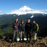
View of Mt Hood and Mirror Lake from the summit

After a quick lunch, we continued, traveling east on the rocky ridge of Tom, Dick and Harry. This portion of the trail was all new to me so I was pretty amazed with the views of the mountain, the rock walls and the ridge itself. While traversing the ridge, I noticed a small valley down bellow with several frozen lakelets that I didn’t know about. According to the map, a creek starts from there but the lakes are just tiny blue dots. We continued on the ridge until we got to the top of one of the Ski Bowl ski lifts. In a map nearby I learned that those lakes and the basin it’s known as the five lake basin which made wonder if there was a way to hike thru there on our way back. We continued for a short while on the back side of the ridge and at some point decided to veer off and start navigating towards the lakes. At some point we discussed turning back as we were not having any luck in finding the lakes and we were descending quite a bit. Just when we were about to do that, I noticed an opening in behind some trees and there it was, Slide Lake. This was probably one of the most beautiful scenes I’ve seen as the lake was not completely frozen but had a snow cover. That gave the lake a flat grey color that was just amazing.
Slide Lake

From there, we started circling the lake looking for an easier way up back to the ridge. Coincidentally, that travel route was roughly in the same direction to the second lake so we almost stumped on it. This time though, we were not able to get close to it so we continued our way up to the ridge. After a while we finally made it back to the top of the lift and, as we were hiking back started looking at the Five Lake Basin with the same idea I had earlier in the day. We studied the map a little and decided to go off trail again towards the lakes and the cut to the west to head back towards Mirror Lake. All that sounded really good in paper so we just started heading down. That’s where the hard part of the day started. First we had to go down on a very steep, snow covered, rocky slope that eventually got us to the lake basin. On that slope we managed to sink in almost every single posthole there was, so it was not easy going. Finally at the basin we walked thru these lakes admiring the beauty of the area.
One of the lakes in the Five Lake Basin

We then continued descending thinking we were going to find an easy path towards Mirror Lake, wishful thinking. At some point we found ourselves looking down on a very steep drop off so we had to turn back and retrace part of our steps moving farther west which in turn made us go to another abrupt edge with a big drop off. By then it was already getting a bit late and the sun was quickly moving down. To make it worse, there were some menacing grey clouds moving in the area as well. So our best bet was to just bushwhack down towards the highway thinking that our worst case scenario was a long walk on the road. So after figuring out a good direction, we opted for the one that offered better chances for us to grab to something, which meant going down slopes covered in Rhododendrons. I have to say that we got to love those trees. They are flexible yet very strong and don’t snap back at you that bad. Still, a machete would have been a good thing to have for a change. We finally made it to the lower forest and taller trees which made moving much easier and quicker. By then it was almost dark so we shoot a straight line towards the creek that runs alongside highway 26 and followed that back to the car. We finally got out of our adventure with enough light to get in the car and just minutes before the rain started. That’s what I call an awesome day!
You can check the pictures here
No comments:
Post a Comment