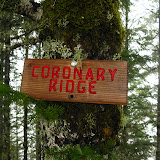
Also known as the Lester Creek Trail, this trail is actually a section of the Wilson River trail in the Tillamook Forest. What makes it appealing though is that this is the only section of the 30+ miles of the Wilson River trail that doesn’t run next to the river or highway 6 as it has to go around some private property. Since it was only three of us, we decided to start from the Jones Creek trail head rather than Diamond Mill. Not only it added a bit of distance to our hike but also, it was easier and faster to reach. The first part of the hike, going towards Diamond Mill was a nice walk thru dense, fern covered, coastal forest. Along the trail we could hear the North Fork of the Wilson River until we got close to it and spotted a small waterfall. We found a side trail to a view point right across the river with a clear view. There was a way to get closer but with the wet terrain and mud, it would have ended with us falling in the river. Around the corner from that point is the famous (or so they say) hanging bridge over the Wilson River. In season it’s easy to spot Salmon as they swim against the current. After the bridge, we started climbing thru more dense forests and very limited views due to the weather. We found a spot that probably has some impressive views of the Lester Creek Valley but, as you’ll notice in the pictures, we only saw clouds. As this spot was not good for a rest stop, we continued up on the muddy trail until we got to the next opening. From there we could barely see a huge rock formation which I believe is the Lester Pinnacles. My original intention was to just make it up to that point and then turn back, but since it was so anti-climatic, we decided to continue on for a while. In the map I had, there was a short trail connecting the Wilson River trail and the King’s Mountain Trail that went over King’s Junior Mountain starting from one of the ridges. We started looking for the trail as we went over the ridge and were not able to see it on the first pass. Noticing that we were already heading down on the other side and that we had missed the junction, we turned around and headed back. This time, we did notice a very faint path going steeply up the ridge. We took the turn and started heading up. This section was not long but it was definitely steep, so much that at the top we found a sign naming the trail the Coronary Ridge. Obviously we didn’t get the views although I bet they are fantastic which is why I will have to try this again. After a short lunch we turned around and hiked back the same way.
You can check the pictures
here

No comments:
Post a Comment