Flag Point via Lookout Mountain, Sep 20th

For reasons unknown to me yet, I have overlooked some trails on the east side of Mt Hood. Perhaps part of it is because is a longer drive. Reality is this is the second hike I find on this side of the mountain that ends up being particularly surprising. Flag Point is an active, and one of the tallest, lookout towers in Oregon. From its vantage point, it can monitor the Barger Creek Wilderness and beyond. Apparently there are several ways to get there (even by car). One of those routes starts from High Prairie going past Lookout Mountain which is the route we decided to do. Getting to the trail was not difficult at all other than driving for a while on a dirt road. From the trailhead, you already get a feeling that the hike will have splendid views as you start pretty high up. Contrary to most trails, that the reward is at the end or before you turn around to go back, this hike has rewards almost from the moment you step on the trail. When you start, there are to trail options, one that crosses the prairie and the other that circles around it near the cliff end overlooking valleys bellow. Views at this point don’t extend far due to tall trees, but it doesn’t take very long to reach Lookout Mountain. At that point views in all directions open up. Right in front of your face to the west is Mt Hood. Looking north, on a clear day like the one we had, will give you clear views of Helens, Adams, Rainier, Goat Rocks and beyond. A very cool thing about this view though is that being farther east makes Rainier and Adams look almost aligned. If that wasn’t enough, turning south opens the views to Jefferson, Three Fingered Jack, Sisters and beyond. The incredible thing about this destination though is that is very easy to get to and the hike is not long by any means. We did stay there for a bit sucking in all those vies before continuing on towards Flag Point. After Lookout Mountain, the trail descends quite a bit as it travels on a ridgeline. There are several knobs on the way with user trails to open spots with more amazing views. About half way to Flag Point, you pass a spur trail that goes to Oval Lake and Fifteen Mile camp, another access point. Between that point and the road that lead to Flag Point, you get more of those clearings with great views but these are all rock outcrops. Some of them with intricate shapes due to wind erosion. Beyond that the valleys of the Badger Creek Wilderness extend in front of you. It’s quite impressive. Towards the end, the trail joins an access road and a short walk uphill will get you to the lookout tower. We climbed to the top of the tower and met the guy manning it. I can’t remember his name but he took note of all our names to keep track of visitors and was kind enough to show us around and answers all our questions. It was interesting hearing that he spends 4 to 5 days in a row at the lookout tower just watching for fires. It’s a solitary life but certainly not a boring one. On the way back we made pretty much the same stops as we did on the way up just enjoy the views a second time. We also took the little detour to Oval Lake which didn’t meet our expectations. After a long, dry summer, the lake was very low and full of flies. Not very inviting. After I mapped this hike, I noted some other trails in the area that I’ve put on my list, so you can expect more explorations in the side of the mountain.


Interactive map

To see the full map, click Menu and select Full Screen. You can also click Terrain to change the map style

Wood Lake – Indian Heaven backpack, Sep 13th to 14th

Almost at the very last minute and eager to go out and spend a night, Val and I packed our gear and headed to Indian Heaven. This wilderness is a place that both Val and I have visited numerous times in the past but stopped because the window is a bit small if you want to avoid flooded trails and mosquitoes. It also holds a special place for me as it’s the first place I backpacked when I moved to Oregon and where I did a solo with Shia. While planning and getting the gear ready, I recalled how much fun Shia used to have every time we went there. It was hard for her to choose where to go first but she made certain that every lake, pond and even mud puddle was properly tested by jumping head first. I realized that I had to take her with me one more time and let her go.

Day 1: Thomas Lake to Wood Lake

We got to the trailhead in good time and hit the trail going towards Thomas Lake. The parking lot was pretty packed so we didn’t know what to expect in terms of people but we had an open plan. The only almost fixed idea was to follow the old Cascade Crest Trail that has been decommissioned for some years when the PCT was established. The first part of the hike was as I remembered it. Shortly after leaving the parking lot, you reach the Dee Lake and from there on is one lake after the other. The new thing I found is that some of the closer lakes now have designated campsites so I guess a lot of people don’t go far into the wilderness but prefer to stay closer. We didn’t make any major stops on our way in until we got to what looks like a junction near Rock Lake.
The Thomas Trail at that point makes a sharp turn right to head towards Blue Lake. Right across from the turn there’s a log and beyond what looks like a foot path left by people going to the bathroom. That was actually our sign to leave the main trail and go exploring. In all the times I’ve been to Indian Heaven, I had never explored this trail so all this was new to both Val and I. The trail gets a bit faint in the beginning but after that is real easy to follow as it travels north passing several open meadows. It clear why the trail was decommissioned as the area is very fragile. Some parts of the trail go thru pine forests and then open grassy areas. Being late in the season, we were welcomed with bright reds and yellows. That in contrast with the deep blue skies made for some very beautiful scenery. We passed several dried ponds and a couple of streams. Towards the north end of the trail, shortly before joining with the Elk Lake, we came to Acker Lake.
The trail passes on its East side by a huge pine with a very nice campsite and fire ring. We thought it would make for a nice place to spend the night but since it was still very early in the afternoon, we opted for a short lunch stop by the lake before continuing on. At that point we looked at the map and considering how much we had traveled we decided to try to get to Wood Lake to camp. Neither of us knew that lake so we didn’t know what to expect in terms of people and campsites. Continuing north, we got to a trail which I though was the PCT but son realized it was the Elk Lake trail. We could see Bear Lake thru the trees and discussed whether we wanted to go check out Elk Lake farther west. We opted to skip it as we saw some campers already on Bear Lake. Then we joined the PCT and continued North thru the forest passing just a couple of ponds and gaining some elevation. I remember doing this trail while backpacking solo with Shia to go around Bird Mountain and descend towards Cultus Creek on the other side. Back then, we got scared out of our pants when an elk came running and crossed the trail to disappear almost instantly on the other side. I remember only seeing the white butt at face level as it faded thru the trees. This time we didn’t see elk but the trail was pretty quiet and desolated. We stopped and evaluated for a minute the possibility of checking Placid Lake but then, realizing it was a long walk down and that Placid Lake has a trailhead close by we decided against it to avoid filled campsites. We pushed on until we found the junction with the Wood Lake trail and took the turn. The trail itself looked like a deconditioned trail or a trail that is rarely visited. Branches and overgrown grasses obscured part of the path as we lost elevation. At some point we got our first glimpse at the lake with its beautiful blue sheen.
We got excited and continued as it was looking very promising. Finally we got to the lake and found a foot path that went around. We took the west side just because and almost bushwhacked our way around looking for a campsite. We noticed then that we had a steady wind blowing thru so temperature seemed to be going down quick. Finally towards the northwest side, we found a shallow meadow with a big tree in the middle and a campsite. We dropped our bag and explored a bit just to be sure but we stayed there. While setting our tent up and filtering water we had what would be the first weird encounter of the weekend. Out of nowhere came to guys in full camo with bows and arrows. Silently they walked out of the forest, waved at us, made a turn west, continued and disappeared thru the forest. It left us with a bit of an uneasy feeling knowing we had a couple of hunters close by. As the sun went down and the wind kept blowing it got pretty cold quickly so we made dinner, ate and went for a quick walk to check the colors as the sun illuminated Mt Adams and Rainier red.


Day 2: Wood Lake to Thomas Lake

We woke to a sunny and equally spectacular day on Sunday. After doing our normal chores and packing we started our hike back by climbing back on the Wood Trail back to the PCT. At the junction we met the first couple as they were pushing north to go back home. We retraced our step on the PCT for a while and met more people heading out – all the people we missed the previous day I guess. Just before Deer Lake, we reached the form with the Cultus Creek trail that connects with the Cultus Trailhead and the Lemei Lake trail. That trail circles around Lemei Lake before joining the PCT again.
Since we had done that section the day before, we took the alternate route to enjoy the different scenery. We passed a couple of lakes and hiked next to big rock slides on our way to Junction Lake. After the lake, at the junction with the East Crater trail is when we had our second weird encounter. As we approached the junction, we saw an older guy with three teenagers. The older guy was resting a bit while the “kids” were playing. As we got closer, I noticed one of them was actually carving his name on the PCT sign. I got really pissed as the signs were pretty new and this – guy – was already defacing it. When we got close, I thought about saying something to the older guy but then I noticed the jean overall and the three packs, all with hunting rifles propped next to a tree. I thought it was illegal to hunt in wilderness areas. Maybe carrying a weapon is not, who knows, fact is, it was depressing to see that. We got on the PCT and for a while I couldn’t get the image of my mind. I recalled talking about with Val who felts roughly the same way as I did. Continuing on, the PCT gained a bit of elevation as it went around the East Crater. There’s no trail that goes there but I’ve read reports of people going in to explore – is on my list. On the way down from East Crater though we met another couple hunters dress in camo with bows and arrows. We were both very perplexed as we passed them by while they were putting on some deer pheromones or something to get in the woods. Disturbing. Finally the PCT took us to Blue Lake where we stopped for lunch.

I showed Val the place where I pitch the tent the first time I was there and how Shia would run around the lake and jump in to go get a stick. After lunch, we sat for a bit in front of the lake and I dispersed some of her ashes keeping the rest to disperse in some of the other lakes she jumped and swam in. It took me a bit to recover from the sad moment but then we continued our path on the Thomas Lake trail going back towards the trailhead. With the time we had, we were able to make several stops in several lakes along the way. We hiked quiet most of the way as I was remembering Shia. We made a final stop at Thomas Lake were Val dropped her pack and read for a bit while I got my feet wet. Finally we hiked the little last portion of the trail back to the car to finish another great adventure.


Interactive map

To see the full map, click Menu and select Full Screen. You can also click Terrain to change the map style

Cooper Spur, Sep 7th

It had been a long time since Val or I did this hike. I do remember that I had never done it with her so my best guess is that it’s been over three years. We picked it because we hadn’t done in a long time and also because it’s relatively short – although you gain significant elevation. We had plans that night so knowing the weather was going to be nice, we woke up early and head for the mountain. I remember the trail being very easy to follow and a separate path that followed a straight approach over the ridge. The part I wasn’t aware was a well-travelled foot path that climbs on an adjacent ridge. By mistake we took that path which gave us pretty interesting views of the Eliot Glacier and Langille Crags. We discovered pretty soon we were not on the trail but decided to continue on for a while as the ridge veered towards our destination. Towards the end of it, we noticed it would have been a hard climb over scree to continue on that direct path but right then we found a spur trail that crossed a small valley and ascended to the other side right above the Cooper Spur Shelter. Once on the trail, we continued climbing up steadily until we reached our destination. The ridge was clear of snow allowing people to continue much higher to the bottom of the glacier but being a bit short on time, we decided to turn around and head back down. This time though, we took the correct trail back to the parking lot.


Interactive map

To see the full map, click Menu and select Full Screen. You can also click Terrain to change the map style

Foggy Flats backpacking weekend, Labor Day Weekend

In my search for new places to explore I found a series of trails that travel on the north side of Mt Adams. These trails are not visited as much part because there’s not a lot of information and part because some of them enter the Yakama Indian Reservation which requires special permits that are difficult to obtain. Still, I had my sights on Foggy Flats and Avalanche Meadows. While thinking about it, I noticed that Zach had posted a trip with the group to the north side of Mt Adams which was this exact same trail so I decided to join. The plan was to leisurely head out on Saturday and hike to Foggy Flats to camp, explore on Sunday and then head back out on Monday.

Day 1: Muddy Meadows to Foggy Flats

On our drive to the trailhead, we noticed that weather was looking kind of rainy and on the colder side. We got to the trailhead and just when we started hiking, we felt the first drops of rain. It was just a mist so we decided to just keep on going. From pictures I’ve seen in the past, I knew Mt Adams was right in front of us, but the low clouds were completely obscuring the view. The only thing in front of us was a big meadow and a dark sky. After passing Muddy Meadows, we started our slow climb towards the PCT. The trail in this area is very dense and covered so there are practically now views. We did get a bit lucky with Huckleberries though so we made numerous stops to grab some and eat.
We made a short stop at the PCT junction, part to grab a bite and another because we were right on the dates a lot of PCTers pass by so it’s always nice to see them and give them some trail magic. That day, we saw nobody. From there, we continued our climb towards the Highline trail. The skies looked very menacing and every so often, we would get some rain that would quickly dissipate. Then we got to the junction with the Highline trail and it started pouring. This time it was for real so we had to stop and quickly get our rai gear out. It took no time for our feet to get wet and I was already almost lamenting a bad call on my part regarding gear. I was wearing the kilt which can be the best or the worst depending on conditions. We pushed on with the rain hammering on us up until we got to Foggy Flats. The rain had stopped but everything was soaked, including a potential campsite with great views of the mountain. We dropped our packs and started wondering around looking for sites and finally, after a while, we spread out and set up our tents. I decided to set up by the open meadow with direct view of the mountain. One of the plans I had was to take pictures overnight so I needed a good spot. After that we did all of our camp chores and had dinner. The wind picked up later that evening making the temperature drop abruptly. It got really cold so we all hit the bed relatively early.

Day 2: Devils Gardens exploration

On Sunday we woke up to a bright, sunny and very windy day. Clouds were moving incredibly fast above us so it was difficult to know what the weather was going to be like for the rest of the day. After breakfast, we grabbed our day gear and continued on the Highline Trail. Little did we know that only a couple of minutes later we would find plenty of dry and much better campsites than the ones we picked. I guess that’s what happens when you don’t know. The other incredible thing was that we left the forest behind and entered open semi-arid meadows. I was completely different scenery. The trail crossed several affluent of the Muddy Fork which at times can be tricky.
We got lucky that water was not too high and crossing was a breeze. After the last crossing we got the first views of Red Butte towards the East and the mountain in front of us. It was an image out of this world. It really looked like we were on another planet. WE followed the trail as it meandered thru the lava fields skirting the mountain. At a certain point, when Red Butte was almost directly south of us, we saw a small group of people on the ridge signaling to us to go over. That was right before reaching the Yakama Reservation boundary. Checking the map, we noticed that we were just south of the Devils Gardens, so we left the trail behind and started going off-trail. Once we reached the ridge, we saw the expansive area in front of us and understood why it’s called Devils Gardens. The whole area is completely desolated, there’s practically no vegetation and the only thing you can see, besides Mt Adams, is volcanic rocks that seem like the exploded from underneath and were frozen in the act.
As we hiked closer, we passed several of these formations and you could also see them moving as they were taking shape, not in a slow way though. The literally looked like someone had stopped time as they were moving. WE continued towards the mountain aiming for a ridge right in front of Lyman Glacier. Once there, we went up a bit to catch some better views of the mountain but by then the wind was howling. We saw very dark clouds coming around the mountain. As minutes went by, the mountain disappeared and reappeared in front of us several times. We decided it was time to stat heading back. We followed the ridge going down trying to cover ourselves from the wind until we reached the Highline Trail again. From there, we retraced our steps back to camp keeping our fingers crossed that it would not rain on us. It didn’t. And despite very dark and heavy clouds moving quickly above us, we got not even a drop of water that night. That evening, while I ate, I did a time lapse video of the fast moving clouds. I also tried taking pictures of stars for the first time.

   
Day 3: Foggy Flats to Muddy Meadows 
   
Monday was even a better day, dry, crisp blue sky and less wind than the previous days. We took our time to have breakfast, pack out gear and hike back down retracing the step we had taken on Saturday. The trail was the same with limited views but now we were able to see Mt Adams from the meadow near the trailhead and on the drive back. It was a glorious short day as we were already on our way home Interactive map To see the full map, click Menu and select Full Screen. You can also click Terrain to change the map style

Gales Creek, Aug 24th

About five or six years ago, while trying to find new areas to discover and explore, I found information about Gales Creek. The description talked about a beautiful fern covered forest with multiple streams flowing towards Gales Creek. I made plans to go check it out only to find that they trail had been closed due to a washout. While I waited for the trail to reopen, I explored other trails in the area but then I learned that the trail closure was going to take longer. Not only they needed to reroute a big portion of the trail but an accident involving one of the crew workers delayed the whole thing. About a year ago, without a lot of noise, the trail reopened and I found when a friend went there. Finally it was time for me to check it out again so I planned a hike with the group to do it. I can say I was pleasantly surprised with the hike even though there was something missing. Certainly the area has enough greenery to feed your needs. The tall skinny trees and the ferns make the forest almost magical. The missing part was all the streams. Although I lost count of the number of streams that appear to cross the trail, none of them had any water. With the dry summer we had, all of them were dry. Not only that, Gales Creek itself was running lower than usual, something that was easy to note just by looking at the creek shore. I may need to revisit this trail when the water comes back


Interactive map

To see the full map, click Menu and select Full Screen. You can also click Terrain to change the map style


Twin Lakes - Sawtooth Wilderness backpacking loop, Aug 11th and 12th

Continuing our honeymoon, Val and I spent a couple of fabulous days in Boise after backpacking the Teton Crest Trail. Our original plan was to hit the trail again on Sunday for a 5 or 6 day loop in the Sawtooth Wilderness, but after dealing with rain for 5 days, we decided to take an extra day and shorten the trip. That changed our trailhead as well so Sunday we drove around the wilderness to Stanley, ID were we stayed the night. That night we checked weather forecast and packed our gear for an early departure the following morning. The forecast was not very promising but we still opted for following the plan and hitting the trail.

Day 1: Pettit Lake to Twin Lakes

After a quick breakfast in Stanley, we drove the ten or so miles to the trailhead and got on the trail in no time. The morning was spectacular and very promising with clear blue skies and warm temperatures. At first the trail took us on the north side of Pettit Lake all the way to the end were, after passing a small meadow, left the valley behind and started climbing towards Alice Lake. It didn’t take long for us to leave the lake behind and start traversing a canyon with huge granite walls on both sides. It almost seemed like every other step, the scenery was different and we had traveled a long distance when in reality it was just a different perspective. The trail follows a creek most of the way that in most places you can only hear. After several turns and crossing a very shallow creek we finally got to the first lakelet below Alice Lake. In front of us was a cirque of tall peaks and incredible scenery.
For a while we walked around the north side of Alice Lake enjoying the views of towering El Capitan (not to be confused with the California Version) on the other side. WE left this scenery only for a moment to climb just a bit more and then descend towards our destination. We arrived at Twin Lakes right to the stretch of land that separates them. Just by instinct and because that was the way we would follow the next day, we turned right and continued north on the shore of upper Twin Lake until we found a campsite. We dropped our backpacks and went checking for other sites but didn’t find any. It was still pretty early in the afternoon so we set up the tent and relaxed a bit. I got in the water for a while and stayed there for as long as my legs were able to comfortably take the cold water. After that, I went exploring a bit, first back towards lower Twin Lake. I walked pass the junction we had arrive from and decided to explore a bit around the stretch that separates the lakes. In that area I found the best campsite. It had big fire pit and views to both lakes. We had already set up so moving was not an easy option. On my way back, I passed or campsite and continued on the trail we would take the following day towards the north end of the lake. The trail starts climbing quickly on that side so that extra elevation gave a really good angle and view of the lake. I took a couple of pictures but made a mental note to go later in the afternoon to get some nice light and take more pictures. We had a nice dinner that night and after putting everything away and hanging the food, I went back to the north end to sit and take some pictures. By then, he sky was already graying out a bit. There was no rain yet but it wasn’t looking very promising.


Day 2: Bail out

The next morning we woke up to a very grey and almost cold morning. We guessed we got some drops of rain thru the night but nothing like we had in the Tetons. Still, the clouds and sky were corroborating what the forecast said. The original plan for the day was to go over the pass towards Toxaway Lake and then continue north towards Kramer Lakes or west towards Edna Lake. Either of these routes included going over passes or hiking on ridgelines. With bad weather, that didn’t seem like a very good idea. So we started our hike going north passing by the spot I had gotten to take pictures the previous night. From there, the trail just traversed the hill on a couple of very long switchbacks until we got to the saddle.
At that point we got our last view back at Twin Lakes which, at that elevation looked just fantastic. From there we stared descending quickly towards Toxaway Lake. On the way we passed a couple of very shallow lakelets filled with turquoise water. Above us, the clouds still looked very menacing. This chain of lakelets was connected by a creek that moved water from the ridge down to the lake. So the trail continued traversing the hills close to it. The final approach to Toxaway was a series of switchbacks on the right side of a huge rock filed were you could see numerous waterfalls. Going around Toxaway was not very interesting as view of the lake were limited. That was until we got to the north side. The lake itself is beautiful especially because of a small island in the middle. About half way on the north side, we found the trail junction going up to the saddle around Sand Mountain. By then the sky was not showing signs of improving so we called it and decided to continue down towards the car rather than risk it and go over the pass. From there to the next lake, Farley Lake, the trail took us by several small lakes and ponds.
I recall one in particular that might have been no more that 10 or 12 feet in diameter but very deep. It almost looked like a small crater filled with water or a sink hole. While passing by Farley Lake, the sky cleared up a bit and it almost seemed that it was going to hold but that didn’t last long. By then we were already descending towards the forest as the clouds were quickly moving in. We kept on hiking trying to maintain a good pace as we knew the rain was coming. We could even smell it in the air. The wind picked up and then the first clear sign, thunder. At first it was far away but as we continued, they seemed to be getting closer and closer. We got our rain gear out and put it on when it started raining, lightly at first but getting worse by the minute. When we passed the lowest point of the connector trail that would take us back to the trailhead, the sky was incredibly dark and the sound of thunder was almost nonstop. We pushed on. Right after passing the last ridge line, where we knew it was all downhill from there, we got the think of it. At first it was pouring rain with wind, lighting and thunder, but then it started hailing. Finally we saw the shore and we knew we would be out quickly; we just needed to hike around the north side of the lake to the parking lot. As we did, I looked back to a complete different image of the lake than the image we saw the day before. From our point of view, we couldn’t see the other shore much less the towering peaks on the other side. Not only that but we also so waves on the lake.
It almost looked like we were on an ocean coast. We finally made it to the car just when the rain stopped so we had a chance to put our gear away, dry up, change and start driving. The dry spell didn’t last long and we got more of the storm while on the road. As we drove away from the Sawtooth we couldn’t believe the clouds around us. We knew then it had been a good call to bail. We got a nice glimpse at this magnificent area that we’ll certainly visit again sometime, hopefully with better weather.


Interactive map

To see the full map, click Menu and select Full Screen. You can also click Terrain to change the map style

Teton Crest Trail – Grand Teton backpack, Aug 4th to Aug 8th

This is a trip that Val has had in her to do list for a while. I didn’t know much about it but after reading a bit it was certainly going on my list as well. Then we both decided it was a great trip to do for our honeymoon. Planning for it was both easy and complicated. First was getting permits. At first we laid out a plan for 4 days and made a plan to login and get the permits as soon as they became available. We learned in a few minutes that some people either have very fast fingers or some spots are taken before they permits are offered to the public. In the end we ended up getting permits for a 5 day 4 nights and not even one of our original camping spot choices. The second part was a bit more complicated as we needed to hire a service to either shuttle us from one end of the park to the other or move our car. And then was the part of planning for food and gear and the extra weight in the form of a bear canister and bear spray. With all that, our expectations for the trip and seeing wildlife were pretty high. When the day came, we took a two day leisurely drive that took us thru Idaho all the way to Jackson in Wyoming. We stopped at the ranger station were we got permits and bear canister and then went back to pack it all up in a little cabin we stayed. That night we got the first ominous sign of things to come – rain.

Day 1 - Jackson Hole Tramway Summit to South Fork Granite Zone

That little drizzle we had Sunday night was rain on Monday. With permits in hand, we drove to our starting point in Teton Village were we left the car and spare set of keys cleverly hidden behind the wheel. We went back and forth a couple of times thinking if it was a good idea to go or wait and after a while we grabbed our gear, jump in the tram and started going up. The tram saved us from having to climb over 4000’ on our first day which is what most people do. We landed at the tram summit which slightly above 10000’. The whole thing was completely covered in a cloud so we couldn’t see anything. At the top there’s a small coffee shop were they serve waffles. We followed our noses to
there and got our rain gear out. While doing that, both Val and I had a close encounter with the lack of oxygen. Tying your shoes and then standing straight made us realize that we needed to take things slowly. Then, a bit reluctantly we decided to step out of the comfort of the warm building and start our journey. The first part was kind of tricky as we couldn’t see far so we followed an old road as much as we could. Luckily the trail descends from the summit so we got under the clouds pretty quickly and found our first intersection where we took the Rendezvous trail. We also found the Bear warning sign…
From that point on, trail descended towards the South Fork Granite Creek valley where the views expanded a bit allowing us to see some pretty amazing rock walls to the south. We noticed that wildflowers were not only abundant but also huge. We learned later that it was very unusual for this time of year to have so many flowers. As we hiked, the skies went from fully covered, to partially covered to grey again.
After taking the cut-off trail we finally reach the trail we would travel on for the next couple of days, the Teton Crest Trail. At that point we were already in the camping zone we were staying that first night but following the recommendation of the park ranger, we continued until we reached the end of the zone. The ranger told us we would find good spots around there and that the scenery was spectacular. He was not lying. The last part of the zone climbs gently on a wildflower meadow that ends at a saddle and drops on the other side. Towards the west, the valley is protected but huge
vertical walls. To the east and south, the meadow rolls down towards the middle fork of the Granite Creek.
We found a nice spot protected by the trees just off the trail and very secluded. After setting up camp we made a short trip to get water and then dinner sitting on the tarp surrounded by flowers. The sky above was grey by then and when we were done and walking back to the tent, the rain was starting.

Day 2 - South Fork Granite Zone to Alaska Basin

In our original plan, we wanted to camp one night on the Death Canyon Shelf, First because a friend of us had strongly recommended it and two because it was probably one of the most scenic places along the TCT. Unfortunately, we were not able to get permits for that zone. The ranger also mentioned that there was no water there… more on that later. So the plan for the day was to hike thru the Shelf and continue on the other side to Alaska Basin where we would spend the second night.
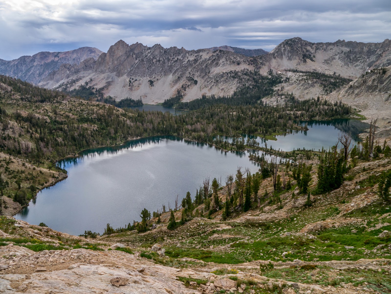
The day started with a small visitor that really wanted to know what that tent business was all about. As we were packing our gear, this little fellow tried to get in our tent a couple of times. He was clearly not scared by our presence. Once packed and ready we started hiking down towards the North Folk Granite Creek on a very gray day. We had done the first part of the trail the day before when we went to get water. With the overnight rain, the trail was a lot muddier than before. After getting down to the valley, we crossed the creek that was pretty dry and started climbing again thru more wildflowers until we reached Marion Lake. The lake was spectacular and empty despite having a group size campsite.
Then came a long walk thru beautiful flowers, dark grey skies and tons of mud until we reached the shelf. Luckily the shelf was more or less flat so we only needed to concentrate on not sliding off the trail with the mud. Weather was very unstable and as we continued we got rained on several times. At times the clouds would raise just enough to let us know that there were views we were missing. Along the way we passed countless creeks flowing of the snowpack across the shelf and down – plenty of water everywhere. A little past noon, we wanted to stop for lunch but with the rain, mud and weather, we opted for a quick standing lunch. Not the ideal when you have great views but then, we didn’t want to get to cold. We left the shelf and then the park on a section of the TCT that crosses out to the Targhee National Forest. From that point, the impressive, and imaginary for us, views of the Tetons are left behind and a view towards the west opens up. Right after passing Mount Meek Pass the scenery switched to a more arid alpine scenery. Behind, Mount Meek extends on a ridge a wall towards the northwest that seems to have no end.
In that area we found our first snow as we traveled over Sheep Steps before descending down to Alaska Basin. Rain continued to come and go as we hiked down long switchbacks to a valley and then climbed again to a subalpine meadow dotted with small lake. By then we were ready to drop our gear so we took the first campsite we found a few feet of the trail but behind some trees. Later that day, once we had picked up water and were ready to have dinner, rain started again. With no signs of clearing up, we set up a tarp between some rocks and a tree and managed to crouch under it to cook and eat. Once we were done, we waited for a while so we could grab everything and go back to the tent without getting completely wet. At some point we started getting cold so there was no other way than a quick run, changing into dry clothes and jumping in our sleeping bags. For the second night in a row, we were inside early in the evening listening to the rain. I woke up several times during the night just to learn that rain wasn’t going away.

Day 3 – Alaska Basin to South Fork Cascade Zone

Due to the changes in our original plan, day three was a shorter day but included going over the second highest pass in the route. We started again on very grey day with a light drizzle that stopped at some point. After crossing the south fork of the Teton Creek, we started gaining elevation slowly with some views towards the west. We passed thru Sunset Lake which, with clear skies must be spectacular; with our weather it looked really nice. Strangely enough the trail was much drier on this side of the mountain so that was a relief. As we gained elevation, the surrounding terrain got flatter to a point where it looked like we were in a gigantic football filed. In the distance we could see the ridge edge close to Hurricane Pass. Up there we had a close encounter with the locals. As we were hiking we saw tons of marmots that couldn’t care less of us being there. Short of the top, Val stopped to get a bite to eat and turned to face me.
We noticed a Marmot to my left that was interested in us so as I walked towards Val; the Marmot started circling her from behind until it got on the trail. Once there, I asked Val to stay still as I took pictures of the marmot as it came towards us almost asking for food. I’m guessing it was not more than two feet away when it turned around and went the other way without rushing. We saw several more before we got to the actual pass were two more were siting enjoying the view. As we passed by, one got close to the other for a kiss. I guess part of was for the view we didn’t have yet. A few yards after that, we got to the edge were the trails drops and the views open up. To our right we could see the Schoolroom Glacier and the lake below it.
Ahead of us we had deep valleys and incredible peaks. Even though the clouds were covering most of the scenery you could easily get the idea that there was a valley deep below us and an insanely high peak behind. Probably one of those rock walls climbing and disappearing in the clouds was Grand Teton. As we hiked down towards the valley and lost a lot of elevation, we noticed that there were more chances of getting in the rain zone. That was proven beyond doubt when all of a sudden we got a hailstorm. We were almost trapped on the trail with nowhere to go for cover so we stopped, got the tarp out to cover ourselves and waited. After that the 20 minutes of heavy wind and hail we decided to look for a campsite rather than continue farther to the end of the camping zone. We were lucky for a while as it cleared enough to get some sun and dry some stuff as we set up camp. Sun didn’t last long. The sky turned grey again and it looked like it was going to rain again. We took our gear down to the trail and, as we were about to start, the rain started again. We were under a tree which made setting up the tarp a bit easier. The wind didn’t help much though. We finished dinner, put everything away but still had to wait for a good hour before we could make the run to the tent. We were cold, tired and wet.

Day 4 - South Fork Cascade Zone to Upper Paintbrush Zone

We woke up with the idea of bailing as we were done with the rain but almost changed our minds as we woke up to clear skies and sun. For a short while we were able to see mountains around us and the valley we had descended on the night before. With that, instead of going down on the trail to our dinner spot, we climbed on a big rock to have breakfast with a view. It was magnificent for a while but then fog and clouds moved in quickly. The entire valley disappeared in front of us. And then it disappeared again giving us some nice treats.
As the fog was clearing out we could see sun rays filtering thru the trees illuminating the valley below us. We were unsure what the weather was trying to do so we packed and got back on the trail. We descended even more until we got to the Fork where both the South and North fork of Cascade Creek Join. We decided to continue on rather than bailing so we turned left and started climbing towards Lake Solitude. The first part of the climb was thru dense forest but then we found ourselves hiking on the side of a slotted canyon. We couldn’t guess were our next pass was but we knew we had a lot to climb before getting to our next camping spot. As we traversed the hills we passed an area that seen a considerable avalanche. We hiked thru packed snow and a lot of broken trees that looked to resent. We saw several hikers on the way but the big group was already at the lake when we got there. Clearly is a big destination for day hikers. The lake itself is beautiful and the surrounding area even more as you are in the center of a big circle. While resting and getting a bite to eat, we saw the trail ahead of us as it cut a straight line on the hill going up. It looked ominous from the lake. With that view, and the fact we actually had some sun, I changed before hitting the trail again. Then we started climbing. This was Val’s favorite part of the entire trip, the climb to Paintbrush Divide, the highest pass in the route.
The trail seemed endless as it went up and up and up climbing a bit over a thousand feet before it made the first turn. Two turns after that brought us to the top at about 10700’. Other hikers have told us that it could be tricky getting down on the other side of this pass. In their description, they said something like looking like a big football field, going left and descending from there. The trail was actually pretty clear and easy to follow before the pass; figuring that part didn’t add any challenges. Before getting to the very ridge, we had to stop to put on our jackets as wind was howling. Once we reached the actual pass, we were welcomed with an incredible view of the Upper Paintbrush valley.
A completely different view than the valleys we had seen before. This one looked more alpine and bare compared to the other ones. It was spectacular. We started our descend on the other side first going over loose rocks and then traversing snow banks. It was slow going for a while. We passed several potential campsites but decided to push on to shorten the distance for the last day. We knew we had a long day ahead. That idea made us make a mistake (unknowingly though). We passed a nice campsite that we ignored which ended up being the last campsite in the area. Once we reached the boundary we had no option but to climb back up to it. Up there we set up camp, and looking at the clouds, decided to set the tarp before making dinner. We were kind of expecting rain. As soon as we turned the stove on to boil water the wind started pushing us really hard. Then lighting and thunder started. Rain hadn’t started yet but we picked everything and run down to the valley and crouched next to a couple of big boulders. After setting our cooking gear in a small rock ledge, we placed the tarp over us and held it there while the storm passed. For about an hour or so, we heard the rain and thunder and saw the occasional lighting. It was a bit scary. Finally I decided to tie down the tarp around the rock so at least we could eat. So we cooked dinner and ate under the tarp while fending of a Pica that was very interested in what we were doing or our food. Finally the thunder stopped so we picked our stuff and went to bed. We were both done.

Day 5 - Upper Paintbrush Zone to Jenny Lake trailhead

Last day we woke up again to a clear day with the sun illuminating the paintbrush canyon. It was quite spectacular.
By then we were tired of eating far from our tent so we brought everything to the campsite and made breakfast there. We left the campsite shortly after and started our long descend to the String Lake trail. On that trail we went from alpine to subalpine to forested scenery as we left the tall peaks behind and hiked towards the open plain. It was incredible to see big jagged peaks behind us and a lot of flat land in front. It was like being in the dividing line between two different worlds. Finally we got down to the Valley trail which would take us around the south end of String Lake and the west shore of Jenny Lake. For some reason I had thought that Jenny Lake was not that big. It took a while to go around that lake that looked almost like a small sea from the trail.
Incredibly enough, we didn’t get a drop of rain that day, in fact I pulled my umbrella a couple of times for shade. Even though we had much better weather than the previous days, the hike itself was not as enjoyable. Part of it was because it was somewhat arid and the other because is closer to the trailhead so you have to dodge day hikers as you go. We finally made it to the trailhead without seeing a moose or a bear. Later that day, when we were back on the road towards Twin Falls in Idaho, we got the evening part of the storm as it was rolling slowly towards the Tetons. We saw really heavy clouds, multiple lightning bolts and tons of rain. I guess there was no rest going towards the Tetons.

You can check the pictures here


Interactive map

To see the full map, click Menu and select Full Screen. You can also click Terrain to change the map style

Table Mountain, Jul 27th

When Val and I don’t have a hike planned for the weekend we tend to just pick one of the classic ones that will give us some good exercise and a fair amount of rewards. With weather being almost on the crappy side, that’s pretty much what we did. We packed our day gear and headed out to the Gorge to hike Table Mountain once again. We did get descent views from the top which included MT Hood, Mt Adams and Mt St Helens. We also got our first glimpse at fall colors… yes, fall colors in July. Weird.


Interactive map

To see the full map, click Menu and select Full Screen. You can also click Terrain to change the map style

Marble Mountain Wilderness, Jul 3rd to Jul 6th

Looking for places to backpack during holyday weekends can be a bit of a challenge if you want to find a somewhat secluded area. It does get a bit more challenging if you start considering the weather in early July. Here in Oregon it can be a complete gamble so you could end up having spectacular days or pouring rain. The forecast for the weekend was not looking very promising so I started looking south, like in Central Oregon south. Same thing, farther south it was still the same so in the end, I started looking into Northern California. While doing that, I found a bit of information about the Marble Mountain Wilderness, a small area within the Klamath National Forest. From the description and a couple of pictures, it looked promising. Within the wilderness, there’s a very popular area, the Sky High Lakes which tends to be crowded even on non-holiday weekends. With maps and guides, I created a loop that touched on the highlights while still trying to avoid the crowds. And so we took off Friday night on long drive to Lover’s Camp where we would meet the rest of the group and start our loop

Day 1 – Lover’s Camp to Rainy Lake

Lately Val and I have gotten into the habit of driving the night before to the trailhead and sleeping in the car. That way, we can get a fresh and early start. It seems some other people got the same idea as we got to the trailhead at around midnight and just when we were about to fall asleep, two other parties got there.
Clouds over the ridge
The next morning we met with the rest of the group and soon were on the trail. For the first 4 miles, the trail travels somewhat close to Canyon Creek. You don’t really see the creek but you can hear it below you. There are several spots where smaller creeks cross the trail and continue down. As you climb, there are a handful of openings that will give you views of the Canyon Valley and some unnamed peaks on the other side.
Just when you start needing a break, you get to Marble Valley and the Forest Service Station. The spot is easy to recognize, not only because there’s a cabin in the middle of the forest but also because the views in front of you open up to Marble Mountain. This spot is also where the PCT crosses.
Forest Service Station
Originally I thought that by this point we would be close to the tree line and that most of our trip was going to be alpine. The wilderness is actually a bit lower in elevation than what I thought. Most of it is subalpine. We took a short break at the cabin and then continue on our intended route following the PCT north just until the next junction. From that junction we veered off to the west and started climbing towards Marble Gap, the small saddle in the middle of Marble Mountain. In that area vegetation is not too big so views extend south to the Canyon creek valley and to the north to Black Marble Mountain. As you approach the gap you can only imagine the views you’ll get but once there, you realize you were far from it. From the gap, the views extend to the west looking straight to Elk Peak, but the most amazing thing is to see what is known as the Marble Rim. The ridge is a semi-circle with sheer drops to a deep valley over 1000ft below.
South view of Marble Rim
From that point, the trail descends on the other side following the ridge and then turning and descending to the lowest point very abruptly. Differently to the trail on the other side, we found this trail to be brushier and less maintained. It seemed not too many people had gone this route in a while. Once we got to the Rainy Valley Creek junction, we turned south to follow the trail until we reached the last junction and short trail to Rainy Lake, our destination for the first night. We expected to find an open meadow with the lake so you could walk around it and set camp anywhere. What we found instead was a large site right before the lake and a foot path to a very muddy opening. The rest of the lake was forested and faint trail indicated that maybe you could go half way around but not too far.

Day 2 – Rainy Lake to Cold Springs

The plan for the day was a bit easier than the previous day. Only the first part was a steep climb back to the west end of the Marble Rim and then continue mostly o the ridge until reaching the PCT at Four Corners to then descend towards our destination. But son after we started, it seemed we were on an abandoned trail. If the previous day had been brushy the uphill from Rainy Lake was just crazy. In some section it was even difficult to see the trail in front of your feet. Luckily, after huffing and puffing and burning all of our breakfast calories, we reached the junction with the rim trail. From that point on, the trail was again well maintained and easy to follow. As we started traveling on the ridge, we passed by two saddles that opened the view to the rest of the rim that gave us a hint of what we would see later. But before that, we went back into the forest and traversed for a while on the side on the south most peak of the rim. There was not much to see for a while until the trail circles and comes on the other side where it opens to the east looking towards the Big Elk Fork. From that point, you see a small hill to the left and nothing more. As you walk and get closer to the next saddle you can’t avoid to salivate on the views you’re about to get and the saddle does not disappoint.
Marble rim from the saddle
There’s a small section of the trail that you literally stand a foot or two away from a sheer drop that must be well over 100ft. If that’s not enough, to the side you get the best view of the west side of Marble Mountain. We stopped there for a while to take pictures and pose in front of those views for a while. Then, after cleaning our drool, we continued crossing Marble Mountain again to the east side where we reached Four Corners, a trail junction with the PCT. We took the PCT south as it traveled on the ridge with ample views of Canyon Creek first and then the Sky High Lakes Basin. From the ridge you can’t see all the lakes, only
Frying Pan Lake
Frying Pan is full visible, but from there we could see and hear people below. It was indeed a busy weekend. Finally we found the junction to Shadow Lake. A short portion of the trail seemed that it was going nowhere even though you seem to get closer to a large black/green rock. Once you go around the last turn, the lake appears below with its intense blue color. As you get closer, the views get better and once you get there, you realize the lake sits in a shelf just above the Sky High Lakes.
Shadow Lake
From the side it almost looks like an infinity pool where the edge of the water just merges with the sky. From the information I had I thought we would find places to camp for the night but we found two things. The first is that there’s absolutely no shade in Shadow Lake. The other is that there are only three or four campsites so not enough space for all of us. Being early afternoon it didn’t make a lot sense for us to stay there. We did get in the water and ate lunch but staying any longer would have meant being fried alive. Being that he case, we had to think about an alternative and I thought about just continuing on the intended route to see what we would find. In a sense it was a pity we didn’t get to stay there as I think the views of the valley and Marble Mountain early in the morning must be spectacular. So after a while, we packed and continued on first climbing out of the shelf to a connector trail that would take us back to the PCT. Shortly after that, we found the junction to the Red Rock Valley, our intended route out. Right across from the junction, was another less used trail signed to Cold Springs. The map shows two tiny streams that don’t go anywhere but is market as campsite. We decided that it was worth checking it out so we took that detour and descended to a small meadow packed with wildflowers, and just like that, in the middle of the meadow, a small hole with water running out of it. The first hole looked a bit dirty but still usable. We noticed the trail continuing to a wooded area where we found not only a huge campsite with enough space for about 10 tents but also another hole and small stream with the cleanest, coolest and freshest water we had seen so far. Needless to say, we dropped our packs and stayed there.

Day 3 – Cold Springs to Lover’s Camp

Last day was the day out and we had a short hike so after eating our last breakfast we departed from our not so secret hideout. Once we got to the junction, we took the Red Rock Valley trail down. We passed a small meadow with trees and a small pond that I had seen in the map and thought it would be a potential stop if we hadn’t found Cold Springs. After going around this lakelet, we came to the biggest meadow I’ve seen.
Big Meadows on Red Rock Valley
It was big enough for you to get lost within the bushes and grasses. The first to disappear in it was Max, the four leg companion that came with us. In the meadow, the only thing you could see was some bushes moving and a black tail wagging. We thought it was only that section but soon realized the entire trail would pass from one meadow to another as we traveled fairly close to the creek. The other side of the creek was adorned with huge rock walls that had a reddish hue. I think in the afternoon, when the sun is in the other side these walls turn bright red offering a real spectacle. Finally we got some cows, one stream crossing and the junction with the Valley trail that took us back to the trailhead with plenty of time for that long drive back home.

Link to album

You can check the pictures here

Map

Interactive map

To see the full map, click Menu and select Full Screen. You can also click Terrain to change the map style

Silver Star grand loop, Jun 22nd

Ok, this is not the official name for this almost loop hike but since this is the second time around it, I guess I get to name it right? Silver Star is still one of my favorite spots for a day hike. There are multiple approaches from easy to hard and a couple that can be combined into a larger loop. This route combines the Starway Trail with the Bluff Mountain Trail completing an almost loop with a car shuttle. The first time I did this loop, several years ago, we got some snow that forced us to add a bit of distance to get to the car and some route finding. This time we were lucky to have perfect weather and conditions for a fantastic hike. Getting to the entry point for the Starway trail is not as hard as getting to Ed’s trail but still requires a high clearance car and being ok with one or two scratches on the paint. Once you’re there, the adventure starts by crossing Cooper Creek over a bridge and starting to climb. Most of the elevation gain happens very quickly as you gain about 2500’ in 2.5 miles. At this point, when you’re also ready to pass out, you reach a summit that can be a bit deceiving. The first time I did the Starway trail, this is a far as I got. It’s still worth the effort nonetheless as the views of surrounding peaks is spectacular. It truly makes you think you are at the Silver Star summit but that’s not the case. Around you there are multiple canyons and the highest peak, across from the canyon looking southwest is Silver Star. Coming to that realization makes you ask yourself what you are doing. Well, that’s part of the adventure. From there the trail is faint in places but the overall direction is simple to follow. As you travel south, the trail descends quickly to a saddle in the forest and then starts gaining elevation again. As long as you keep going in that general direction, you’ll eventually hit the Bluff Mountain Trail. Along this section, the views are dominated by the Star Creek Canyon and some waterfalls you can clearly see. One in particular falls into a slot canyon sideways. I’ve yet to find a route to it but that’s a future project. As you continue, if you’re lucky, or have good navigation skills, you’ll get to the clearly marked junction with the Bluff Mountain trail. Another sign that will tell you you’re there is the drop off in front of you and Mt Hood in the distance; this is just a teaser though, views still get better. From that point on it gets easier. Just follow the trail until it joins with Ed’s trail and get to the summit. You’ll notice that I don’t have a lot of pictures from the actual summit. The reason is we got welcomed by a horde of very hungry mosquitoes that quickly made certain to get a taste of us. I don’t think we stayed there over 3 or 4 minutes. We hiked back down to the saddle where a little breeze kept the hungry bastards at bay enough for us to have lunch. After that we retraced our steps to the Starway – Bluff Mountain junction but instead of turning left on the way we came, we continued straight. The trail is pretty easy to fallow and has some gentle ups and downs as it navigates the ridge. Passing on front of Little Baldy is always interesting as you hike on a trail in the middle of a rock pile. I always wonder what makes the mountain and the rock pile stay in place. Then the trail turns north and passes on the South side of Bluff Mountain. A faint trail seems to indicate you can get to the top of Bluff but I’ve never done that. Scenery changes a bit but you still continue following a ridgeline while descending. After going around two or three smaller peak, you finally get to the Bluff Mountain trailhead. It’s at higher elevation so you don’t descend as much as you climbed which is a welcomed note to your knees before the drive home.


Interactive map

To see the full map, click Menu and select Full Screen. You can also click Terrain to change the map style

Dry Ridge to Grouse Point, May 31st

I guess I could call this hike the “Finally getting to Grouse Point” hike. A couple of years ago I lead this hike with the group and once we got to the end of the Dry Ridge trail we found snow on the ground. My navigation skills back then were not as good and my shoe pick for the day wasn’t the right one either. To make the long story short, I had to change socks and head back down with wet feet. This time we got a much nicer day and with the lack of snow, I was in serious doubt we would find any snow on the ridge. So we started up and I have to say I had forgotten how nice this trail is. Even though it’s a serious workout as it climbs quite a bit, the forest views are amazing. One particular place I like is the grouse Creek crossing. The creek at this point comes down over multiple mossy rocks and fallen trees and it divides leaving space in the middle for a little island with a tree. Crossing is a bit tricky sometimes as everything is slippery. Farther up we finally reached the Grouse Point trail and took a right turn to head to it. I expected the forest to part and at some point see an outcrop or a trail going to a view point. That never happened. There were multiple animal trails but nothing that seemed it would go to the top. After a bit of walking and knowing we had passed the point, we looked for an opening to have lunch. After that we came back down the same way and I again looked for trails to the top. Didn’t find any, weird.


Interactive map

To see the full map, click Menu and select Full Screen. You can also click Terrain to change the map style

Mill Creek Wilderness, May 24th to 26th

Memorial Day usually marks the start of the backpacking season. That doesn’t mean you can’t go earlier, it only means you should plan something and go. Depending on the year though, you may still have some lingering sucky weather up north and some areas might still be inaccessible due to snow. So it’s a great time to look south. In a report I read, I found about the Twin Pillars in the Mill Creek Wilderness in Central Oregon. This T-bone steak shaped wilderness is part of the Ochoco National Forest which has been on my radar for some time now so after a bit of research Val and I packed our stuff, dropped the cats and left Friday night. The drive was quick an easy and we got to the trail head in the middle of the night. As we were setting up our beds in the Subaru, we had a visit from the ranger just checking everything was ok. It was a bit scary at first but reassuring that they are there.

Day 1: Twin Pillars South to Whistler Spring via Wildcat

Very early on Saturday we woke up to a beautiful crisp day and after a quick breakfast and much stretching we hit the trail. The first portion of it, all the way to the fork with the Belknap Trail is pretty level as it follows the East Fork Mill Creek crossing it several times – we counted seven. Some of those are so close together that you could bushwhack from one to the next and save a couple of crossings. We did manage to do all crossings except the last one without taking our shoes off. The last one was a bit deeper and there was no big log nearby. The area as certainly a different kind of forest to what we’re used to though. Instead of the lush green, the forest in the area was very open with lots of gigantic Ponderosa Pines. The red bark with the green grasses and the blue sky made for some pretty interesting contrast.
We got to the Belknap Junction pretty quick and made the turn to start climbing. As you do, the Ponderosa forest is left behind and you get to a higher more exposed area where it’s easy to see the remnants of the 2000 fire that devastated most of the area. The other thing you find is more signs of cattle farming. Once the trail reaches the Wildcat Trail and turn on it, you follow a quasi-ridge with views of the Ochoco Mountains to the East and Desolation Canyon to the west. This trail can get pretty exposed and dusty in areas. At some point, with the heat and exposure we started running out of water but soon enough we reached the East Fork Mill Creek were we replenished and cooled down. From there, a short walk brought us to the upper end of the Wildcat trail at Whistler Springs. Kind of unexpecting it, this end if actually an unimproved campground just at the boundary of the wilderness. Certainly the big truck, camper and ATVs were a bit out of place. We followed the campground road to the end where we found a fence and a good water source. Further from there, we found a flat area where we decided to pitch our tent.
Since it was still early for dinner and we had some energy left in us, we decided to go exploring a bit. One of things I had found in my research was a picture from Whistler Point, a small rock outcrop pretty close by. We followed very faint paths as much as we could but in the end, we bushwhacked our way to the top were I found the exact same picture. It was very well worth it. The top itself is covered with red rocks and some dried trees with white barks. All that beauty in the foreground has the Mill Creek Wilderness as a backdrop. From up there you can see the wildcat trail and the ridge it follows and Desolation Canyon.
We spent there enough time to suck all that scenery in before heading back down to camp and a well-deserved diner.

Day 2: Whistler Spring to Belknap Junction via Twin Pillars

We usually wake up and go for a walk before breakfast, that’s or thing when we’re backpacking. Unfortunately, here, there wasn’t anywhere to walk or go check out in the morning (unless we went back up to Whistler point). So after checking the area around us, we had breakfast, packed and left. We knew we had to backtrack a bit to get back on the road as you need to hike on Rd27 to close this loop. Before we got all the way up though, we found what looked to be the road to take. We followed it for a bit until it pretty much disappeared under brushes and fallen trees. By then we knew we were not on the right track. One option was to backtrack again and the other, was to just bushwhack north to find the road. We opted for option two which took us right back and eventually showed that there was a road at some point.
Once on the road we followed it pass Moccasin Prairie to Bingham Springs were we turn to an unimproved campground where the Twin Pillars north trailhead is.
The campground was king of eerie as we found nobody there but a fire ring was still smoking. While putting it off with some water is when we noticed the fire extinguisher on the tree full of bullet holes and the leg of some animal hanging from it. Luckily we didn’t hear banjos. We crossed the campground and pretty soon were back on the trail.
We passed a planted forest full of smaller trees growing around fallen logs that looked like a giant game of sticks. A bit further scenery changed again when we reached the top end of desolation canyon.
Some of the old trees block part of the view but thru them you can see the rock formations that limit this canyon. It was quite impressive. After that, the trail started slowly going down and being around noon; we started looking for a place to stop for lunch. Back in a more forested area, we saw to the side what looked to be a clearing so we went off trail to find where we thought it was but noticed an outcrop to the side so we hiked up there and found a perfect spot. We had lunch sitting on red rocks overlooking the valley below us. Then I made the mistake to try a different way back to avoid a very dense part we passed on the way up. The problem was that we missed the trail. Not only that, we got in the fire zone so everything around us was burned and dead. We walked for a while in this very dusty and blackened soil towards the pillars which we could clearly see in the distance and knew it was our destination until we realized we were back on the trail. What used to be a forest is now charred logs shining under the sun and coper branches. Then we got to the Twin Pillars that, from this approach, doesn’t look too impressive and it’s hard to tell why the call them Twins. We continued down on the trail which pretty much goes around the pillars and once you get on the west side is when you really get the picture.

From the side you can see that there 3 or 4 outcrops but two of them are higher and more prominent that the others. Together whit Whistler Point these are the highlights of this area.
Once you go around the pillars, the trail continued on a little ridge on the south side before it starts climbing down into the oven. As you loose elevation, you get deeper into the canyon with very little vegetation and still remnants of the fire. It’s hot and dusty but eventually you hear a creek, make a turn a quick downhill and you are back next to the South Fork of the Mill Creek. It didn’t take us long to find a good spot for our second night. After setting up camp, we spent some time refreshing ourselves in the creek and exploring around.

Day 3: Belknap Junction to Twin Pillars south trailhead

Last day we wanted to back in the car at a reasonable time for the drive home. Being about 3 miles and 7 creek crossings, we were able to do it pretty quickly while still enjoying, one more time, passing thru the Ponderosa Pine forest. Once out and on the road we got an extra bonus as we were able to admire the scenery that we didn’t see on the drive in including the Steins Pillar.

You can check the pictures here


Interactive map

To see the full map, click Menu and select Full Screen. You can also click Terrain to change the map style