Table Mountain from the North, Jul 10th

Table Mountain is that prominent peak on the other side of the Columbia River near Bonneville Dam. If memory serves me well, I have climbed there at least three times via the Heartbreak trail. Yes, the name is appropriate for this trail as it climbs relentlessly to the top passing by a rock slide and numerous switchbacks where you have to make multiple stops to catch your breath. The rewards are incredible as you can get to the very edge of an incredibly high and vertical cliff that overlooks Bridge of the Gods, the river and Mt Hood in the distance. From the top, you can hike to the north, pass the actual summit hidden within a small forested area and come out on the northern side that offers equally impressive views. From that point, I noticed in the past a faint trail that continued on the ridge and got lost in the forest to the north. Most books and guides don’t show this route as it’s not an official trail but looking at map, you can make certain features that make this access possible. The most important aspect is that the PCT goes around Table Mountain so any access would veer of this major trail. After doing a bit of research, I learned that you had to navigate of trail towards the power line and then follow very old and abandoned jeep roads and user paths to reach the summit of Table Mountain. What proved to be hard was finding the trailhead though. After driving for a bit around different forest roads and realizing were close to the trailhead but not on the right road, we opted for just parking the cars and bushwhacking to the trail. That added a bit of extra adventure and a bit of a warm-up for what lay ahead. Soon after we were on the PCT walking thru the forest with more than a couple of openings offering views of Helens, Adams and even Hood. As we traveled south, we reached a point where the PCT veers hard to the right to start descending towards the valley skirting the power lines. At that point I found a very faint path that continued down towards one of the towers. Once we got down there things got a bit more complex as we found a service road for the power lines and not one but two jeep tracks following south. Making my best judgment, I opted for the road on the left which proved to be the correct option. Certainly this road has not seen traffic in a long time given the undergrowth and obstacles we found. Still it was not very difficult to navigate this mile long road to the end. After that, we continued on a faint footpath that followed the ridgeline switching back and forth between the east and west side. On this section we found one of the most beautiful wildflower displays we had seen so far this season. The hike was very interesting as well as we had pretty steep cliffs on both sides of the ridge. After about a mile and a half off cuts, bruises and some heavy bushwhacking, we finally came to an opening that I recognized as the faint trail that is visible from the top of Table Mountain. Further ahead was the actual peak which required a very short but very steep climb to reach. The views were magnificent as expected so we stopped for a while. Before heading back, we decided, since we were already there, to hike to the south view point and enjoy the views of the Columbia Gorge. The return was easy, following the same path we did to get up there, but after doing this trail and considering that it certainly has less elevation gain that the Heartbreak Trail; I can’t say for certain it’s easier. The effort for the elevation we didn’t gain was certainly used to bushwhack our way there but it was totally worth it


Interactive map

To see the full map, click Menu and select Full Screen. You can also click Terrain to change the map style

Quartz Creek Backpack, Jul 2nd

Ever since I went to Quartz Creek I’ve been wanting to backpack in the area. After a failed attempt back in May when we had to cancel the backpack due to snow and conform with just a day hike, it was time for one more try. We still found snow so we were not able to do part of the loop I wanted to do but finally I was able to explore the upper section of this wonderful trail. Since my last trip was not long ago, I will spare the first part of the trip as there’s not much to say about that I have not said before. The only great news is that WTA has been actively working in the area so the lower part of the trail is in much better condition than before; in fact, we even saw bike tracks on the trail which I don’t know if I feel happy about. On our way in, we made a short stop at the small campsite near the junction with the Quartz Creek Ridge trail which has always been the point I get to on a day hike. After that break, all was new to me. The trail from that point on actually climbs away from the creek as it skirts the canyon and goes uphill. There are few viewpoints and many sections with downed trees that required some heavy bushwhacking that, with a heavy pack is a whole other story. We crossed a couple of creeks and finally got back down to Quartz Creek and big log to cross it. By then we were all pretty tired and it was getting dark so instead of continuing to the intended campsite on the French Creek trail, we decided to stop there at a small campsite we found. After setting up camp and getting water we started a fire and made dinner which was accompanied by a delicious Pizza that Celeste brought for all of us. Later that night, I looked at the map and decided that, instead of breaking up camp and continue further to a second campsite, it made more sense to leave camp and do a day hike. That way our hike out on Monday would not be too hard. On Sunday we woke to a rather cold morning which forced us to have an early fire. After a nice breakfast and another food surprise, we took off on our day exploration of the upper section of the Quartz Creek trail. The first part was a bit of an uphill with a couple of downed trees but much cleaner than the previous section. On our way up, we crossed a couple of smaller creeks that were a bit unusual. In most cases, the creeks we find are filled with rocks and shrubs. The creeks in this area are basically a very long rock slab that resembles a slide. Crossing these is not as easy as one might expect though. Since there’s no rocks to hop on or under water and the rock surface is slippery, there little to hold on as you cross. So even with water rushing at ankle level, you feel the creek trying to drag you down. On the second creek crossing, we could see the water flowing down a small and very steep canyon down to a pool far below. On that same pool we could see more water pouring from another side but we were not able to see where it was coming from. Shortly after the cross, we came to the intersection with the French Creek trail and noticed a side trail to the side. Hearing a roaring waterfall we decided to check it out and discovered the other source of all the flow in to that pool we could see. Just from the side of the trail there’s a 60’ drop with a beautiful waterfall that plunges into an enclosed canyon far below. On the side of that canyon is the smaller waterfall from the second creek and further down the creek continues thru lush green forest that get water all year long. The views from the top were amazing and inviting enough to make a mental note to try to find a route to go down on our way back. We continued up getting closer to the ridge line but without any interesting views. In the end we got to the top to a trail sign at the fork with the boundary trail that opened views to the Juniper Ridge where could see Jumbo Peak and Sunrise Peak. At the top we found a lot of snow so we continued for a while until we realized there was no easy way to predict how the rest of the day would go. So after exploring for a bit, we turned around and started heading down the way we came. Once we got back to the fork with the French Creek and crossed the second creek, we started looking for a possible way down. After a short walk on the trail and passing the waterfall, we found a ridgeline that seemed doable to climb down. We tried that and ended up descending all the way to the creek where we found a couple of large logs right where we needed to cross. After that, a short bushwhack took us right to the base of the waterfall. I think the only word I can say about the view is spectacular. We stayed there for quite some time admiring the scenery and the waterfalls before continuing down back to campsite. For our last day, it was just the hike out the way we hiked in on Saturday so after a good breakfast, we started our journey back out. I can say I’m happy I finally made the backpacking trip to Quartz Creek but somehow have the feeling I didn’t explore everything I wanted to explore. We did not make it to the Dark Meadow so I guess I will have to come up with yet another trip to this area. The only thing is, having done this trail three times already; I need to give it a rest for a while. Perhaps next time I will approach it from a different route.


Interactive map

To see the full map, click Menu and select Full Screen. You can also click Terrain to change the map style

Olympic Coast, Jun 24th

After an epic fail about two years ago, I had to try the Olympic Coast again while trying to avoid all the pitfalls. In my first attempt I made the mistake of underestimating the route and over estimating the group which in turn brought a bunch of other issues. I will not go thru the whole story here but just imagine being showered with Diesel fuel before we even got on the trail… I’ll let your imagination fly. The Olympic Coast trail basically covers the whole coast of the Olympic Peninsula. In the southern section, near Forks, there’s a remote 18 mile section that you can do as a car shuttle. With a much smaller group of four experienced backpackers, we left early in the morning on Friday with ample time to get permits, have breakfast and leave a car at the exit point at Third Beach. Then, on our way to the trailhead we got a pretty strong passing shower so we were a bit skeptical on how the weather was going to play out for us, but as soon as we hit the trail, we had beautiful blue skies and perfect weather. For this first half hour or so, we walked on the north side of the Hoh River towards the ocean with limited views thru the bushes. From there we got our first glimpse at the type of scenery we would enjoy for the following couple of days.

Hoh River Delta and Middle Rock


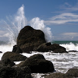
As soon as we turned north on the coast and left the Hoh River behind, we found ourselves walking on an immense beach. We could see far in the distance plenty of rock formations at sea. Our first highlight came shortly after that when we got to Diamond Rock, a conical rock right on the shore. We were close to the lowest tide of the day so we were able to get really close to it. Right after we had our first challenge, a rocky section that requires the tide to be below 2 feet to pass. Jumping from rock to rock, we made that section while watching the waves break into the rocks. It was quite the spectacle and soon enough, we were on the other side, walking on a sandy beach. Although Jefferson Cove is very inviting, it’s easy to see that staying there for the night could be a bit problematic if the tides get high enough. At the northern end of the cove, we found or first set of ladders, the other repeating theme of this trip. Looking at a map, you can see that there are numerous heads with rock cliffs down to the ocean. The only way to pass those is to climb over, hike on the forest and then climb down on the other side. Due to erosion and the steepness of the terrain, there are rope ladders on all these sections. After climbing the first section, we had a second where only the rope was available. Right after that, we landed on mud, deep mud. For the following couple of hours, while we hiked thru the forest to Mosquito Creek, we passed numerous muddy sections where our sandals would get caught forcing us to dig in and pull them out. This made our pace go a bit slower as we needed to keep our balance while sliding everywhere. Along this trail we got numerous views of little bays bellow us and a very lush forest. Finally we made it to Mosquito Creek were we found a nice, occupied campsite right next to the creek. We hiked back a bit to another big campsite right above the coast line to stay the night where we had some really nice views of the coast.

Looking South towards Hoh Head from the campsite


After setting up camp, making a run to get water and having dinner, we enjoyed a spectacular sunset. Mark and I, looking for better or different views, climbed down to the beach and follower it south to the end and climbed over a small head to a small cove on the other side. It was a perfect way to end the first day of our trip.
On Saturday, we started by climbing down to the beach and hiking north on the soft sand. We crossed Mosquito Creek and continued on with looming grey clouds above us. On this long walk we passes more rock formation on the coast, one resembling a fin and others looking like spears. As we walked, the weather seems to be unsure of what to do, whether to give us some rain or some sunshine. Towards the end of the beach, we passed by one of the bigger rock outcrops that looked like a little island. On this rock, some vegetation was able to grow and you can easily see a complete ecosystem surviving right there. We got to the end of the beach roughly at noon so instead of going ahead and climbing the stairs, we decided to explore a small cave on the left side and have lunch in it. That proved to be a wise decision as it started raining while we were there.

Mark and Brian in the cave where we had lunch


After lunch and the rain, we headed up the rope ladder as we needed to hike around the head and cross Goodman Creek. This section of the trail is probably the most beautiful coastal forest I’ve seen. Not only has some of the biggest trees I’ve seen but also lush greens.

On our way to Goodman Creek


Once we got close to the creek, the trail got interesting. We had to switch back and forth many times as we walked on downed trees that have been carved to form the path. At some point, almost on top of the creek, we found ourselves climbing down next to a fallen tree that almost seemed like it was put there so you could climb down. We passed a small tributary to the main creek and more huge trees before we actually made it to Goodman. After crossing the creek a couple of times, we heard a small waterfall nearby and decided to walk upstream to find it. Looking at the map latter we learned that this is Goodman falls, a small multiple stream waterfall that probably dries up in the summer. After that, we continued walking thru giants and mud and eventually passed by the biggest tree I’ve seen. This particular tree had roots that actually looked like separate trees attached to the main trunk. Looking up, you could see other plants growing from the branches of the massive tree.

The biggest tree


Soon after, we were back on the beach walking towards Toleak Point. This point is a very shallow head that, when the tide is low, rises above the surface showing a big field of rocks. We made a stop here to explore a bit while enjoying the views to both sides. Towards the south, we could see the head where Goodman Creek is and the rock with the natural arch. To the north, we could see Strawberry point and the Giants Graveyard. While we were sitting on the rocks, we noticed a couple of seal popping their head above the water and looking at us.

Toleak Point


We continued on the beach passing Strawberry Point, another huge rock formation on the coast line and headed towards Scotts Bluff where Scotts Creek dumps its waters into the sea. I can say this last section is probably the iconic part of this trail where you have the bulk of the rock formations out at sea. Being Saturday, we got to Scott Bluff only to find most, if not all of the campsites already taken by weekend warriors that come here just to spend a night in the coast. Just before the trail turns back and goes uphill, we found a small space, big enough for our tents where we were able to set up camp. The advantage was an incredible front seat view of the ocean and another spectacular sunset.

Early morning view towards the Giants Graveyard from my tent


Sunday came and our time to hike the last portion of this trip. Since we were almost right next to the next head, we started hiking up gaining considerable elevation and then descending on the other side to Second Beach. Here we got more great views and more rock formations until we got to Taylor Point. I did remember from my first failed attempt that at this point, you had the chance to go over the rock formation using rope ladders or actually hike around the rock, getting your feet wet and crossing a small cave. Having very adventurous friends with me, we opted for the later. We found a tree that had fallen into the mouth of the cave so before we could even get in, we had to break a lot of branches and clean the path to climb down to the cave and walk around it. Once on the other side, we sat for a while in a tiny rocky cove before heading up the rope ladder. While resting, a deer came down from the mountain and passed by and around us and then climbed back up on the other side. Although it’s known that there’s deer in the coastal forest, is not a sight we were expecting. Then we climbed up on got our last view of second beach and Strawberry point. Half way thru the forest we got a glimpse of Third Beach, our last section of coast line before hiking out to our car.

Third Beach


Once at third beach we felt like the hike was over. Being the first beach you get to from the trailhead, we found a lot of people that erased from our minds that sense of wilderness we had the previous two days. Still it was a comfortable hike to the trail and then back to the car.


You can check the pictures here

Interactive map

To see the full map, click Menu and select Full Screen. You can also click Terrain to change the map style