Tarbell Trail to Hidden Falls, Jun 14th

After the long hard hike I did on Saturday, I started this one having second thoughts as I was already tired. Lucky for me I guess is that I had people waiting for me to do this hike which, by its description sounded interesting and not very hard. The Tarbell trail is a loop on the Northwest side of Silver Star Mountain; in fact, you can reach the summit from this trail. Our plan for the day though did not include that. The idea was just to get to Hidden Falls and back. Besides going to “Hidden Falls” which sounds interesting enough, the other thing that picked my mind about this trail is its history. It seems that way back there was a mister George Tarbell that lives in the area. He was an old hermit living by himself up in the mountain looking for gold and cultivating the land. His only communication with the outside world was a faint 6 mile trail that lead to an old wagon road. Today there are no remains of where he lived or the wagon road, but the trail is fairly the same hence the name. AS you’ll see in the pictures, the trail starts by crossing a clear cut area and soon after gets into the forest. From there, it wonders passing through areas with tall trees and some open areas with wildflowers. At some point you get to a bridge that gives you a clear view of Hidden Falls, a very nice water fall almost carved in the rocks. Since this was our destination, it was also a perfect place for lunch. I took some extra time for pictures which you’ll see below before we headed back to the car.

North Siouxon Creek to Black Hole Falls, Jun 13th

The Siouxon Creek is located on the Washington side just south of St Helens. This Creek offers a couple of trails, the lower and known and the north or upper which is far less visited and known. Doing a bit of research, I found that the access roads for both of these where blocked due to a land slide in forest road 54. That almost made me cancel the idea of going this hike. Still, going to “Black Hole” falls had some attraction to it so I dug a bit more info and found that there was another road on the north side of the Siouxon Block that gave access to the trail I had in mind. Just in case that road was blocked as well, I had a plan B to due the same trail but in reverse from the Mt Mitchell trail head. In the end, the road was closed so we had to go with plan B. Probably all this gibberish I just explained doesn’t mean a thing to you but, it helps me picture the fact that this trail is not very well known. So after a long drive, we finally got to the Mt Mitchell trail head and started our hike up. I’ve done Mt Mitchell in the past and know it offers great views that I still have to enjoy. This time was no different as it was cloudy and foggy. About a mile and a half in, we took the detour that would take us to our destination. The first portion was normal as we crossed a very dense forest which suddenly disappeared behind us when we started crossing a huge clear-cut. Unlike other clear cuts, this has actually grown some new plants and it was covered by what I believe to be Death Camas. The hike continued passing numerous forested areas and other sections of the clear cut until we reached an old logging road where we stopped for break and eat something. It was quite strange that, although the map indicates the trail is open for bicycles, horses and hikers, it didn’t seem to clean. We were in for a big surprise, as a Kim described the hike; it was like a 12 mile obstacle course from that point on. Although we were mostly going downhill, we had to bushwhack our way through some heavy brushes and downed trees until we got to the forest. Thinking that once on the cover of big trees it would be easier, it actually turned for the worse. I can safely say that you couldn’t do more than 100 feet without having to go over a tree or branch. In the pictures you’ll see what I mean as there is a sequence showing just that. Later we finally got to the Siouxon Creek which was surprising. Most creeks have a bed of loose rocks and gravel, this one, is just one big rock with water flowing over it. That makes the water incredibly clear with small falls all around as water finds its way downstream. To pass the creek we had to use the remains of a very old bridge that is about to fall. After that, it was more of the obstacle course towards the falls. I thought that being so secret, we would have to find our way thru the forest but we wee surprised to find a rather large sign indicating the route to the Black Hole. Yes, the hike was brutal but the payoff was incredible. I don’t think I can find words to describe the beauty of this water fall that is secluded and cut in the rocks. You’ll se I took several pictures (I actually posted about a third of the pictures I took) just trying to capture the colors and the water. The return was pretty much the same trail, so we went uphill through our obstacle course all the way to the car. This was an amazing hike although I have to say that I’m a bit disappointed for the way I found the trail. I guess not having access prevents any work party from getting there, but for the state it’s in, I would say it just has been forgotten.

Ruckel Ridge – Ruckel Creek loop, May 31st

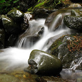
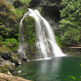
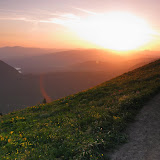
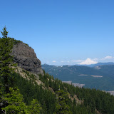
This hike is considered as one of the hardest hikes in the Columbia River Gorge. Part of it is because the ridge is very steep and part because in some section you can barely identify the trail. This day though, there was a third factor that made it even more difficult, heat! Ruckel Ridge is located just east of Eagle Creek, in fact, not only you part in the same place but you have views of the Creek all the way up until you reach Benson Plateau. The first portion of the climb goes thru numerous switchbacks deep in the forest until you reach the ridge with the first view point (The first couple of pictures from this hike are from that viewpoint). From there on, as you climb up on the ridge, you come out of the forest in several places with more views of the Eagle Creek valley and Bonneville Dam down bellow. After the second viewpoint and less than halfway up, we were already in the 80s so we knew we still had a long, hard hike ahead of us. The hike up continued pretty much the same with deep forests and open viewpoints until you get to the catwalk. This section is a rocky ridge that you have to cross before continuing on the last portion of the climb before reaching Benson Plateau. In most hikes like this, it’s sometimes difficult to know when you have reached the top. This was not the case in this hike. Once you reach Benson Plateau, even if you don’t have a map, you are pretty sure you are there as it’s completely flat. From there, the trail heads East thru the forest and descends a bit towards the creek. It was a very nice surprise to find snow in the creek and a much cooler temperature which made it perfect for our well deserved lunch stop. After resting for almost an hour while we enjoyed lunch and a bit of sun, we continued our journey toward the Ruckel Creek trail. Once there, descending is quite fast as you loose much of the elevation in a very short section. As with the Ruckel Ridge trail, this trail also goes thru some deep forested areas and some very open meadows. Vegetation is a bit different though as this side of the creek is far more humid that the ridge. After walking for a while, the trail opens up to a big meadow that had some wildflowers but was not very nice to walk on. With the intense sun shining on the hill, passing thru the meadow seemed more like torture than enjoyment. That was clearly market by a lot of sweating even though we were going downhill! After a while we got back in the forest (and a nicer temperature) and started heading towards the river quickly before hitting some switchbacks. On several occasions we came to corners with great view of the eastern side of the Gorge and Bridge of the Gods. The hike continues down and passes thru a big rock slide where you can see a couple of Indian pits. These are holes in the ground lined with rocks that where used by Native Americans in their vision quests. Then we continued down until finally we got to the creek and then the parking lot. A very long day.

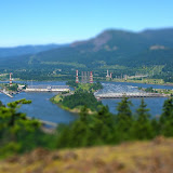
BTW, you’ll see that I included some TiltShift pictures in the set. This is a technique where you "bend" the lens of the camera to take the picture so the subject looks like a miniature. Since I can't do that with my camera, I used some photo editing software to create the same effect. Pretty nice eh?

Sunset hike to Dog Mountain, May 24th

Dog Mountain, for those who don’t know, is probably the most known hike in the Gorge. It’s located in the Washington side offering great views of the Columbia, but what makes this mountain special is that, this time of year, it’s completely covered with wildflowers. I hadn’t done this one yet as I wanted to avoid the crowds you normally encounter on this hike. I had been told before that it’s often difficult to find a parking spot and if you do, then you might get stuck behind a group of hikers doing a much slower pace. Being Memorial day weekend, with warm and sunny weather, it seemed perfect for this hike so Chris, Dallas and I came up with the idea of doing it late in the afternoon to avoid the crowds and enjoy the sunset. We invited Shawn and Scott for this as well. Timing the sunset, we met at gateway and carpooled to the trailhead just in time to start our hike at around 6 in the afternoon. Going up we found just a couple of hikers on their way down before we realized we had the mountain to ourselves, clearly something very rare in Dog Mountain. The first portion of the hike is an uneventful climb through a very dense forest with numerous switchbacks and constant elevation gain until the trail opens up and you see the sky up ahead. Just there you get the first glimpse at the hill next to you completely covered in yellow flowers. At that point, there’s also a nice overhang with amazing views of the Gorge and the rest of the trail going uphill towards the summit. In the pictures you’ll the flower cover on the west side of the mountain with the Columbia running below. After a bit over two hours keeping a grueling pace, we got to the top just in time for the sunset. One thing I miss calculated was that, at the elevation we where and the wind, temperatures where far lower than what we found at the trail head. Luckily Scott had an extra fleece that I borrowed while we stayed up there. After a short photography session, we got our stoves out, cooked some dinner and made some hot cocoa to warm up a bit. Soon after that, we packed everything and started our way down with the remaining light getting back down hiking in the dark with our headlamps. Truly a fantastic hike and probably the best way to enjoy Dog Mountain.

Table Rock, May 23rd

This is not to be confused with Table Mountain in the Washington side of the Columbia Gorge (as most people do). Table Rock is a columnar basalt formation near Molalla in the Table Rock wilderness. Interestingly enough, this wilderness is less than an hour drive from Portland and still, it can offer some really nice views of the central cascades. Getting there is rather easy although the last portion is a dirt road that ends near “small slide”, a slide that blocked the service road and was never repaired. After parking there and passing around the slide, we continued on what’s left of the old forest road until we found a post indicating the actual trail head. Form there; we got immersed in the woods doing a steady climb with snow patches around us. Shortly afterwards, we got to the first rock formations and some slippery snow fields. Chris took the chance here to boulder a bit. Right after passing, we found a small detour that allowed us to climb to the top of the same rock formation for our first view of the valley, Mt Hood towards the north and Mt Jefferson towards the east. We also had our first glimpse at the summit of Table Rock. We then got back to the trail and after crossing a deep forested area; we came to an opening right in front of the wall and an immense snowfield that we had to go around to continue our hike towards the top. In a coupe of pictures you’ll get a clear idea at the size of the snow field and the whole rock formation. It was quite a view. After maneuvering through the snow field, which was no easy task considering there was loose rock underneath, we were able to get back on the trail and continue walking around the base of Table Rock. Shortly after we found the trail to the summit but after a couple hundred yards we lost complete track of it due to the snow. We ended up bushwhacking all the way to the ridge and then to the top of the rock. Needless to say, once you reach the top at over 4800’ the views are just incredible. Being a bright sunny day and past noon, the summit became the perfect spot for lunch. After resting a bit, we went down and actually were able to find the trail we lost on the way up making the whole thing a lot easier. From that point on, the idea was to continue to Rooster Rock, columnar basalt further on the same trail but after some more bushwhacking and scrambling over snow covered rocks, we decided to take a second break and then head back to the cars.