Pocket Creek, Dec 5th

Having done most of the most recognized snow routes in the Mt Hood area, I wanted to try something new which obviously meant more driving. Pocket Creek is located on the Eastern side of the mountain right after Teacup Lake. Both of these places, but specially Teacup, are reserved for cross country skiers as the Nordic club grooms these trails. From Pocket Creek, there are a couple of trails that are not groomed and seemed to offer great views with a descent workout. From the parking lot, we started snowshoeing on a forest road up the hill. At first, the views were not very good but right before we got to the first turn off to descend to Teacup, some views of the valley opened up. About half way up, we found a fork that, on one side goes to Bennet Pass which would require a longer day and a car shuttle, and a road that goes uphill for a while until it ends at the Pillory Vista which we took. The hike up was as expected quite the workout. The views of the valley of the hood river were splendid but we completely missed the views of the mountain even on the couple of minutes that we got blue skies. There’s plenty to do in the area and I did notice a creek so some backcountry snowshoeing will probably happen in the area before the season is over. One thing that did stand out though was the face in the snow. That was really cool


You can check the pictures here

June Lake, Dec 4th

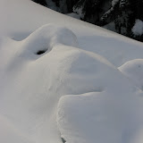
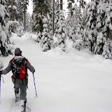
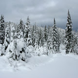
On one of my previous hikes, I met Debby, a fellow hiker and amateur photographer. On that hike, we talked a lot about photography and within that conversation, she told me about photography Meetup group that she belonged to. I checked it out, joined and went with them to June Lake up in Mt St Helens. I knew about this place but had not gone to it because it’s a fairly long ride and not too much hiking, but since this group was going there to take pictures, I figured I could do some exploring around and also take time to take pictures on my own. The hike, as expected was short even considering we had to add some distance to get to the summer trailhead as the road was closed for the winter. On the hike there we crossed the creek that comes down from June Lake and had some magnificent views of the south side of Mt St Helens as it was barely creeping thru the clouds. At first, weather was not cooperating well but then we got a small break with some interesting lighting that allowed us to get better shots. Once we got to the lake, we were welcomed with a partially frozen surface and untouched snow. Tripods, big cameras and lenses came out and we started shooting like paparazzi. At first we were looking at one side of the lake where you can hear the waterfall that feeds it but you can’t see it. Walking a bit further, we got to an angle view that allowed us to peek into the hidden fall. It was a magnificent view.

View of the Waterfall


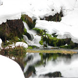
From that same angle, all of tried to zoom in to the lower portion of the fall where the water dumps into the lake as that was the most scenic portion of the whole thing. While that was happening, I noticed there was a possible way to walk around the lake and get closer to the fall. As I did, I traversed thru a steep slope with over hanging icicles that looked like menacing teeth. Shortly after that, I found a semi-flat spot on the other side where I got a better shot of the lower section of the fall.

Lower section


From there, I pushed on a bit further and got to very base of the waterfall. I wasn’t able to take many pictures from that angle as my lens was getting wet, but I was able to look back at the other side of the lake where the rest of the group was. After a couple of hours of intense picture taking and being satisfied with the views, we headed back the way we came back to our cars


You can check the pictures here

Yellow Jacket, Nov 28th

This is one of the classic snow shoe routes up in My Hood. In the past, all the times I’ve done this route, I’ve started from the Snow Bunny Sno Park and done an out and back which covers probably the more interesting part of this trail. But, if you look at a map, you’ll notice that this trail is a lot longer giving the ability, by connecting with other trails, to do a complete loop. I have already explored most of the connecting trails in the White River Basin and Barlow Pass area so I wanted to check the portion between Timberline Road and White River. Since this would be a long day if you wanted to come back, I decided to plan this as a car shuttle leaving half of the cars at the exit point in white river and then parking the rest at the entry point in the Summit Ski area. After all that logistic, we finally hit the trail at around 11AM on a mild day with good snow. The first portion was easy to navigate as I was following the tracks of someone that was ahead of me. I learned quickly that whoever it was, it was not going to the same place I was going so at some point, I had to correct and start navigating off-trail thru the woods. The group was doing very well although some started to show signs of being uncomfortable which irritated me a little bit. I can understand as a lot of people don’t feel comfortable not knowing where they are going or how long will it take to get there. As we were navigating thru the woods, we had to cross several small creeks that were not completely covered with snow. That was the first sign that we didn’t have enough snow on the ground yet. About two hours after we started, we finally found the road that you take if you were to start from Snow Bunny. This was obviously a relief to all as, among other things, I knew the trail very well from that point on. We made a quick stop for lunch under the trees that was cut short as it started to snow a bit. Then came the marching part. One of the key things about the Yellow Jacket trail is that it doesn’t have a lot of elevation gain but it does have a lot of ups and downs making it relentless. For a couple of hours we just marched on until we reached a traverse section that then descends steeply to the creek below. In normal snow level, the creek is completely covered to the point that you can’t identify where it is. This time though, it was clear to us where it was. While looking for a good crossing, I felt into a big hole almost to my shoulders which wasn’t that bad until someone else fell besides me and sink just as much. I was able to get good footing and get out and then had to get the other hiker out. Clearly that was not the best place to try to cross. We hiked upstream a little bit and found a bent tree spanning across the creek. As you’ll see in the pictures, it was an interesting way to cross. From there, we had to just keep a good pace as it was getting dark fast. Finally we made it to the parking lot just in time to get in our cars before it started snowing really hard.


You can check the pictures here

Hamilton Mountain, Nov 27th

When you drive on Hwy84, you see some prominent points on the other side of the river. From those, Table Mountain and Beacon Rock are probably the easiest to recognize. The mountain that sits right behind Beacon Rock is Hamilton Mountain. In this area there are more than a handful of trails but the one that offers the best views if obviously the one that climbs to the summit of Hamilton. This is not only because you get the views from the top but also because the trail is fully exposed with ample views of the Columbia River Gorge. As with many of my hikes, this was planned knowing that weather up in the mountains was not going to be very favorable for snowshoeing and that the Gorge was going to be drier. I was also expecting to find ice, with the wonderful scenery that goes with it. So we started on a very cold and cloudy day. You’ll notice in the pictures that we made a quick stop along the road to take pictures of the gorge fully immersed in the clouds. Soon after, we were on the trail and it didn’t take too long to realize we needed traction devices to stop ourselves from just sliding off the trail. Soon after, we got to the section of the trail that goes under the power lines and were welcomed by a completely frozen mountainside. I think there’s no better description for a frozen forest than this. Every single branch of every tree was completely covered in a layer of ice. The views towards the Gorge were also impressive as we were already above a layer of clouds. We continued up enjoying the fast moving clouds bellow us and soon reached Hardy Falls and took the detour to visit the Pool of Winds. Then came the uphill. Since we wanted the views, we took the hard route up the follows the open ridge line all the way to the summit. As we were gaining elevation, we started to change from ice to snow to the point that the trail to the false summit or what is also referred as to Little Hamilton, was almost impossible to see. To keep us safe, we decided against taking that route as we would have not known if we were walking on solid ground. Once we got a bit higher, we were able to look back and see the ridgeline to the false summit and got glad we didn’t take that route. Not only the ridge was completely covered in snow/ice but there was a bit of drift on one side. It was still a magnificent sight.

Snow drift on the false summit


From there, there was a short jaunt to the summit which I must say; it’s probably one of the most disappointing summits you can get to. As I said before, the views are great but usually you expect a bare summit with 360 views. Hamilton is not bare so the summit is actually on the side giving you a 120view, the rest is left to your imagination. From there we had two options, go back the way we came, or take the easier route that goes around the back of the mountain. We opted for the second choice which took us thru the ridge that connected the summit with the mountain behind. To do that, we had to go thru deep snow for quite a while which was no easy task but then we got to the saddle that offered ample views of Table Mountain. We connected that to the trail that comes back down from behind and hiked all the way down to the car just as the little light we had was fading out at the end of the day.


You can check the pictures here

Wahkeena Falls, Nov 25th

I’m so far behind with this that I’m even thinking of skipping some of the hikes I need to report! I guess I’m hiking too much and don’t have a lot of time to write. I guess that could be seen as a good thing. My original idea for Thanksgiving was to go backpacking somewhere but weather wasn’t looking good so I had to cancel. Looking at the calendar in the group I saw that Brian wanted to do the classic hike from Multnomah Falls to Wahkeena so I decided to join. I usually like this hike counter clockwise as I like how the creek just disappears in front of you when you get close to a waterfall. Brian though about doing it in reverse so we could get the section of the trail that goes next to the road out of the way first and then enjoy the upper section. With that in mind, we parked at the Wahkeena trail head and took the connector trail to Multnomah. This first portion gave us a quick glimpse of what would be ahead, ice and icicles! It felt a bit strange when we got to Multnomah that there weren’t many cars. Then we noticed that the restaurant and lodge were closed, the store was closed and even the little coffee shop outside was close. We found a couple of trail runners coming down that told us the gate on the trail was also closed which was a bit of a bummer. Although there was no indication of it, we assumed it was because of the holidays and the ice on the trail. In a map in Multnomah, we saw there was another trail further down the road that would connect to the main trail so we went out trying to find it (walking on the historic highway). Well,, we didn’t find that trail so we turned back and as we passed Multnomah, we went to check the map again and saw the little letters on the bottom that said “Map not to scale”… I guess we deserved that. After all that process, we hiked back to the Wahkeena trailhead and started from there. As expected, the scenery was beautiful with frozen waterfalls and icicles. The hike was much shorter than our original plan but still we made it to the Wahkeena springs and had the mountain to ourselves. On the way back though, we had another eerie moment when we got in the cars and started driving back to town. As we were driving, we noticed there weren’t many cars on the highway, in fact, there were none. Then we saw, a couple of miles down the road that they were shutting the highway down due to a weather system coming in. I guess we got lucky and were able to get back home safely. Lesson learned, look for small letters at the bottom of maps!


You can check the pictures here

Mineral Jane, Nov 20th

Although the snowshoe I did on November 13th to Twin Lakes from Barlow Pass was the official first snowshoe of the season, I would say this one was a real snowshoe. After a couple of days of heavy snowfall up in the mountains followed by a cloudy but dry day it was only logical that we would find good conditions. I picked the Mineral Jane trail knowing that few people go that route which gave us a better chance to break trail. We started from the Barlow Pass Sno-Park and immediately thought we wouldn’t have enough snow. The trail starts on a forest road that, later in the season, you can barely make. This time, being so early, it only had a couple of inches of snow. All that changed as soon as we veered off on the trail towards Barlow Butte. At first we started traversing on 6 to 8 inches of fresh powder that quickly went down to almost nothing at the junction between Barlow Butte and Barlow Road (Could they come up with different names?). For the first time ever, and I have done this trail more than a couple of times, we were able to see the sign and he board. From that point, the lowest in the entire trail, we stared climbing again on the Mineral Jane trail to the fork with Barlow Ridge. By then, we were in deep fluffy snow and spectacular winter scenery. We took a short break at the fork with the Barlow Ridge trail and took some group photos before continuing on the mineral Jane trail. Shortly after the fork, we found the second fork but decided to explore further on the road. That lead us nowhere interesting, so we turned around and took the side trail that had pristine new snow for us to break. After a short lunch stop, we continued on the side of the creek looking for a good spot to cross. We found several logs that looked promising so some of us crossed on them while the rest of the group, counting on the low waters, just crossed the creek. From that point, everything got even better. We got deeper snow, more untouched trails and even some bushwhacking. We crossed the creek at least a couple more times. As time was going by, we had to decide whether we wanted to continue to white river and loop around (which was my original plan) or head for the highway and hike back to the parking lot. We all went for the second option which was not the most appealing but the one that would get us back quicker to the cars. While doing that, it occurred to me that it would have been a lot better to organize this as a car shuttle leaving half of the cars at Barlow Pass and the other half at White River, oh well, maybe next time.


You can check the pictures here