Cooper Spur, Jul 18th

100 years and 1 day after the historic first climb to Cooper Spur, I decided to take a group up there. The idea was not to celebrate the 100 years though, that happened by chance. The idea behind this trip was to train for the Adams Climb planned for the end of July. I was hoping to get most of the group that had already signed up for Adams but instead, I got a mix with some other folks that were not doing Adams. This hike, which I have done at least three times in the past, it’s a grueling climb from the Cloud Cap Inn in Mt Hood to the base of the Elliot Glacier at 9000 feet. The first part of the hike goes thru some switchbacks in the forest but quickly comes out of it and for the rest of the day; you are out in the open. This can be good and bad at the same time. As you’ll see in the pictures, the good thing is that you get amazing views that just get better and better as you gain elevation. The bad thing is that you have either the full sun on your back, cocking your brains or, on cold and windy days, the wind. Also, when you come out of the forested area, the hike is over a barely noticeable trail that goes over scree and mountain ash. This makes the hike a bit harder as every step up you take, you slide down a bit. With all that, we marched on at a steady pace towards our goal. In several places, we took the standard route doing switchbacks thru the snow but on some others we took the harder/shorter route following the ridge. The view where outstanding as we got up to the low section of Cooper Spur. At that point, we decided to stop for lunch and enjoy the views and then some of us continued a bit higher to the point where you need to put crampons on to continue. The wind was blowing hard so we didn’t stay there for long. On our way back, we stopped at the famous rock with the inscription done 100 years ago before heading down. Once we got back to the ridge line, we saw a group of people heading down over the snow field. That seems to be more fun that hiking down the scree so we traversed a bit to the east and glissaded most of the way down. After all that fun, we, the ones that were signed up for Adams, knew e were ready for that challenge.

Table Mountain, Jul 10th

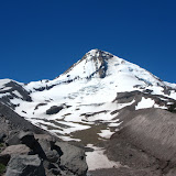
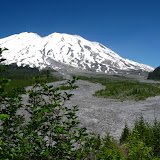
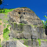
The grueling hike to table mountain is one of those that, after you’ve done it, you really think about it before attempting it again. To get to the summit, there are several routes, the short and hard, the long and hard and the approach via Aldrich Butte (also hard). For this hike, I was just following the directions of Zach, a new hike leader in the group. He decided to take the Aldrich route via a connector trail that shortens the approach a little bit. We started on a gorgeous sunny day thru the forested area that leads to the Trail of Two Chiefs and soon departed on the PCT towards Table Mountain. This first section, been all under the canopy, doesn’t offer a lot of views until you get to the ridge. Once there, you are welcomed with a nice panoramic view of the Columbia River and Mt Hood peeking between the trees. After a short brake, we continued up the hill to the ridgeline and found the spot where Kate Huether had an unfortunate accident and fell, a clear reminder that you have to respect the outdoors always. Soon after that, we came to the rock field, a section of the trail where it’s better to put your trekking poles away and use your hands and feet to scramble up the rocks. The jaunt doesn’t stop there though. AS you pass the rock section, the trail continues up steeply until it reaches a saddle with the top of Table Mountain to the right and wonderful vistas that include Mt Hood, Mt Adams, Mt Rainier and Mt St Helens. We followed the ridge to the top of Table and unexpectedly were welcomed by an incredible flower bed. That plus the views of the Gorge from the edge were just fantastic. For the return, we hiked back up the ridge line to the back of Table Mountain to do the north trail which is almost as steep as the south trail but offering a different panorama of the area. Just before heading down though, we decided to stop for lunch at that end, enjoy the views and the sun. Yes, my knees were hurting a bit the following day!

Quartz Creek, Jul 3rd

While researching some trails, I found a bit of information on Quartz Creek which caught my attention. This creek, located in the Dark Divide, seemed to be exceptionally beautiful but seldom visited. I found conflicting information about the state of the trail so I didn’t know what to expect. Most reports did say that the trail was unmaintained but I also read that it was a backpacking possibility. Not wanting to experiment that particular weekend, I decided to take a small group on an exploratory hike up the creek to find out. Getting to the trailhead went smoothly and easy as this trail starts from the upper Lewis River. As soon as we found the trailhead, we were surprised to see it was well marked and clear. The first part of the hike was like hiking on any other trail although we crossed a couple of bridges that haven’t seen a bit of care. Things started to change as we got closer to the first obstacle. We knew that we needed to cross Straight Creek that has on bridge, but just before that, we found the first blow down. It wasn’t that bad but a sign that things would change after that. We took a small detour to an overlook of the Quartz Creek before continuing on to the creek. Straight Creek was unexpectedly beautiful. The river bed was a yellowish rock which made the whole section look golden. At that time we didn’t want to get our feet wet so we hiked upstream and found a log pile that made it easy to cross although we had to pay the price for that afterwards. The short section we hiked upstream on one side of the creak was a heavy bushwhack on the other side to get back on the trail. Once there, we started ascending and found the first campsite. From there, all things changed. What seemed to be a well maintained trail changed to a seldom visited place. First we started finding some blowdown trees that as we went on, became larger and more frequent. We even got to a section where we found to old growth trees, one on top of the other, crossing the trail. Once we climbed over those two trees and found the trail on the other side, we came face to face with three more crossed old growth trees. Some later sections were even more challenging as the trail became invisible for more than a couple hundred yards. At some point we got to the second creek which was one of my intended turn around points. This creek, the Snagtooth Creek, is much smaller than Straight Creek and, although there’s no bridge, it’s much easier to cross jumping from rock to rock. Being in the shade and cool, we decided to stop there for lunch before continuing. From Snagtooth Creek, we continued up until we found a fork. At that point, the trail can continue up to the boundary trail o veer to the right down to Quartz Creek and then to the Quartz Ridge trail on the other side. We decided to continue towards the creek where we found a third campsite. We stayed there for a while before heading back out the same way we came in. On the way back, the only change was that we actually crossed Straight Creek instead of walking on logs. Damn that water was cold.

Ape Canyon, Jun 26th

Ape Canyon, located on the south side of Mt St Helens is one of the clear signs of the destruction caused by the volcano when it erupted in 1980. The hike is nothing but impressive as you get the full view of Mt St Helens and the mudflow. Soon after starting we got our first glimpse at the vast section of rocks and dirt and the first peek at the mountain. The trail followed the forested ridge climbing fast but always with clear views of the mountain up to a view point that opens up the whole scenery. Not only the mountain is impressive but you can see the muddy river in the middle and the vast destruction of the mudflow. From that view point, the trail cuts to the east side of the ridge, giving you a complete different view. On that side, there’s no destruction but the green valleys of the Dark Divide. Soon after that scenery, we got to the Lowitt trail (the trail that goes around Mt St Helens). With plenty of time, we decided to continue on towards the Plains of Abraham, a huge plateau on the south-east side of the mountain. That place was from another world. As we got in, the only thing we could see was a vast flat area covered with rocks and dirt, nothing more. WE crossed the plains until we got to the fork with the Windy Ridge trail where we stopped for a short rest. While some took the time to take a nap, I went up the side hill to take some higher elevation photos. I was surprised by the views I got. Not only was I able to take in all the plains, but also look to the other side, towards the Dark Divide and even South to Mt Hood.