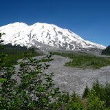
Ape Canyon, located on the south side of Mt St Helens is one of the clear signs of the destruction caused by the volcano when it erupted in 1980. The hike is nothing but impressive as you get the full view of Mt St Helens and the mudflow. Soon after starting we got our first glimpse at the vast section of rocks and dirt and the first peek at the mountain. The trail followed the forested ridge climbing fast but always with clear views of the mountain up to a view point that opens up the whole scenery. Not only the mountain is impressive but you can see the muddy river in the middle and the vast destruction of the mudflow. From that view point, the trail cuts to the east side of the ridge, giving you a complete different view. On that side, there’s no destruction but the green valleys of the Dark Divide. Soon after that scenery, we got to the Lowitt trail (the trail that goes around Mt St Helens). With plenty of time, we decided to continue on towards the Plains of Abraham, a huge plateau on the south-east side of the mountain. That place was from another world. As we got in, the only thing we could see was a vast flat area covered with rocks and dirt, nothing more. WE crossed the plains until we got to the fork with the Windy Ridge trail where we stopped for a short rest. While some took the time to take a nap, I went up the side hill to take some higher elevation photos. I was surprised by the views I got. Not only was I able to take in all the plains, but also look to the other side, towards the Dark Divide and even South to Mt Hood.

No comments:
Post a Comment