Barlow Ridge, Apr 4th

If you have read my posts, you’ll probably notice this is not the first time I’m writing about Barlow Ridge. I guess this has become one of my favorite places to go snowshoeing as it offers a bit of everything. From the parking lot, you get a nice downhill to begin with before you get deeper into the forest, but just as you think you’re not going to get a lot of views, you get to the Mineral Jane and eventually to the Barlow Ridge road. From this point, the trail is a steady uphill with multiple views of the white river basin and Mt Hood on clear days. From this road, you can return at any time, but what I’ve found to be more interesting is to go all the way until it forks with the lower branch going to Teacup Lake while the other, less visited road, continues up. Somewhere along this road, you can veer off for some backcountry traveling and here is where you can find peace, solitude and deep snow. On this trip I retraced pretty much what I did last time so eventually we got back to the same viewpoint above the trees. Now that I’m getting my bearings right in this area (this time I did the hike without even looking at the map), I know that the peak in front of the viewpoint is Barlow Butte. Maybe next year I will be able to do the loop as I want to do it which basically includes getting to this viewpoint to then traverse to the rock formation south of the butte and continue to the Butte. From there, instead of going down to the road, I imagine you can do a straight line back to the parking lot. We’ll see how it goes next year.

Mt Mitchell, Mar 27th

They say third time is the charm and this hike certainly proved that. Mt Mitchell is one of those little gems that are not that far out, not to long of a hike and not much elevation gain but with huge rewards. In the past, I’ve done this hike only to get to a summit completely immersed in clouds. On those cases, it was still rewarding as the top of the mountain is a flat rock bed with numerous rock formations around that are quite interesting. This time, it was quite the reward to get up there and actually get the views I had only seen in pictures before. As you’ll see in the pictures, the trail goes thru some dense forest with just a handful of viewpoints that offer hints of what you’ll find further up. About half way in, the whole forest opens up but, despite the fact that you can see all around you, you don’t get many expansive views. It’s until you are in the last section, just a couple hundred feet from the summit, that you get a good view north that includes Mt St Helens and the Swift Reservoir but that’s just half of it. Once you reach the summit, Mt Mitchell offers 360 views that also include Mt Adams and Mt Hood in the distance. Having those views with the rock formation I had seen before was truly a different experience. BTW, you’ll notice in the last couple of pictures we are in a cave. Yes, since this hike is not that long, some of us finished with a bit of room for more hiking so we decided to continue a bit further to the Ape Caves for a couple of extra miles.

Salmon River, Mar 21st

After a lovely hike on Saturday, I decided to take a group to an easy, close to town hike. For that, the Lower Salmon River seemed like a good choice. This trail follows the Salmon River on a gentle uphill that eventually departs the river basin to some outstanding viewpoints. I recall doing this hike several times with Shia a couple of years ago and it was always very nice. What I wasn’t counting on though, was how wrong the weather man was going to be. Sunday was supposed to be just a cloudy day but instead, we got rain almost for the entire hike. As soon as we got out of the cars at trailhead, it was a race to put on rain gear and head into the forest. The trail itself was very muddy but incredibly green with moss and ferns. Unfortunately, with all the rain, I wasn’t able to take many pictures on the way up and we were able to stay at the first view point for just a couple of minutes. Since it didn’t make a lot of sense to continue on those conditions (people were getting a bit cold) we decided to stop under the trees for lunch before heading down. Just when we did that, rain stopped for a while so I was able to take some pictures. Coming back down was a lot faster than going up in part because, well, you’re coming down but also because everyone was tired of the rain already. It ended up being a nice hike nonetheless and the dogs had a lot of fun.

Huckleberry Mountain, Mar 20th

It’s funny how things happen sometimes. AS you have probably noticed in my stories, I try to do something new every time. This time was no difference, so I did my normal research, looked at the weather, searched for maps, directions, printed my topo and went on my way thinking I was going to discover a new place. As I we were driving to the parking lot where the trailhead is, I started having a déjà-vu moment. I thought, well, maybe there’s another hike I did around here. But that feeling grew stronger as we started on a trail that quickly climbs to the ridge of the mountain. By then, it was clear to me that I had done this trail before but I was still baffled because it was not in my list. Everything cleared up when one of the hikers, Sean, told me he was with me that first time (I was not leading) and that he recalled that we were not able to go all the way to the ridgeline due to snow. He also recalled that the leader had called this hike Boulder Ridge which is the name of the trail that leads to Huckleberry Mountain. The good thing is that this time around, we were able to get to the top and see what we missed the first time. The hike was very well worth it and since we got there in record time (much faster than what I had expected) we took a long lunch before heading back down.

Huffman Peak loop, Mar 14th

Every now and then you embark on a hike that you know it’s going to be an interesting adventure and then you get surprised by it when you realize you underestimated it. Luckily the small group I had for this hike was up to the challenge and, although it took a long day, made it in good spirits to the end. While planning this trip, I knew it was a long hike and I knew we had to cross the Siouxon Creek a couple of times. This was not supposed to be a major obstacle as this river doesn’t carry a lot of water. What I wasn’t expecting was to find a lot of snow at higher elevations. The other thing I was hoping for, was to have two cars so we could do a short car shuttle between two possible entry points and shave 3 miles from this hike (without the car shuttle, the loop is about 15 miles). When we met, early on Sunday morning, it seemed for a while that it was not going to happen until Adam showed up. By then it was 5 of us so we had two cars and three miles less to hike. Getting to the trail was fairly easy although we started noticing a bit of snow on the road which wasn’t a very good sign. After leaving the cars in the respective parking lots, we headed on a short and nice trail down to the Siouxon River where we found our first challenge of the day. Upon seeing the river we took our shoes off and without hesitation crossed the creek. You’ll notice in the pictures that we were wearing sweaters and jackets and gloves… it was cold, just imagine how cold the water was. After that exhilarating wakeup call and getting dry and dressed again, we continued our route to the peak. The trail, from that point on, was a steady, relentless hill offering very limited views of nearby, snow dusted mountains and ridges. Despite the not so good weather, it almost felt like walking inside a cake towards the frosting. As we were gaining elevation, we started getting into deep some deep snow. This was completely unexpected as I thought we would only find a couple of inches at the highest point of the hike. The surprise was to find about a foot or more of fresh powder in most of the upper section. At some point we started wishing we had snowshoes with us. With all the snow, the trail became a bit obscure but Jocelyn who kept in front most of the time did an excellent job at finding it. At some point we came to an open slope that gave us the views we were looking for. We had, for a very short time, A wonderful, first row view of Mt St Helens. Shortly after that, we veered up for the last portion of the trail and found the unmarked summit of Huffman Peak. We were still in deep snow and not well equipped to make a stop for lunch right there so after regrouping, we started hiking down or a very steep ridge. As soon as we got out of the snow and found a sheltered area, we made a quick stop for lunch to then continue our trip down. As we were hiking, we started hearing a big waterfall nearby which I didn’t know we were going to see. At some point the mountain just opened in front of us giving us an incredible view of the Wildcat falls from the top. I wasn’t aware that this waterfall was a couple hundred feet tall so it was quite the surprise. The trail circled around a couple of times and eventually brought us to the base of the waterfall before heading back to the lower valley of the Siouxon Creek. As we were losing light, we crossed a small tributary to the Siouxon Creek and continued on what we thought would be a trail to a bridge that we never found. After about a mile of detour and realizing it was getting late and dark, we back tracked and crossed the river one more time knowing that a short bushwhack up would put us back on the main trail. Once there, it was only about three more miles to one of the cars. When we got there I realized that it had been a very good idea to have two cars as we came out of the forest in the dark.

Eagle Creek – Tanner Butte backpacking loop, Mar 5th

This weekend was pure luck I guess. I got a free day of as the company was moving to the new building and weather was just perfect to get out there for the first backpack trip of the season. Not wanting to go too far from town, we decided to stick to a closer yet very interesting loop in the Columbia Gorge. The Eagle – Tanner loop basically combines two trials in a big loop that that can be done in either direction both offering great places to spend the night and views. Having read some reports, I though the better way to do it was anti clockwise. Originally the plan was to start early in the morning although the first day was not going to be too long, but since Mark needed to finish some stuff at work, we actually headed out there at noon. After leaving the car at Eagle Creek, we started our adventure by crossing the bridge and getting on the Columbia scenic trail, also known as trail 400, which travels next to the river without gaining a lot of elevation. Incredibly and unexpectedly, we got some really good vies of the Cascade locks from this trail.

Cascade locks from trail 400


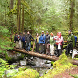
After a short walk we came to an old forest road which was the original access road to the Tanner Butte trail. This road has been closed for some time making this trail a bit more difficult to get to although you’re just hiking on a road. Then we got to the Tanner Butte trailhead. That felt like the real beginning of the hike although by that time we were already about 3 miles from the car. Either way, after reading all the warnings which seemed kind of funny as you can’t drive there anymore; we started hiking up around some small, beautiful waterfalls. AS we were ascending, we got a couple of nice views of Table Mountain across the Columbia River. From that point on, the trail became a magical passage through dense second growth forests with almost no views. That obviously didn’t matter much as the forest itself was incredible.

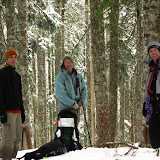
Hiking through the forest


Near the end of the day we finally reached the side trail to Dublin Lake, our destination for the day and campsite for the night. As expected, we had to descend a couple hundred feet to get to the lake which is immersed in the forest and has no views. Still, it’s a great stopping point with one of the nicest campsites I’ve found. Not only we had a huge fire pit, but we had a sofa! Given, it was made up of rocks, but after a full day of walking, it was great to sit and rest in front of the fire while having dinner before going to bed.

Campsite with a sofa


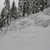
On Saturday morning, before breakfast, I went for a short walk around the lake to take some pictures. Being so deep in the forest and with a foggy morning, it was hard to get descent shots but it was easy to take in the serenity and peaceful setting of it. After a nice breakfast and packing up, we headed back up to the main trail to continue climbing to the highest point of our trip, Tanner Butte. On our way we made several stops to enjoy the different shapes and views within the forest. As the hours passed, the weather was getting better and warmer to a point, when we reached a meadow before the final ascend to the Butte, when we had crystal clear blue skies. In that area, we found remnants of rabbits and other small animals as well as the cause for those… Cougars! We didn’t see any, but the tracks were fresh. From there, we continued up looking for any sign or mark indicating the route to Tanner Butte. According to the maps, the Butte is not on the trail, so to get to it, you have to scramble. At some point Brian found the market although it wasn’t on a tree, it had fallen and was lying on the ground. I have to say that this may be the most descriptive sign I’ve seen in the woods.

Pretty clear what’s up ahead isn’t it?


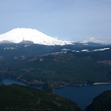
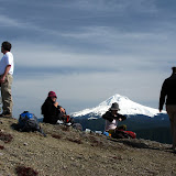
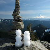
So we left our packs tucked away and scrambled our way up. Although not too long, the scramble is a bit difficult, but the rewards are very well worth it. As you start to get above the tree line, distant snow peak start appearing in the horizon. At some point, from the slope, you have a clear view that includes Mt Adams, Mt St Helens and Mt Rainier. Going a bit further, you finally reach the summit which opens views to the South with Mt Hood right in front of you. At this point, all I can say is Wow! The views were so amazing and the day so nice that we spent nearly an hour at the summit. Putting words to it would be difficult so I’ll let a couple of pictures tell the story

At the summit


Our cairn and snow people


Mt St Helens


After that, the trip was mostly downhill. First we needed to get back down to the trail where we stopped for lunch and then continue on the ridge to the connector trail. The sign was not difficult to find but after getting on the connector trail, which starts descending abruptly to the Eagle Creek drainage, we found that staying on the trail was no easy task. On one side it was over grown and on the other, we had snow on the ground so we ended up losing the trail. Doing some navigation we were able to get back to it just to lose it again a couple of times until we were below the snow level. Roughly by the end of the day, with almost no light left, we finally reached Eagle Creek which we had to cross as our campsite for the night as well as the rest of the trail, was on the other side.

Crossing Eagle Creek


The final day of our adventure was hiking down the Eagle Creek trail back to the parking lot. This trail is probably, next to Multnomah Falls, the most visited in the Gorge so we were not expecting a lot of solitude. What we were expected though was a lot of really beautiful waterfalls. From those, there was one in particular that Mark and Brian suggested I checked. This fall is not on the trail so you have to scramble a bit to the side to see it. But once there, I can say it’s just amazing. I was not able to take a picture of the whole thing, but just seeing half of it was impressive. Here’s some eye candy.


Then, more waterfalls, more green scenery, more beautiful forest. Could there be a better way to start the backpacking season?


My coimputer is almost fixed!

You might have noticed that I haven't posted anything for quite some time. No, I haven't forgot and yes, I've been doing a lot of hiking as usual. What happened is that my computer broke and I've been trying a lot of different things and it seems that finally I got to the root of the problem. My mother board was fried. So that is changed and now I'm in the long process of reloading all my software and then will have to process a ton of new pictures. Some of the later trips (with less pictures) I've been able to upload to picasa but there's one trip prior to those with over 300 pictures that I'm still working at. Once that is up, I will post it.