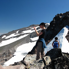
This area might not look like this anymore. A few weeks after I did this trip, a forest fire broke up and burned most of the area. Located in the north side of Mt Hood, this is one of those trails that offer a different perspective of the mountain. I can safely say that the first part of the hike, from the trailhead until you reach the Timberline Trail is like any other forest hike. You meander thru the woods with limited views, but this trail offers some nice streams and creeks that add to the beauty of the place. But then, just before you reach the Timberline trail and, in our case find our way thru mud, you get some interesting views of the cascade peaks to the north. Once on the Timberline Trail you have to look for a small cairn and a user trail to the right that climbs to Dollar Lake. Incredible enough, this is not an established trail despite the fact that a lot of people go that route, primarily to spend the night at the lake. From the Lake, that is located in a small basin, you don’t get a lot of views although you can clearly see the route you need to take if you pretend to climb to Barret Spur. After a short break and lunch we tackled that route with the intention to reach the saddle. That climb was arduous as it was hot and we were on an exposed trail. AS you gain elevation though, the views keep getting better and better. In the pictures you’ll also notice the dramatic change of scenery that goes from lush greens and valleys to rocky ridges and slopes. From the saddle we got an incredible view of the Ladd Glacier, Pulpit Rock and the top of the mountain. With the group, we decided to climb a bit more to the ridge to a higher point on Barret Spur. I had read you could go further than what we did but that would have been a bit dangerous. Still, from our return point we got some magnificent views of the Coe Glacier to the east and some amazing crevices down below. Indeed a hard hike but very rewarding with the views and scenery. For me it was even more rewarding. That’s the day I really noticed Val.
Interactive map
To see the full map, click Menu and select Full Screen. You can also click Terrain to change the map style
