I have to start by saying this was one of the best trips I’ve done. That is not only because of the location and scenery but also because it was a great experience for me. Learning like this that you can be out there for 10 days and be self sufficient feels really good and opens a whole bunch of possibilities. The whole idea of this trio started from a conversation with my good friend Jocelyn when she told me she was going to Peru and then Chile to attend NOLS down in Coyhaique. We almost immediately though about Torres del Paine as it’s considered as one of the best treks in the world. We started looking at dates and possible scenarios and considered either doing the 5 or 6 day “W” circuit that covers the highlights of the park which would have left us with time to maybe cross to Argentina and do part of Fits Roy or do the “Q” circuit which, besides covering the highlights, goes around the Paine Massif. Being explorers like we are, we opted for the second option. It’s better to cover an area well than try to do too much and miss half of it. So finally we agreed to meet at a certain date in Punta Arenas, travel to Puerto Natales and then head from there to the park for the 10 day trip. So while Jocelyn was down there getting her NOLS certification, I started training and getting my gear ready for this. I recall doing numerous hikes carrying a backpack with a couple of sand bags just to get used to the weight. About a week of, I started my final preparation by putting all my gear and food on the floor and trying to guess how was I going to fit all that in my bag. Surprisingly it did so I was ready to start the long journey. On my way south I stopped in Santiago for a day to visit my dad and the following day I flew to Punta Arenas (Punta Arenas is the southernmost point in Chile that faces south to the Magellan Strait). Once there I took a bus to town to meet up with Jocelyn and then another bus with her to Puerto Natales. Once we got there, we still had to go out and buy the last couple of things and get our gear ready for the next day. That night, just to relax a bit a think about the next 10 days, we took a short walk to the waterfront where we were welcomed with a beautiful sunset.
 Day 1: Park administration to Paine Grande
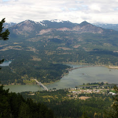
Part of the service provided by the Hostel we stayed in Puerto Natales was a “Hikers Breakfast” just before the bus came to pick us up and take us to the park. The ride took a bit more than 2 hours just to get to the park entrance where we made a stop to pay the entry fee. From there we continued to the first entry point where more than half of the people got of the bus to take the Catamaran across Lago Pehoe to Paine Grande. Since our plan was to do the whole circuit, we stayed on the bus as it went around the lake to the Administration office on the south west corner of the park. We were a bit surprised as the scenery was not showing much of what we expected to see. When you see pictures of Torres del Paine you see massive glaciated peaks and lakes. Instead, we were traveling around low ridges and mountains and lakes. Far to the north we could barely see a mountain range but the low cloud cover was keeping it mostly out of sight. Once we got the Administration office, I started raining so we stayed there for about half an hour while we filled our water bottles and got some final details from the park rangers. Seeing that it was almost noon and we had about 11 miles to hike to Paine Grande, we decided to get our rain gear out and start hiking. The first section was probably the strangest and most unexpected. From the guides I’ve read that it was better to start as we were doing it because you had to “approach” the massif. Well, the hike was exactly that. We traversed an almost endless flat land (pampa) that only showed low hills here and there. At some point we were able to barely make the Horns (Los Cuernos) between the clouds but we never got magnificent views. Even though the hike seemed endless, at some point we turned around a small ridge and found the Grey River (Rio Grey). Following the river did not last long though, soon the river was gone and we were back on the long, flat walk. On that section though, we had small brown and white birds that would occasionally fly in front of us or actually walk on the trail as if they were leading or showing the way. At some point I did see a larger bird that flew across the trail and landed on a nearby branch. When I looked closer, I realized it was a tiny owl (I learned later it was a Pigmy Patagonic Owl). I managed to get real close to it and snap a couple of pictures of the little guy

Then, all of a sudden or scenery changed as we started slowly going up thru some forested areas with low lying Lenga trees. Soon the clouds started moving a bit and the outlines of the Paine Massif stared showing at the same time we reached Lake Pehoe. I had thought that the water color you see in the pictures was probably a bit of sky reflection, but that was not the case. Even with a day as cloudy as it was, the lake had a majestic blue/green color that was almost unreal. We hiked for a while on the west side of the lake going up and down numerous ridges until at some point we saw our destination. Our first stop was Paine Grande which has a big lodge and some flat camping ground. It was a bit difficult for us to find an empty spot as there were tons of hikers there but we finally did. After quickly setting up camp and having dinner, we walked around and got the impression that this park was not going to be a true wilderness experience. Having working bathrooms with hot showers didn’t fit very well in the picture. In any case, we were so tired that we just put that in the back of our minds and went to sleep early.
Day 2: Paine Grande to Campamento Britanico
We woke up to a fantastic day for our second leg of the trek. After a quick breakfast, we packed our gear and headed out on a trail that was bordering Lake Pehoe. We passed numerous ridges and valleys going up and down and turning in and out. The only constant for most of the morning was the “inverted skies”. As we walked by Lake Pehoe and two other smaller lakes en route to Campamento Italiano, all the lakes were reflecting the sky in a way that was almost unreal. To the north, the skies were not as welcoming as most of the mountains right next to us were mostly covered. Although it was not time for lunch just yet, we made a rest stop at a high view point we found on the way.

From there we could barely make the glaciers above us and a waterfall cutting the mountain in half. As we continued hiking along the lake, it was obvious we were heading for the river. Soon after, we got to a hanging bridge over Rio Frances (French River) that gave us a limited view of the valley ahead. On the other side of the bridge we found Campamento Italiano which was originally a potential stopping place to spend the night and do day hikes from there (like most people do). A friend we met told us that staying there was not a good idea. For starters, it didn’t ensure good views up in the valley but worse than that, the toilets were smelly and the camp noisy. With that in mind, we didn’t even stop. We just made the turn and started the long and arduous climb to Campamento Britanico. The first section of the trail followed the French River from a side ridge that, every now and then offered some views of the Paine Grande and the Glaciers up on top. As we were climbing, the skies started to clear up until all clouds were completely gone. By then we had gain a lot of elevation and got to a viewpoint where we got our first glance at the Cuernos (The Horns) from the back side. In the pictures you can see these two peaks as being quite massive, almost white granite peaks with black sediments on top. That view was well balanced with the glaciated peaks to our left.

Further up, we got a second viewpoint that, besides showing us one of the Cuernos, it showed some of the other peaks in Valle Frances (French Valley) including the Shark Fin which I personally think is very impressive. The rest of the afternoon turned to be really hot so the last part of the climb to Campamento Britanico felt almost like torture that was only softened by the amazing views. At some point we veered to the north east and that was the last time we saw Lago Pehoe and the valley we came from behind us. From there on, in front of us, was a huge mountain cirque with Cerro Paine and Cathedral on one side, The Twins in the middle with the Shark Fin in front of it and Cerros Cabeza de Indio, Escudo, Espada, Hoja and Mascara (Indian Head, Shield, Sword, Leaf and Mask). Later that day, after we made it to Campamento Britanico and set up camp for the night, we hiked a bit uphill to a flat open area that gave us an almost complete view of Valle Frances (French Valley). We didn’t explore much that evening as we were pretty tired from the day hike plus we had the whole third day to explore. We waited for the sunset up on the rocks waiting for the peaks to turn red but they never did. I guess those colors are reserved for early spring or late fall only. That night, on our way back to the tent, we crossed paths with a Huemul that did not seem to care that we were there.

As we read in one of the guides, this endangered species is known to inhabit the area but hard to find, so having one walk by right in front of us was certainly a nice treat to end a great day
Day 3: Exploring Valle Frances
We had two options for the third day and choosing one of the other was only a matter of looking up early in the morning. Since the day was looking good, we opted for the option of staying in Campamento Britanico an extra night and use the day to explore Valle Frances. Looking at our map we decided to head up towards a viewpoint where the trail ends and then continue up and potentially reach the saddle next to Cerro Fortaleza to check what we could see on the other side. Going up without a heavy pack was really a change. We reached the viewpoint in almost no time as some of the clouds were drifting away. Even though you can see the whole Cirque from this vantage point, you can barely do it without having to turn around. We took a couple of pictures trying to capture it but it was very difficult to select were to point the camera.

From there we took a path going around smaller Lenga trees that looked almost like little Japanese trees alongside a small stream. We followed that path uphill until we were above the tree line. At some point we reached a plateau where the stream was forming a couple of little ponds. All that water was feeding abundant hi elevation flowers which, in contrast with the granite peaks made for very nice scenery. Then, the worst thing that can happen on a scenic trip like this happened. MY CAMERA DIED!! I tried numerous times to bring it back to life with fresh batteries, cards, etc to no avail. Basically my camera became a beat up paper weight. Luckily Jocelyn had her camera so from that moment on, we pretty much shared it the rest of the way. After the frustration and urge to throw the camera as hard as I could down the valley was controlled, we continued scrambling up and quickly learned something I noticed years ago when I spent some time in Coyhaique. In Patagonia, distances are much longer than what they appear! We reached a saddle that we thought was going to be right where we wanted to be only to find out that we needed to keep climbing. That same story repeated itself three times until we reached a glacier that we could not see for further down. From there we could only guess how much longer of hike it would be but not having the proper gear to walk on ice made us veer of the idea of even trying it. Up there we had to find a rock shelter to have lunch and do a bit more exploring around the ice before heading back down. Needless to say, the scenery up there was incredible. On our way down, instead of retracing our steps, we opted for following the slope south which gave us a partial view of Lago Nordenskjold down in the valley and part of the plains we covered the first day.

We got back to camp mid afternoon and rather than do something else, we opted for a bit of rest. While Jocelyn took a nap in the tent, I went to the river to dump my legs in icy cold water. I think my knees are still thanking me for that. Later that evening the wind picked up and clouds started to move in quickly. We thought we were going to get a lot of rain that night which didn’t happen but all that wind made the night a bit cold.
Day 4: Campamento Britanico to refugio Cuernos
We woke up to a very grey day but luckily no rain (yet). After a nice breakfast and packing our gear, we started our long descend to Campamento Italiano to continue on to Refugio Cuernos. The no rain part did not last very long. As soon as we started moving we had to stop to get our rain gear out and knew it was going to be along day. Suddenly all the scenery we had enjoyed for the last couple of days in Valle Frances disappeared as we were engulfed in grey clouds. It was almost like we were in an entirely different place. That made the hike interesting in a complete different way as we could only hear the rain, the French River next to us and the occasional rock or chuck of ice that would fall from the mountains. It was an eerie sensation as you didn’t know where all that was coming from. On our way down we crossed path with Viva, a girl we met at the Hostel who was in the last leg of her solo trek doing the “W” circuit and further down we met Mark, a guy from Australia that on a whim went and bought some basic stuff to do the “W” trek as well. When we finally made it to Campamento Italiano, we thought of stopping for lunch but with the rain and no good place to stop, we opted for continuing on. The trail then became a twisty track going thru some pretty dense bushes that every now and then allowed us to see the lake down bellow. On the other side, we could barely see a vertical wall going into the sky and disappearing into the clouds. On this section, although we didn’t have significant elevation changes, we were pounded by the hard packed terrain a rocks on the trail. It was a continuous exercise in keeping the balance while moving. At some point the lake started to turn from grey to blue again which hinted us that rain was almost over (or so we thought). Roughly at the same time, we got to the lowest point on the trail were you reach a beach that is completely covered with black and white rocks. Unfortunately I was not able to take pictures but the contrast of black, white and the blue water was just amazing. From there we could see a waterfall almost slicing the mountain in two and knew we had to pass right in front of it. Eventually the trail took us to the river which, with all the rain was overflowing. Without thinking too much we just crossed it and got are feet really wet (as if they were not wet before). Finally we made it to Refugio Cuernos where we found a small lodge perched on small valley with some camping spots and some rental huts. We located a potential spot to set up camp that ended up being too small so we had to move all of our gear and tent to a slightly bigger site. As soon as we did that, a storm hit us really hard. Luckily it didn’t last too long and we had all of our gear properly covered. Later that evening, when the rain stopped for a bit, I went out for walk and to try to get some pictures. Here’s Lago Nordenskjold after the storm.
 Day 5: Refugio Cuernos to Campamento Torres
On day five, we woke up again to a dry day so we took a bit of extra time to dry some gear, re-pack our bags and do some much needed stretching. We then took of and had the first surprise of the day. Just past Refugio Cuernos there’s a wood bridge that crosses right in front of a beautiful waterfall. As I was crossing I had an Indiana Jones moment when one of the boards broke under my feet. Luckily I was standing firm with my other foot so I didn’t end up in the water. That little episode ended up being the beginning of an endless joke about all the bridges we found from that spot on where we would cross singing the Indianan Jones movie song. From there the trail was pretty much the same experience as part of the previous day; rolling terrain with the corresponding changes in scenery. Being close to the lake brought the little birds again that were guiding us in our progress. Along with those, we saw other birds, a bit larger, that seemed to really enjoy flying thru obstacles. As we were walking we could see them take of, flap once or twice to get some speed and then close the wings and dive at high speed, steering thru shrubs and rocks. Then the scenery ahead started changing again to a more flat land without a lot of vegetation. I had to remind myself many times to stop and look backwards just to make certain I was not missing something. While doing that, we got our last view of the Cuernos before we turned one more valley and started going uphill

According to the map I had, we had to hike all the way to Hosteria Las Torres and head up to Campamento Torres from there, but as we were gaining elevation and getting away from Lago Nordenskjold, we found a fork properly marked with a shortcut to the trail to Campamento Torres. Since we had gain some considerable elevation and we noticed that the trail toward Hosteria was downhill, we opted for the shortcut and keep going up. From that point on, it was a bit of a grueling uphill. We kept gaining and gaining elevation but could not see the Ascencio river canyon which we knew we had to take. Suddenly we started approaching a turn on a ridge and in a matter of two steps, everything changed. The scenery we had on our backs disappeared completely and the Ascencio River appeared in front of us. Not only the river is spectacular but the canyon itself is amazing. On the opposite side of the river we could see jagged rock walls while on our side there were little vegetation islands and bare rockslides we had to traverse. On certain spots we wandered what kept the trail from falling. Further up in the canyon, we could see that the trail descended to river edge and eventually crossed to the other side were Campamento Chileno is. It took us a while to get there but it was a nice place to stop for a quick rest before continuing on to Campamento Torres. From Campamento Chileno, the trail followed the river bed under a dense Lenga canopy. In almost no time we made it to Campamento Torres were a park ranger came to greet us. We told him about our plan to go check out the viewpoint for Las Torres (The Towers) early the following morning to get the good light. He mentioned that unfortunately that was not going to be possible. For starters, the bright reds only happen early in the spring or late in the fall but the worst part was that the forecast was predicting some rain for the following day. From the map we knew it took about an hour to get to the Mirador so the ranger suggested to setup camp, eat and head there before nightfall as the day was not that bad. So we did just that, set up camp, had dinner and then grabbed a couple of things and headed up to the Mirador. The trail was a bit sketchy at points but easy for us to follow as we were scrambling thru a boulder field. We got to the Mirador as the last group was about to leave and with plenty of light to spend some time up there.

It was a good thing we took the advice of the ranger as the following day was cloudy and we had a long way to go to our next campsite.
Day 6: Campamento Torres to Campamento Seron
Although there are some little details about day 6, I think it was the most uneventful day of the whole trip. After a quick breakfast and packing our gear, we started hiking towards Campamento Chileno. On the way we got a bit of rain but nothing major. From there we had a bit of an uphill and that’s were foot pain started. I guess both my feet were a bit sore from the scramble the night before so I was definitely paying the price. Luckily we reached the turn quickly and from there it was a long downhill all the way to the Hosteria. The only “extraordinary” thing that happened was that I met an old couple form Wales that stopped me to ask me about the Kilt. They were very surprised to see a non Scotsman wearing one so took some pictures to share with friends. Closer to noon we reached the Hosteria which is a very nice hotel that almost seems out of place. I needed to get some batteries for my GPS so we had to wait for a bit just to find out that there were none. They did point us to another nearby store at another lodge to try so we started heading that way and met a group of people from Uruguay that picked almost immediately that I was from Venezuela. After a short talk we continued and finally reached the store and got the most expensive batteries I have ever bought. I have the impression that we took a wrong turn after that as we had to cross another lodge to get back on the trail. Once we got on it, it still felt strange. For a while we were just following a fence and land that resembled more a farm than anything else. We followed what looked like an old jeep road that for a while traveled thru a narrow canyon and then got back in to the open. A bit further, we crossed a gate and left the fence behind and everything seemed to jump back to normal. Right after that point, we found a large bird foraging on the ground. We’re still not sure what was it but it certainly looked like an eagle. Strangely or coincidentally, further down we passed a forested section where we counted 4 or 5 falcons. With Jocelyn we were commenting that these birds didn’t seem to mind hikers walking by. We spent the rest of the day traversing immense flat lands with hidden rivers and no sign of mountains, glaciers or anything we had seen in the past few days.

Finally we made it to Campamento Seron which was very different from the other places we had stayed. This was a house in the middle of nowhere with a big yard where you could set up a tent. We found a nice spot to set up our tent and as soon as we did, it started raining. We fumbled for a while trying to set up a tarp above the tent to extend the vestibule so we could cook and under the rain. Being almost trapped there, we had no other option than to just joke around and laugh about everything until we went to bed.
Day 7: Campamento Seron to Refugio Grey
We started again on a rainy day traversing rolling hills and vast flat lands. Soon we found ourselves following the Paine River towards a mountain range far in the distance. I didn’t realize at that moment that we were supposed to walk to those mountains and then continue on the back side. By mid morning, rain picked up and we got a bit more wind. For a while it got really nasty and there was no way to stay out of the rain. We bundled up as well as we could and continued trying to keep warm. Even though the day was very grey, ground colors were amazing. I’m not sure what type of plants we were looking at but they grew in big rounded shapes that almost looked like rocks covered in moss.

About three hours later, the sun finally started slipping thru the clouds and eventually it stopped raining. As quickly as we got wet we got dry again with the exception of our boots. After passing the section with the big rounded trees, we turned around a small ridge and descended back to river level. With all the rain in the last couple of days, the low lands had almost flooded so we found several mud pools. The bigger one had bridges going above them but the others only had logs that were partially submerged. We did not find a way to keep our feet reasonably dry in that area. From pictures I had seen, I knew we had to get some elevation and get closer to glaciers to get to Lago Dickson so the only possibility was that we needed to walk all the way to a mountain range we could see in the distance.

I figured that our destination would be close after passing a dividing ridge we could see from the trail. As we started to get closer to the mountains, clouds continued moving in and out of the area. At some point I was startled by something I was not sure I was seeing. Far in the distance I could see a big mountain and another behind but there was a very faint white line connecting these two mountains. At first I thought it was a weird cloud formation in a valley between the two mountains as this line we pretty high but then the sun peaked again thru the clouds and illuminated the area and that’s when I realized that I was looking at the top of a Glacier. I’ve seen snow and ice fields in the past but never something like this. It almost felt like the mountains were tiny compared to the size of the glacier making it almost impossible to guess the size of the ice field. I knew then that we needed to get a lot closer as Lago Dickson is at the foot of that glacier.

The sight of the glacier disappeared for a while as we had to go thru another low land area with even more mud than the previous. It almost seemed like it was not going to end but then we started gaining elevation and going towards a ridge. After a short climb, we finally reached the pass and in front of us we found a postcard image. It was a view of Lago Dickson with the glacier in the back and a big flat area where we would spend the night. The contrast of the cloudy skies, the green/blue lake and the glacier was incredible, but more than that, we were so tired of the long walk that we almost ran down to the campsite. Once down, we found a good campsite where we set up the tent and took turns to walk around the lake and take some pictures. The rest of that evening, the weather kept changing with clouds moving in and out quickly. We got a bit of rain, a bit of sun and then more rain but at least we were able to dry some gear before going to bed
 DAY 8: Refugio Dickson to Campamento Perros
The previous night, while looking at the map to see what was ahead of us, we noticed we had to options. One was to hike only to Campamento Perros which was a shorter 5.6 mile hike and leave a much longer 13.7 mile day for the following day or hike 13 miles to Campamento Paso and leave 6 miles for the next day. I thought we had kind of agreed on the second choice so we needed to be on the trail early in the morning. I guess we were more tired than what we thought we were because we woke up much later than usual so it took a while to get out. The first portion of the day was a bit of a climb to get back on the ridge but from there we entered a very dense lenga forest with the tallest trees we had seen so far. We found a handful of open areas with views of Lake Dickson behind and the canyon up ahead. While hiking in the deep forest we heard some woodpeckers and were actually able to watch them for a while. We spotted three of them, probably two males and a female judging from the color of their heads. Male Magellanic Woodpeckers have a bright red head crowing their black body while females are mostly black. It seemed to us that one of the males was a younger bird that was being taught how to look for food. As we stayed there for a while, we saw the birds jump from tree to tree and limb to limb looking for insects in the wood. We continued after they finally decided to move to other trees and soon started hiking next to the river. As we were hiking, the day cleared up and we finally made it to Cascada Perros. This waterfall is not very tall but is incredibly scenic as it’s tucked inside a small canyon. With lights hitting in the right way, you get the added rainbow bonus in front of that made it a great photo opportunity.

We continued and soon came out to a clearing and had to cross a talus slope before getting back in a forested area. That happened two or three more times and on all those, we could see the Valley and just guess where Paso Gardner, the highest point of our trek, was. The last clearing opened up to an enclosed valley with a big rock pile to our left. As we continued scrambling up, we got to the ridge of the rock pile just to find Lago Perros (Dog Lake) on the other side and a small glacier on the opposite shore. From that ridge we could also see the entire valley in front of us and Paso Gardner in the distance. The wind was a bit strong in that area and we knew we were pretty close to Campamento Perros so we decided to continue.

Once we got to Campamento Perros in the early afternoon, we made a stop for lunch. While doing that, we talked about continuing and Jocelyn made the point that it was a long way to go and probably not safe. I made the argument that if we stayed there, the following day would be a very long day. After a short discussion, we decided to stay the night there. Since we had plenty of day left, I grabbed the camera and hiked back to the Lago Perros ridge trying to get as close to the glacier as possible. As I scrambled up, I missed one rock which made me land quite hard on another. I didn’t break anything but it sure felt like it. After taking some long, deep breaths, I continued on and finally got to a rock outcropping were I was able to admire the glacier and see, fro very close, how chunks of ice were falling from above all the way to the lake. It felt like a small National Geographic moment.

That night we made peace with Jocelyn (not that we fought or anything) and went to bed with the clear plan that we needed to be up early in the morning to tackle the long day ahead.
Day 9: Campamento Perros to Refugio Grey
We woke up at 6AM to a very cold morning so we stayed in the tent packing and coking breakfast and by 8AM we were on the trail. We knew the day was going to be long and that we had to gain a lot of elevation to get to Paso Gardner but we were not expecting to walk out of the campsite and start climbing right away. The other thing we were not expecting was a trail completely submerged in mud. Climbing on those conditions was not easy as we had to aim for a rock or a log each step. AS we hiked up, both Jocelyn and I missed one or two logs so we ended with our boots full of mud. After about an hour of this, we came to an opening that gave us a bit of rest and a clear view of the ridge ahead of us. It was still difficult to identify where Paso Gardner was and we could see that we still had more forests to go thru. Little by little the trees started to get shorter and soon we were out of the forest walking on a rocky mountainside. Wind picked up as kept climbing towards the pass. As we did that, the valley around us started shrinking. On one side we had Cerro Condor and Cerro Amistad with a glacier between them and on the other, a steep, rock wall and a small waterfall. On our way we had to cross a wide creek with water running just below the rocks. As we crossed, it almost seemed like we were walking on water. Finally we were able to spot the marks on the trail and what looked to be the pass. Once we got there, we stopped short as we were in front of the most spectacular view. In form of us, down bellow was Glacier Grey with the mountain range in the back and 7 or 8 smaller glaciers. It was a scene out of this world.

After a short break, we continued but now descending on an even steeper trail. Most of it had wood planks to prevent erosion that also served like stair steps. As we were going down my knees started hurting really bad. Luckily the views were good compensation for that. Soon we were back in a forested slope going towards Campamento Paso as we walked alongside the glacier. From our point of view it was easy to determine that the glacier was huge and the ice wall was immense but were not able to tell how high. About five hours after we started, we reached Campamento Paso. We looked for a spot to have lunch and didn’t find any so we continued down until we reached a view point where we stopped. It was very windy so keeping the food from flying was a bit of a challenge but the views were very good.

We picked up the trail about half an hour later and continued descending with magnificent views of the glacier. About two hours later we started seeing the tip of the glacier which we knew was roughly were our next campsite was. As we continued, we had to cross a couple of gulches formed by creeks coming from way up in the mountains. These were not that difficult and there were ropes to assist. The third one thought was a bit of a different story. The gulch was very deep and the only way to get down was on an iron ladder that was tied to some rocks. Saying that the ladder moved is an understatement and the views did not help to concentrate on the task. Looking back at the whole trip, this was our last “Indiana Jones” moment

Finally we got down to Lake Grey and soon we were at the campsite. There we meet with Arnie, a friend we met the first day and that we saw a couple of times during our trek. After setting up the tent and having dinner, I spent a bit of time with my legs in the coldwater to relax while Jocelyn found a secluded spot on the beach to do some Yoga. Then, before nightfall, I went up the trail a bit to take a last look at the glacier before going to bed. The following day was the last day
 DAY 10: Refugio Grey to Paine Grande and then Pudeto
On our final day we woke up to the story that fox had been wondering around camp steeling food. We learned that some campers close to our tent add bought some egg for breakfast and in the morning there was nothing. I was a bit sad because I wanted to see foxes in the area. Without loosing much time, we packed and took off as if we were in on a mission. Even though it was a short day, we wanted to be in Paine Grande before noon to catch the early Catamaran so we would be back in town in the afternoon. Soon after leaving, we found some new construction were the park is building some new shelters to camp near Lago Grey. As we passed by, we saw under the structure a couple of foxes. We stopped behind a tree but didn’t have the camera handy to take some pictures. For a couple of minutes we stood there and so did the fox that seemed not to care we were there. After it took off, I felt complete; I was like I saw everything I wanted to see during the trip. We then passed a small ridge and were we lost the protection from the wind and things got a bit nasty. At some point I was hiking behind Jocelyn and saw clearly when a gust almost picked her up and pushed her on a nearby bush. It was both funny and scary. Finally we turned and passed a small saddle leaving Lago Grey behind and seeing Lago Pehoe in front of us. The end of the trip was near. We finally made it to Paine Grande with more than an hour to spare. We left out packs in the main building and sat with Arnie in the little eating place where we munched on all the food we had left. At noon we moved to the pier were we boarded the Catamaran that was going to take us across Lake Pehoe to Pudeto to catch the bus to Puerto Natales. From the boat we were able to capture one of the iconic images of the park

From Pudeto we got in the bus and three hours later we were back in town. For me the last thing I needed was to get a poster of Torres del Paine which I have in my office (I would have preferred one of my own pictures but since my camera died). While I was doing that, Jocelyn stayed back at the hostel and made dinner for me in exchange for having me bring home some of her gear (which I would have done anyway). Having dinner with Jocelyn that night, sitting on a table in the Hostel, was a nice ending to the great trip. Certainly something I won’t forget.
You can check the rest of the pictures here
Interactive map
To see the full map, click Menu and select Full Screen