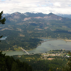
In my constant search for new adventures, I found an old, un-maintained trail in the gorge that looked very promising. Starting from the PCT just before the fork to Dry Creek Falls and connecting via Benson Plateau to the Ruckel Creek trail, Rudolph Spur looked very promising in every respect. So with a very strong group of hikers we decided to explore that area and navigate thru the woods to complete the loop. We started from the parking lot next to the Toll House in Bridge of the Gods where you can get on the PCT going south. The first part of the trail is not very pretty as it goes under the highway and then climbs to the power lines. After that, the trail gets a bit better as it traverses some nice forests until it reaches Dry Creek. Right before the intersection, we found a very faint foot path to the right which, according to the information I had, was the start of Rudolph Spur. Before heading that way though, we decided to continue a bit further to the bridge and take the short trail to Dry Creek Falls. I had visited this falls in the past and recalled them been very scenic. It did not disappoint. After a short break, we hiked back down to the fork and backtracked a bit to the faint foot path and turned there. Between the ground cover and low bushes I was able to make a faint path that was easy to follow but we were still unsure we were on the right place. After a couple hundred yards we found an old trail sign on tree. The sign doesn’t show anything anymore, but why would there be a sign if that was not the trail? The path continued uphill on a shallow canyon that isolated us from the highway noise and any views until we got to a knob that shows in the map as Manzanita. From there we got our first view of Table Mountain on the other side of the Columbia River. Then the hard part started. After traversing an open ridge, we turned west and followed the ridge up all the way to Benson Plateau. Most of this section was under a thick tree canopy with only a couple of clearings. Near the top of the ridge we found another view point with much better views of Table Mountain, Bridge of the Gods and Cascade Locks. On this rest, we took a short break for pictures (including a picture with all our backpacks that happened to be Osprey) before continuing on around the ridge to the top. Just a bit above 3000’ we found snow that became shin deep in no time. While being up front, I was able to make a very faint foot path that looked to be no more than a week or two old. Not trusting that entirely, I kept an eye on my GPS to make certain I was on the right track. While traversing the ridge, at some point we started to hear some voices. Obviously this was completely unexpected as we did not think anybody would be behind us. In the end we found that it was another group doing the Ruckel Ridge – Ruckel Creek loop. They were a bit off their track so when they saw us, they started following our tracks until we got to the Ruckel Creek trail. Once we made that turn, it was all downhill on a very steep, muddy and slippery slope. We stopped at several viewpoints along the trail that almost hang from the cliffs and offer some amazing angles of the river and Cascade Locks. When we finally got down to trail 400, we turned east to head back to the parking lot. This last section was completely uneventful and unattractive as it travels next to highway 84. Once there and having finished the loop, we did our mandatory stop at Charburger for a well deserved Burger and beer.
Interactive map
To see the full map, click Menu and select Full Screen. You can also click Terrain to change the map style
No comments:
Post a Comment