Coyote Wall, Nov 3rd

When you drive east on Hwy84 past Hood River, you can see a huge vertical basalt wall on the other side of the Columbia. That wall is known as Coyote Wall and frequented by mountain bikers. For us hikers, Coyote Wall offers a great destination to either check out the wildflowers in early spring, or to find a dry spot when it’s pouring rain in Portland. I’m not sure if there’s an official trail that defines the loop or not, but finding your way around it fairly easy. Since weather was not looking good and while we still wait for snow, Val and I decided to hit this trail for a change. It was a crisp day with consistent winds blowing from the west which made it a bit nippy but beautiful. Needles to say, we were welcomed with pretty amazing views of the western side of the Gorge and also of our trail ahead as grey clouds moved fast above us. Fearing the rain, we climbed at a steady pace enjoying the colors of the dried vegetation contrasting the dark grey of the sky. Up at the top, we found plenty of wind that prevented us from stopping for a snack so we continued and, instead of the longer loop, we took the connector trail that descends steeply into the valley to connect with the lower trail. We did lose some time on that connector as the leaves almost hid the trail from view but were rewarded with the sight of a deer resting in the woods under a ray of sun. Even though the deer left when we passed the first time, we saw it again, in the same spot, when we went back retracing our steps trying to find the way. It was a shorter hike than what we were expecting, still a great day out there


Interactive map

To see the full map, click Menu and select Full Screen. You can also click Terrain to change the map style

Khao Yai National Park, Sep 21st

When Val and I started planning our trip to Thailand, we thought of maybe doing some backpacking in one of the many national parks. After doing some extensive research, we found that it was not that easy. The only way to backpack in Thailand, it appears, has to be with a guide. Part of it has to do with the country’s fauna which includes elephants, tigers, wild dogs, monkeys and or sorts of insects and little creepy crawlers and another because well, there’s not a lot of information. With that in mind, we chose to go to Khao Yai National Park for a couple of days and do some hiking there since it was not too far from Bangkok. Getting there was part of the adventure as we ended up renting a car without realizing that we needed to drive on the right side of the car and the left side of the road. Add to that having to read directions and street signs in Thai, negotiate traffic with Tuc-tucs and pouring rain in the dark. Needless to say, we got to Khao Yai late in the evening after passing the hotel we stayed in about half a dozen times before we actually found it.
The following day, we woke up and headed to the park for some hiking. Our plan was to hit the visitor’s center first to get some info and maps and then pick up a trail and go. We ended up doing three short hikes in the park.

Kong Kaeo Trail

When we got to the visitors center parking lot, we noticed a hanging bridge over a river right behind the building. We walked to a sign a found out it was an actual trail. Since we still didn’t have any information or maps, we decided to go first to the visitor center. One thing we noticed in the parking lot though was almost everyone was wearing something that looked like a cotton sack over their lower legs. We asked in the visitor center about it and found that those were leech socks… and that we needed them to hike in the park. Luckily they had a little store in the visitor center where we were able to get a pair. Once equipped with the proper gear, we crossed the bridge and started our first official hike in Thailand. The trail was actually a paved path that meandered thru the forest. Certainly vegetation was completely different to what we’re use to here in the states. There were huge trees covering the forest and smaller ones with twisting branches and lianas and all sorts of small palms. About half way around the loop we found an actual trail with a little wooden sign that read Heaw Suwat Waterfall. WE took that trail and things got more interesting. With all the rain from the previous night, the trail was nothing but muddy. As we were walking we started noticing little black things climbing on our shoes and then on the leech socks. A close inspection revealed that yes; the leech socks were working – kind of. We continued for a bit up to appoint where the trail made a sharp turn and went steep down. Thinking about climbing back up and the leeches, we decided to turn around at that time. By then we couldn’t outrun the darn little things. As we hiked back to the paved trail we started hearing monkeys in the distance. I don’t know what was going on but they did have a very heated argument going on. At first it was cool, but after a while it was a bit scarier as we didn’t know how far or close they were.


Once back at the paved trail, we spent a couple of minutes flinging leeches of our socks and battling mosquitoes as the sounds of monkeys died away. As we hiked back, we passed another hanging bridge towards the end of the loop and found a sign pointing to the Gon Gheo waterfall. We followed the path as long as we could and then went back to the parking lot


Nong Phak Chi trail

After walking out of the Kong Kaeo, we washed our shoes and grabbed something to eat across from the visitor center. I won’t go into details but to this day we’re still not sure what we ate. Back at the car and after a bit of back and forth, we decided to drive to the Nong Phak Chi Wildlife Viewing tower parking lot and hike around there. We found that, if you take a tour, they drive you to the tower on a very bumpy dirt road. Since we were not in a tour, we just went around the gate and walked there. At first the trail passes some trees that block the views of some wide open grass fields. At first it looked like the grass was not that tall. Later we found that it was about shoulder high. From the road it was easy to see paths in the fields that we imagine are made by elephants when the go to a nearby salt lick. We got to the viewing tower and climbed up. Even though we didn’t get to see all the wildlife you’re suppose to see from there, that includes elephants, deer, wild dogs, boars, etc. It was pretty cool to get the vistas from that perspective. From up there, we noticed a trail going around the lake and continuing pass the salt lick in to the forest which we decided to explore. Once we left the tower behind, we got back on a muddy trail but without leeches this time. While going around the lake we got the most incredible butterfly display which made this hike worth. First it was a black and white butterfly with a couple of long appendages on the back that made it look like a little person. Then we saw a group on the ground that were black and green with some very vivid and even reflective green spots. These spots were more visible when they flew but even standing on a plant they were pretty impressive. Later we saw a simple black butterfly with very faint shades of blue/grey that made it look like its wings were made of velvet. And lastly, a white butterfly with lines and yellow marks resembling the color of a tiger
After that, we passed the salt lick and continued thru the tall grass fields towards the forest. As we did, the sky started turning grey menacing with showers. We pushed on and got into a very dense forest. We didn’t get all the sounds we got in Kong Kaeo but still it felt like a thousand little colored eyes were looking at us either in surprise or because we looked tasty. We continued for a while as it started to rain up to a point where we thought we were walking in circles. By then it had gotten pretty dark so we decided to turn around and retrace our steps back to the trailhead. As we did, rain subsided but the sky never cleared. Back at the parking lot we took a break and started questioning if we had enough time for another hike.


Haew Narok Waterfall
We got in the car and started driving almost aimlessly but thinking about something we’d been told in the visitor center. It seems that wildlife is more visible at dusk as it sometimes crosses the roads in the park. While driving around we saw a lonely monkey walking on the road. We stopped but didn’t open the windows or got out as we didn’t know how or if the monkey was dangerous. After a while, we continued slowly on the road and saw the rest of the group. There must have been a couple dozen monkeys frolicking around near the road. Then we saw a sign pointing to the Haew Narok Waterfall so we drove in and parked. At first it seemed desolated so we thought the trail was already closed but a ranger told us we had about half an hour and if we were fast, we could go to the waterfall. The part that she failed to tell us was that it’s very easy to get to the waterfall, the hard part coming back. The trail was a paved path thru the forest with some bridges crossing the river in several places. We continued until we saw the water disappear in a hole in the forest as it dropped a couple hundred feet. From that point on, the trail became a winding staircase all the way down to a viewpoint right in front of the waterfall. The waterfall was pretty impressive and reminded me of a waterfall I visited in Canaima, Venezuela when I was a kid. After enjoying the views, we started our way back climbing the winding
staircase. It was a pretty decent workout especially because of the humidity.


Map

Interactive map
All three hikes are in this map. To check an individual trail, click on the icon and follow the link

To see the full map, click Menu and select Full Screen. You can also click Terrain to change the map style

High Divide – Seven Lakes Basin backpack, Aug 30th

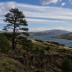
The High Divide and the Seven Lakes Basin is an area in the Olympic Peninsula that had been in my radar for quite a while. I remember reading reports from people that hike up there from the Hoh River trail and doing some research on my own about it. Most people describe this as being like the Enchantments only bigger. Getting there is always a challenge as you need permits, which are limited and hard to get, and you have to play with the weather a bit. The Olympic Peninsula gets rain pretty much all year long. With all that, I had it in the back burner but then Matt, a good friend of Val and I, invited us as he got permits for Labor Day weekend. So the plan was set and late Thursday night, Val and I took of to meet with the guys up at a campsite near Sol Duc.

Day 1 – Sol Duc to Lunch Lake:

We woke up bright and early to a somewhat cloudy day. We met with the Matt and the other guys coming on this four day adventure and soon after getting breakfast; we went to pick up permits and headed to the trailhead. The hike started on a trail that looked almost like a highway, and it remained like that until we got to the Soleduck waterfall.


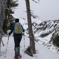
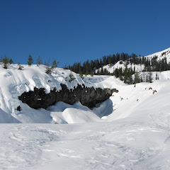
After a couple of pictures and getting our bearings right, we started climbing towards Deer Lake. The hike was pretty uneventful thru a lush forest until we got to the lake. I guess the only interesting thing was that the trail itself seemed very well maintained which we would learn later its pretty much how all the trails in this area are. We made a stop for lunch at Deer Lake and then continued climbing towards the High Divide trail. After a while, we made one last turn that finally gave us the first glimpse at the ridge and the trail going up on its side. Then, we got into the clouds. As we continued our views got limited to just about 100 feet in front of us. It was dense enough that we could barely make the trail, especially because it was a rocky section. Finally we got to our trail junction that would go over the pass and take us down to the Lakes Basin. After passing the ridge, we got somewhat views of Lunch Lake, our destination and Round Lake far below. And the switchbacks started. The descend was a bit grueling as we went thru a bunch of switchbacks on a trail that is made, yes, literally made of rocks. Every step up or down was literally like a staircase made with big boulders. Once down by the lake, we started looking for campsites. As a group, we had only one permit which meant that all of us need to set up in the same place. Being 6 of us with 5 tents made that a bit challenging but after going back and forth about 4 times, we finally picked up a large campsite on the northeast side of the lake. We had to do some mathematical calculations to figure out how we were going to set up so we could fit everything in that space – in the end; we were spending two nights there. After we figured that out and set up our tents, Val and I went for a walk towards Round Lake. Down there, we found a beautiful display of wild flowers, bumble bees and a deer that couldn’t have cared less about us being there.


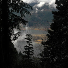
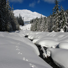
We didn’t go much further that day because we were a bit tired, cold and the weather was not playing nicely. Our timing couldn’t have been better. As we got back to lunch Lake the fog just came all the way down obscuring pretty much everything. I went for a walk around the lake to snap some pictures before heading back to camp and to bed.


Day 2 – Lunch Lake, Bogachiel Peak loop with side trip to Hoh Lake:

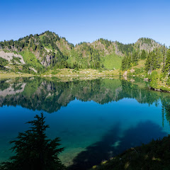
Then the most amazing thing happened. We woke up to the spectacularly clear day with just a couple of clouds in the sky. As Val and I always do, we got dressed quickly and went for a walk around the lake. I have to say that I have seen spectacular mornings while backpacking but this one is probably in the top of that long list


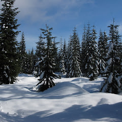
Once the drooling stopped, we went back to camp to have breakfast and warm up with the sun. Then we packed stuff for the day and shared our hiking plans for the day. This was the day to go out and explore the area in any direction you wanted. Val and I took off on a trail behind our campsite and took a detour to go check a little chasm I saw from the side of the lake. We hike all the way to the end where we found a little waterfall bringing snowmelt to the lake. It was beautiful yet not very impressive. I guess it looks way better in the spring when a lot more water is coming down. From there we got back on the ridge and followed the trail until it got to the upper basin where we found a small no-name lake that was the source of the small waterfall we saw down below. The surroundings where incredible with rocks and flowers everywhere. Since we had a pretty good plan for the day, we followed a straight line trail towards the High Divide which gave us really nice views almost every step we took. Once we reached the High Divide, we turned around and got a much better sense of the upper basin and all the little lake that dotted the area


From that point, we turn west and followed the trail towards Bogachiel Peak that ended up being a short adventure in itself. Close to the peak, we found a user trail that traversed a cliff with ample views of the upper basin. Yes, the views where really good, the route, not so much. At some point we had to call it and turn around to find our way back to the trail. Then, just several hundred feet down the trail we found an actual trail to Bogachiel so we headed up there… it was a bit disappointing. I guess we were expecting 360 degree views but that didn’t happen. So we took a picture of ourselves and headed back down. About a thousand feet from there, we got to the trail junction that could take us back to camp or go down to Hoh Lake. We stopped there to discuss as this was an optional side trip but since we heard that a couple saw marmots and bears down there, we decided to give it a try. The entire trail goes steeply down which made us think, every step we took, about the climb back. While going down we did stop once to reconsider but curiosity prevailed so we continued to the lake. That ended up being a good call for several reasons, one of them being that we needed more water. Just a bit before we got to the lake Val spotted a black dot on the other side of the lake moving…. a black bear. Shortly after we reached the lake and went to filter some water and there we spotted another bear on the other side of the lake. Yes, they did look like little black spots, very round and fluffy black spots. Berries were very abundant so bears didn’t have any interest in hikers


With full bottles of water, we then climbed back to the High Divide trail which, for some reason didn’t seem as hard or strenuous as we thought it would. From there we closed the loop going back to Lunch Lake in time to make dinner, enjoy the evening and go to sleep

Day 3 – Lunch Lake to Heart Lake:

The third day also started crisp and clear, not as the second, but still very clear. Our morning walk was very short as the plan was to have breakfast, pack and hike to Heart Lake. In the original plan, when we met with Matt to plan this trip out, he mentioned the idea of leaving the packs half way and doing Bogachiel peak this day, but since we had already done it, we voted for getting to Heart Lake and then exploring around. The hike started on the same trail we took the day before to the upper basin but before we started the park ranger encouraged us to explore of trail while minimizing our impact. So once we got to the upper basin, Val and I veered off and went around some of the little ponds we saw the day before. I couldn’t say is there were more ponds or we just saw some that we didn’t see the day before. Either way it was as spectacular as before with fields of green and spots of yellow around the crystalline blue of the ponds.


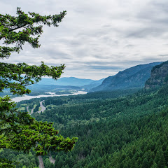
We continued up until we got to the High Divide trail but instead of turn right, we turned left towards Hear Lake. It was more uphill. The trail followed the ridgeline to the highest point on the trail where we got our first glimpse to what would be our next incredible view. From that knob, we descended thru several switchbacks where we made numerous stops to gram more blueberries. But then, we got to a saddle where another couple was taking a break and taking pictures. When we got there we learned why. The views towards Mount Olympus from that point are just breathtaking. Even though the mountain range is on the other side of the Hoh River valley, it almost feels like you can touch it. Yet you know it’s higher up and much colder as you see the hanging glaciers


We then continued down and veered of towards Heart Lake. The first section of the trail seemed that it was going to reach the edge of a cliff and then dropped from there but as we got closer to it, we noticed the valley opening up in front of us. Right at the edge before the trail start going down steeper you finally get a god view of Heart Lake which obviously is named after its shape


When we got there, we found that Matt had already staked out a spot for our tent high up on the side. We huffed and puffed with our packs until we got there, set up camp, had lunch and then went out to explore a bit. For that we just went back up to the High Divide trail and continued on it going east towards Cat Peak. After a while, the trail got pretty desolated and very brushy. It also started descending pretty quickly so we didn’t go that far as we didn’t have a lot of time left in the day and we were already a bit tired. When we got back to camp temperatures had dropped considerably and wind had picked up quite a bit as well. A Park Ranger had indicated that weather was turning and that we could get some rain. Then, as clear as the day was it got cloudy and then everything went dark and we went to bed


Day 4 – Heart Lake to Sol Duc:

Last day. The hike out day. We woke up to a cloudy, cold and almost rainy day. Considering we had to hike out and then drive home we woke up fast, had breakfast, packed our gear and got ready to go pretty quickly. Then we hit the trail going down. It was misty and cloudy all the way and soon we were back in the forest plowing thru mud in some sections. The hike was fast and uneventful as rain was pretty much chasing us but we were able to get to our cars just before it started.


You can check the pictures here

Interactive map

To see the full map, click Menu and select Full Screen. You can also click Terrain to change the map style

Pamelia Lake backpack, Aug 24th

Several friends had been visiting Pamelia Lake this year and posting amazing pictures in facebook. After looking for a while, it was clear we needed to add this to our to-do list. So one day, Val and I were sitting trying to plan an outing. We had several choices but decided to try our luck and see if we could get permits for Pamelia. Incredibly enough, we scored the last couple of permits for that weekend. Late on Friday we packed our gear and drove to the trailhead where we spent the first night in the car. It was something we wanted to try so we could have an early start without the rush of driving there. That turned out to be a great idea. On Saturday, we woke bright and early to a fabulous blue sky day. Soon after breakfast we hit the trail heading towards Pamelia Lake. That portion of the trail was interesting as we could see that the area get a fair amount of rain. Most of the trail is covered with dozens of little streams that crisscross the forest floor. Suddenly, we got to the lake. We were expecting a view like the one you get when you reach Coldwater Lake in Mt St Helens. Reality was a bit different. You can see the lake but not much of it. From there we veered off towards the PCT taking the long way towards Hunts Cove, our destination for the night. Once on the PCT, we were welcomed with some fantastic views of the area


From that point, the trail followed the side of the mountain with views of Hunts Creek and Pamelia Lake far below. Then we made a turn and found ourselves traversing a meadow with several small lakes, many of them without names, until we reached Mud Lake. Mud Lake is a medium shallow pond that’s named only in guides, not in maps, still it’s very easy to see why it’s named that way


We found a nice rock outcrop just above the lake where we stopped for lunch. From that point we got a clear view of what we originally thought was just a rock hill. Later, while studying the map, we realized we were looking at the west side of Mt Jefferson. We took our time to walk around and take pictures around the lake and while doing that, we found this little guy


After that, we continued towards Shale Lake. From the trail you can see it’s a very small lake but it has some pretty impressive views. We walked around to a campsite we saw from the distance and found the iconic, postcard like, view of this hike. From this vantage point you can see Shale Lake with the reflection of Mt Jefferson in the back. It was truly an inspiring view


Several pictures after, we continued on the PCT towards the Hunts Creek trail. This section of the trail was incredible as every turn offered a new view. On one side we could see our destination far below and on the other, a ridge line that almost invites you to climb Mt Jefferson. Towards the junction, we noticed a hill to the side where the soil had an intense red color. A bit later we noticed the connector trail we would be taking down to the lakes. Just as we did that, we saw the first clouds come from west and move quickly to cover the top of the mountain. By then we were a bit tired so we continued hiking down until we got to Hanks Lake. Once there we both got a bit indecisive. Usually we have a pretty good idea where we want to stay, but for some reason, that was not the case this time. We saw some viable and available campsites around Hanks Lake but notices they were pretty close to the trail. Since we wanted a bit more privacy, we decided to continue on to Hunts Lake. There we fund a campsite at the very end of the trail and another in the bushes. Not completely contempt with that, we went back to Hanks Lake and walked around. After a while both Val and I reached a point where we just needed to drop our bags, we were starving. Finally we made the call and went back to Hunts Lake, dropped our bags and cook dinner while setting up the tent. At dusk, the clouds were moving over the ridge and the sun was painting them orange. It was quite a sight that we enjoyed for a while before going to bed.


We went to bed and I started thinking about what to say or when to propose. Normally when Val and I go backpacking, we wake up early in the morning and before we have breakfast, we go out for a walk. I thought that would be a perfect opportunity for me to propose. Besides, it was our two year anniversary. Well, the plan was not realized. At some point during the night, it started raining so we woke up early as usual with the sound of ran drops over our tent. We took a peek outside and it was raining hard enough to keep us from going out. At that point I knew I had to change the plan, quick. So I turned around, picked up the ring I had in my camera bag, turned back around and managed to kneel in the tent. Grabbed Val’s hand and simply proposed. It was a magic moment for both of us. On one side she was not expecting it and new nothing about the ring and I wasn’t expecting her reaction. She did say yes.


After that magic moment, we managed to have breakfast in the tent and pack everything without getting stuff wet. It was nice we were not in a hurry as we had a short hike back out. At some point midmorning, we finally decided to get out packs on and hit the trail. Needless to say the hike back was full of laughter and kisses under the rain. Both Val and I got soaking wet but what can I say, I went out with a good friend and came back with a wife to be. How can you beat that?


Interactive map

To see the full map, click Menu and select Full Screen. You can also click Terrain to change the map style

Eden Park via Vista Ridge, Aug 10th

Can a hike be both beautiful and eerie at the same time? Yes, this one is. For this weekend Brian, Mark and Carol had planned to go backpacking. Unfortunately I wasn’t ready to do that as I was recovering from my thumb accident. Still, we though a day hike was something we could easily do. Knowing the route Mark and Brian where thinking of taking for the weekend, Val and I decided to hike in the same area with the hopes of bumping into them. The day was a bit gloomy but not bad to the point of keeping us away from the mountain so we headed out to the Vista Ridge trail. We didn’t realize beforehand that this trail borders the remnants of the Dollar Lake fire back in 2011. As we hiked up the Vista Ridge trail, we found a completely burned down forest that looked almost like an image taken from a Tim Burton’s movie. Seeing all the trees still standing up but completely burned was very eerie. Even with the amount of destruction, I couldn’t say it was ugly. The scenery was spectacular in its own way. As we gained elevation, we came out and went back into the fire boundary several times until we finally got a glimpse of Mt Hood. By then, the weather was turning grey. We continued until we found the junction with the Timberline trail and turned west towards Cairn Basin. From this point on, we completely left the fire area and entered a lush green meadow full of wildflowers and beauty. It almost seemed that we had been teletransported to another place. Closer to the shelter we found even more burned out sections but not as big as the ones on Vista Ridge. We got to the shelter and decided to stop for lunch just behind it where the flowers and views of the mountain were pretty incredible. Luck was not with me at that point as I opted for waiting until had finished my sandwich to take a picture. By then, the mountain was completely gone behind the clouds. We waited a bit to see if they would move but that didn’t happen so after a while we just took off towards Eden Park. It was pretty much downhill from that point on with more than a couple of stream crossings. We saw probably two more hikers but no sign of Mark and Brian. Finally we looped back to the Vista Ridge trail and hiked back to the car. The eerie part of this hike did not finished there though. Just coming out of Lolo Pass road, we decided to stop and get something to eat at Sky Wax. While there, weather turned bad incredibly quickly going from grey to stormy to lighting and hail. Back in the car and driving home we got an emergency message on the radio calling everyone to evacuate the area as there was a huge storm coming that way. We feared for Mark and Brian as we thought they were up in the area we hiked. Luckily we learned that they found out about the bad weather at the last minute and decided to change their plans and go somewhere else. They were ok although still got part of the downpour and had to cut the weekend short.


Interactive map

To see the full map, click Menu and select Full Screen. You can also click Terrain to change the map style

Grassy Knoll and Big Huckleberry Mountain, Jul 13th

Located in the Gifford Pinchot National Forest on the Washington side of the Columbia Gorge, Grassy Knoll is one of those hikes that are seldom overlooked. Getting there is part of the fun, in fact, the first time I went there; I thought I was in the right place only to find later I was a mile away from the actual trailhead. This time, knowing that good piece of information I was able to get the group to the trailhead without getting lost. Once on the trail you don’t have to wait long for the views. Soon after starting, the trail reaches the ridgeline traveling north. To the east the views are outstanding and even eerie as you see a big plain, all green, all covered in trees. It almost seems out of place to have an extension of land almost flat in the idle of the cascades. Looking at a map you realize that big expansion is the big lava bed, an ancient lava flow that leveled everything in its path. On the other side, far in the Distance, beautiful Mt Adams stands there looking at you. Not long after starting the trail makes a turn and you get some views towards the south that include Mt Hood and the Columbia River basin. And then, you get to the first destination, grassy Knoll. This flat area is where the old fire lookout tower used to be. You can still see some remnant of the tower as you enjoy the views around. From there, after a short break, we continued north towards Big Huckleberry, our second destination. The trail is not much different as it continues meandering thru the ridge until it gets to a point where a sharp turn right takes you to the summit. This summit is a bit less inspiring than Grassy Knoll as views are a bit limited. Still, it offers several spots where you can drop your pack and enjoy a nice lunch in the company of your hiking buddies.


Interactive map

To see the full map, click Menu and select Full Screen. You can also click Terrain to change the map style

Silver Star: Grouse Vista – Sturgeon Rock loop, Jun 30th

I have to say that Silver Star is still one of my favorite hikes near the Gorge. Not only any approach you take is challenging and beautiful but it’s also a very rewarding hike. From the summit the views expand 360 degrees and can include several peaks in the cascades. This time Val and I lucked out with a perfect day and vistas extending all the way to Mt Rainier on the north and Jefferson to the South. The hike from Grouse Vista is one I’ve done several times before as it’s the closest to drive to. The first part though just traverses thru forested areas but soon, after you pass the Pyramid Rock everything opens up. I recall last time I was in the area on a very cold winter day that ended up obscuring everything. Even like that it was beautiful. This time though, we had a marvelous display of wildflowers all the way with clear views of the summit and Sturgeon Rock. We made it first to the summit and visited the north side for just a minute to take a picture or two. Since there was a big group resting there, we went to the South side of the summit to enjoy a more peaceful lunch with open views towards Mt Hood. On our way back instead of doing the longer ridge trail and descending to the Tarbell trail, we did the shorter Sturgeon Rock trail instead. On the way down, we found a foot path leading up to the rock so we veered of trail and went up to check it out. The views from up there are something I’d never seen before. Been able to see the south side of the summit, at almost eye level was pretty interesting. Also, the view south that glimpsed over the Gorge toward Mt Hood was also very interesting. From there we continued on the trail towards the Tarbell trail and then closed the loop returning to the car. Needless to say it was a marvelous hike in the company of my sweetheart


Interactive map

To see the full map, click Menu and select Full Screen. You can also click Terrain to change the map style

Puppy Dog Mountain, Jun 9th

This is what happens when you’re just lazy. You go out to do a known hike, a trail that you could do with your eyes closed and then, half way up you decide to turn around and go back down…. So instead of doing Dog Mountain, probably the best known hike in the Columbia Gorge next to Angel’s rest, we did Puppy Dog which is the exact same trail but just to the first view point where the trail turns back on a switchback and climbs to the top of Dog. We did the hike with Ramon, Lisa and Marcel who proved to be a great hiker and very nice company. It was a beautiful day with splendid views of the Gorge and plenty of wildflowers blooming all around.


Interactive map

To see the full map, click Menu and select Full Screen. You can also click Terrain to change the map style

Rock of Ages, Jun 1st

Val and I wanted to go for a good, close by hike with good distance and elevation. Looking at different possibilities, we picked Rock of Ages since none of us had done it in a while. So we went along with Mark and Carole with the intention to do the normal loop. We got there pretty early and where on the trail real quick. Without a lot of complications, we found out way to the arch where we made a quick stop to catch our breaths and take some pictures. Then we started the real climb. We followed the devil’s backbone up all the way to Benson Plateau which went without a hitch. To this point, we were on track for timing so we stopped at the junction of Rock of Ages and the Horsetail Creek trail. The idea was to take this trail and then descend towards triple falls but that’s where things didn’t go as planned. By mistake, instead of continuing on the Horsetail Creek trail, I turned on the Bell Creek trail thinking it would go straight to the bridge and then down… Big mistake. The Bell Creek trail took us for a spin thru the forest with lots of ups and downs and beautiful scenery but clearly way out of our way. At last, we found the junction with the Oneonta trail which we knew would eventually join back with the Horsetail Creek trail. We took that path down which seemed endless. Several switchbacks and miles later, we were back on track descending towards Triple Falls. By then it was later than expected so we didn’t make the accustomed stop to check out the waterfalls. Instead, we rushed down to the car completing a bit over 14 miles.


Interactive map

To see the full map, click Menu and select Full Screen. You can also click Terrain to change the map style

Bald Butte, May 11th

Not to be confused with Bald Mountain, which is also located in Mt Hood but on the north west side, Bald Butte is one of the high points on a small ridge on the east side of the Hood river basin. I didn’t know anything about the existence of this trail until I went to a presentation about a new hiking book at the Mazama Climbing Center. In that presentation I learned about this usually missed hike which, according to the author, can challenge Dog Mountain when it comes to wildflowers with the advantage of very little or no people. That by itself was reason enough for me to go explore the area. Getting to the trail is fairly easy and even though it has very few parking spots, it’s not much of a concern as not too many people go there. The trail starts going thru some heavy bush but quickly gets to an open spot that gives you a taste of what’s to come. From the trail you can clearly see Parkdale, the upper Hood River Valley and obviously the northeaster side of Mt Hood. The view at this point is pretty spectacular. Continuing up, the trail leaves the heavy and uninteresting bushes and becomes a more open trail with wildflowers and low bushes. Most of the trail faces south but every so often it will pass the ridge to the other side where Bald Butte becomes clearly visible. Once you think you’re done huffing and puffing, you get to a T junction with the Surveyor Ridge trail. As planned, we turned left here and headed towards Bald Butte. About half way there, we came to an opening where an access road reaches the ridge. We learned that this entry point is normally used by mountain bikers and motocross bikers to access the same trail. Also, from this point, the trail becomes a service road that reaches the power line. From the distance you start hearing the buzzing of the electrical lines which only grows louder as you get closer. Right under the towers, there’s a small open area that looks like a parking lot with very nice view of the valley and Hood. From that point, the trail goes up again and leaves the power lines behind. Towards the end, the trail comes to an opening with probably the best view. As you look up towards your destination, you see the road, and a field covered in yellow wildflowers resembling those manicured background pictures we have on our computers. The trail doesn’t end at the summit of Bald Butte but this is a very good destination for views. From what we could see, you can continue forward dropping sharply to regain elevation at the other side. After a nice lunch with a view, we headed back and once we got to the T junction, we decided to explore the other side for a bit. For the most part it was not very interesting as the trail was navigating thru a dense forested area. Once we reached a butte with no name, we noticed a user trail towards the west to what seemed to be another view point. We followed that path and got to a small open area with some rock formations and steep drops. Views from this point where just as good as those from the trail. We took a second short break and then headed back down the way we came.


Interactive map

To see the full map, click Menu and select Full Screen. You can also click Terrain to change the map style

North Lake via Wyeth Ridge, Apr 27th

Somewhere in the back of my mind I had the idea that I had done the Wyeth trail before. For some reason, that recollection also told me that it wasn’t a very interesting trail. I did remember that it was not easy. Well, I found out I was wrong in all counts except for the difficult part. I certainly recall doing part of this trail but at that time we didn’t reach the lake or any of the amazing viewpoints on the way. This time, with more time and stronger hikers, we did the entire out and back route North Lake and were surprised, not only by the destination, but also by the route. The first part is as any other Gorge trail; you climb quickly to the power lines, cross under them and then, start heading up. For a while, the trail doesn’t offer any views, it’s just a very forested path with tall trees that mask the sounds of the highway only enough to give you an idea you’re out there. After some huffing a puffing and several switchbacks, some views start appearing thru the trees. The first one was a clear sight of Mount Saint Helens on the other side of the river. Higher up, the trail gets to the ridge and skirts on the western side with open slopes overlooking the Columbia River and the Harphan Creek drainage. As if this is not interesting enough, wildflowers in this area are just magnificent at the right time. On our hike we saw a large variety that included wild orchids and lilies. Then, it was back to the hard, steep climb thru the forest. At some point we hit snow and following the track became a bit more difficult. For a moment we veered too much to the east and ended walking on slushy snow over Lindsey Creek which, according to the route I had was my limit. Once I realized that, I shifted direction going straight for the lake. Getting there was one of those wow moments where you see there’s a viewpoint, you know the views are fantastic but you don’t see them until you’re standing right there. When we got there, the sun was hitting that side of the lake so there was no snow making it a perfect spot for lunch and well deserved rest. I did take my time taking extra pictures of the lake while the rest enjoyed sunbathing on the rocks. Our return was following the path all the way down to the car which was as enjoyable as going up… minus the huffing a puffing of course.


Interactive map

To see the full map, click Menu and select Full Screen. You can also click Terrain to change the map style

Rudolph Spur from Herman Creek, Apr 20th

I must say that this is one of those routes I do love doing, even when I get a bit disoriented, loose the trail and have to find my way around. And yes, despite the fact that I have done this trail several times, every now and then I manage to go in the wrong direction. This time though, instead of starting from the Bridge of the Gods parking lot and hiking up towards Dry Creek Falls, I decided to start from Herman Creek. The only reason for that was to add a couple extra miles to the loop and some trail I had not done before. Leaving from the Herman Creek campground, the first part of the hike just follows the same route for Herman Creek but soon after passing the power lines, a trail sign shows the path of a shortcut towards the PCT. That path meanders thru the forest for a bit on an area that, even though is pretty close to the highway, is very secluded. We found several smaller streams with hidden waterfalls on this route that looked pretty nice. Then, after a bit over 3 miles, we reached the bridge over Dry Creek. We took a short break at this point and considering we had a long way to go, we opted for not doing the side trip to Dry Creek falls. Then we left the trail behind and started following the very faint path up Rudolph spur. Weather was not cooperating much so we did navigate a bit in the fog and at some point I made a wrong turn that thru us way off the path. After realizing my mistake and making corrections, we managed to bushwhack our way back to the faint trail and finally reach a viewpoint with open vistas of the Bridge of the Gods. To our surprise, we found a large group of oriental people resting and having a bite to eat at that spot. While taking our break, we learned they took the route we did and got there before we did which, to an extent doesn’t mean much until you consider how young they were. One woman we talked to was over 70 years old! And the youngest was easily over 50. If that wasn’t impressive enough, after taking some pictures, they continued up towards Benson Plateau and disappeared in the mist in almost no time! Obviously any comments of being tired vanished from our thoughts at that point. Then we continued up towards the Plateau where we found some snow and a very foggy forest. At a point, I got the feeling I was again going in the wrong direction and to our surprise, and rescue, we crossed path with the same group again… all happy and having the best of times and no sign of being tired. After exchanging some direction we finally made it to our trail and continued our loop towards the PCT. Finally, once we had lost some elevation it all became much easier and we were able to enjoy some scenery as we completed the loop going back to Herman Creek. If anything, we learned on this trip not to complain about our age!


Interactive map

To see the full map, click Menu and select Full Screen. You can also click Terrain to change the map style

Indian Point, Apr 14th

Indian point is one of the many destinations in one of the many trails near Herman Creek. It is a prominent rock that opens up to the gorge inviting you to do things you shouldn’t do… or, you should know how to do. If you look at pictures of this feature (I was not able to take pictures myself because it wasn’t clear enough) you’ll see it’s a rock formation that seems easy to climb onto. Problem is that it’s completely exposed and usually very windy. Falling from there would not be nice. Still, it offers several ways to hike in the area. Certainly you can go straight to it and then retrace back or, you can take any of the trails in the area and do a loop. Val and I decided to do a loop and keep it low to avoid going thru a lot of snow. So we started from the Herman campground reaching quickly the power lines. From there, we continued up to a big junction where the Gorton Creek trail and Nick Eaton Creek trail meet. The Gorton creek trail goes directly to Indian Point and then continues climbing on the ridge. The other way climbs steadily towards Nick Eaton and then pretty much shoots straight up on a series of switchbacks. On this trail, there are several connector trails that will take you to Gorton Creek trail. We took one of those and quickly entered the snow. For just a bit we lost our bearings and noticed we were going the wrong way. A quick correction and we got back on track and started descending on the other side on lingering snow. Finally we got out of the snow roughly at the switchback where a user trails leads to what looks like a vertical drop-off. On clear days (and good conditions), you can follow this trail to Indian Point and maybe climb the rock. So far it’s been three times I’ve been in the area and still haven’t seen it… I guess one of these days I’ll get the opportunity


Interactive map

To see the full map, click Menu and select Full Screen. You can also click Terrain to change the map style

Hamilton Mountain, Mar 31st

After a short period of being inactive as I was out of the country for work, Val and I decided to do Hamilton Mountain as it provides pretty much everything you would want from a hike. It has good views, descent elevation gain and distance and is close to town. Even better, we scored with one of those crisp/clear early spring days. Also, since we were on our own, we took our time to get there and start without being rushed. We started climbing swiftly at first with few views of the Gorge but knowing what was to come. Shortly after we took the detour to Rodney falls and checked the Wind Tunnel. As always, I started thinking on ways I could get a picture from that viewpoint, but there’s so much water and mist coming out of the tunnel that it would be almost impossible unless you had an underwater camera case. From there, we continued and took the “hardest” route that follows the ridgeline with clear views of the Gorge as it goes thru numerous switchbacks. At about two thirds of the total elevation, we took a little detour to an incredible viewpoint on top of the Gorge. I’m not sure what’s the name of it although in maps it’s shown as “Climb”. Either way, getting there only requires a bit of a bushwhack but is very well worth the effort. We took a short lunch break at that point enjoying the views and the sun before continuing up. Then it was all the way to the vey uneventful Hamilton Summit. Since we wanted to do the loop, we continued on the ridge heading south to the old forest road and then down the “less difficult” trail. This trail has always surprised me as it seems to be kind of an afterthought or a back way to somewhere. It certainly doesn’t offer many views although it’s gentler on the knees which we both needed after not being too active.


Interactive map

To see the full map, click Menu and select Full Screen. You can also click Terrain to change the map style

Newton Creek, Mar 2nd

Ah Newton Creek, the infamous Newton Creek that hasn’t allowed me to do a loop that I’ve been wanting to do in the winter for as long as two years now? Anyway, this is not yet another attempt at that loop. It’s another loop in the area that I did long time ago that is also very nice and includes some backcountry navigation. The route is pretty much the same as before heading towards Newton Creek but then, instead of crossing it, we followed a path uphill on the west side of the creek. This path meanders thru the forest with several openings offering clear views of Mt Hood (although it was hiding from us on this particular day). We followed this path to a point where you either veer of a bit and climb on a ridge or get deeper towards the Newton Creek canyon. Since I didn’t want to cross Newton, we opted for the first choice. And I have to say that is if probably the second best part of this loop. There’s no actual route but you are following the spine of a ridge with deep valleys on both sides. To your right is Newton Creek and to your left is Clark Creek. This ridge tops of at some point where you leave the forest behind and are welcomed by great vistas. Trying to avoid crossing a creek, we continued up until we found a covered spot over Clark Creek to cross and then do the hard climb up towards a parallel ridge on the west slope. From there you can see some of the lift lines in Mt Hood Meadows and several ski tracks left behind by some valiant backcountry skiers… or just lost skiers. Then came the best part of this route, going down on a ridgeline with clear views to the south that, on clear days, includes Mt Jefferson and Three Sister. Eventually the trail crosses the Newton Cree trail which you can’t miss if you are going down. Despite the fact that we didn’t get to enjoy a clear blue sky day, we certainly enjoyed the workout, the views and the route


Interactive map

To see the full map, click Menu and select Full Screen. You can also click Terrain to change the map style

Nesmith Point, Feb 16th

So the weather was not looking very good for the weekend but we still needed to get out and do some distance and elevation. After considering several possible choices, Val and I picked up Nesmith Point in the Gorge. Nesmith is one of those trails that goes constantly up following a mostly forested path. Along the trail there are a handful of viewpoints that open towards the Gorge but as you’ll see in the pictures, we were already at cloud level so visibility was almost zero. Still, it was a good day to get out in the company of some old friends. We didn’t get wet but we did get a bit cold up there.


Interactive map

To see the full map, click Menu and select Full Screen. You can also click Terrain to change the map style

Worm Flows, Feb 10th

If I tell you that this route also starts from the Marble Mountain Sno-Park, you’ll start thinking that this is my new favorite place to go snowshoeing. You may actually be right or at least, it’s nice to explore a new area for a change right. So having done Chocolate falls and June Lake, the remaining loop I had to try was the Worm Flows. Originally I wanted to combine this with June Lake but I haven’t found yet a way to connect the two. This loop is a bit east of the June Lake trail and traverses an area that was pretty much created by flowing lava. I haven’t been here in the summer but supposedly, the entire hill is a lava flow that formed the wall where the water fall to June Lake comes from. Being a nice, warm day, Val and I decided to try it out by ourselves. Also, after navigating and leading some hikes, I needed a rest so I even left the GPS at home and navigated the old way… with map and compass. Is not that this area is too difficult, but you just need to make sure you’re turning where you need to. The first part was the usual forest walk heading towards the June Lake trailhead but at that point, instead of turning left, we continued straight. Soon we reached a stream big enough not to be covered in snow but narrow enough for us to jump to the other side. This was actually fortunate as we did not see any tracks after the creek leaving the entire area to ourselves. I can almost say it was a bit disappointing that most of the loop traverses new forests with limited views of St Helens or the surroundings. There are not many signs that you are walking over a lava bed. That said, we had solitude, incredibly nice weather and a lovely day.

Barlow Butte, Feb 3rd

This is definitely one of my favorite’s places to go snowshoeing. You might remember that I tried this route clockwise several times without being able to find a way to come down Barlow Butte. Finally, about a year ago (or more) I tried the loop but going counterclockwise on a low snow day. That day we were able to find a route and complete that elusive circuit I wanted to do. Better yet, I was able to map it so I could do it again. This time that was my intention but weather was not cooperating much. The day was gray and cold and dark. Yet we were able to find our way to the butte albeit not the normal way. At some point we veered farther north than intended to so we ended up going straight up on the north face of the frozen ridge. It was a bit exhilarating as the slopes were completely frozen. It made the whole thing feel like a true mountaineering experience. The weirdest thing was that the slope was not a big sheet of ice but rather a slope covered with small ice pellets. At points it felt as we were going up a scree slope. Once we reached the Butte, we were able to find our way, the normal way, and continue on to the south side. Incredibly enough, that side looked much better as we could see clearly all the way to Jefferson under a cloud ceiling. The rest of the loop continued as usual navigating on the ridge and then finding our way down to the Barlow Ridge road.


Interactive map

To see the full map, click Menu and select Full Screen. You can also click Terrain to change the map style

Chocolate Falls, Jan 19th

After doing June Lake, I realized there are a lot of trails and routes that start from the Marble Mountain Sno-Park. One of those is Chocolate Falls which I had read about before. As a hike it didn’t interest me that much because it was not very long and by the description, perhaps not that impressive either. The name comes from the fact thatthis is a small creek that comes from the top of Saint Helens picking up minerals and dirt. Once it reaches the rock wall, the water looks brown like chocolate. The part that hadn’t occurred to me, was this route could be done in winter. So I got there, started my slow ascend towards the waterfall and soon realized that this trail is also the winter climbing route to Saint Helens. Yes, there were a lot of people heading up. I also saw a couple of big groups doing some rescue training which was cool. What wasn’t very cool (and I didn’t know) is that it seems that the creek freezes in winter so the waterfall is dry. Still the route offered some really nice views of Saint Helens and the south cascades. Training to make the route a bit more interesting, I did a bit of backcountry going over the moguls on the lava field. It was quite eerie as you saw rocks and little crevices and cracks in the snow. It was a bit of a guessing game trying to find a safe route thru that stuff. Once on the other side, I continued to June Lake for a bit to complete the loop.


Interactive map

To see the full map, click Menu and select Full Screen. You can also click Terrain to change the map style

June Lake, Jan 12th

About three or four years ago I joined, just for a brief period of time, a photography group with the intention of learning some tricks and improving my photography skills (which I’ve gotten by simple trial and error). I went to several events with that group including a snowshoe to June Lake. That’s when I learned about this little lake tucked away in Mt St Helens. I know I had read about it before as being a short hike and a long drive which is why I hadn’t done it. With the photography group I learned that in winter, part of the access road is closed so you have to snowshoe in from Marble Mountain. This adds some distance making it more appealing. Wanting to try something different, I decided to do June Lake and maybe extend with some explorations going over the worm flows. What ended up happening was a bit more interesting. With a small group of friends we headed there and started from Marble Mountain following a trail that parallels FR83. That part of the hike is not very interesting, especially due to the noise of the snowmobiles that fly by on that road. I remembered from my first time that, at some point, we needed to cross a creek to get on the trail to the lake, but before we got to that point, we found a fork in our path. It looked like the path to our left was more direct so we took it. That led us straight to the creek, not to the bridge. At that point I checked the map and it looked like we could backcountry from that point on to the lake so we started meandering next to the creek. It was a really nice time as we plowed thru new snow on an area where there’s no trail. As we got higher, some challenges started presenting in the form of steep slopes going straight to the water. Although some of us had the right gear and experience to continue, we finally got to a point where we had to turn around. Yes, there was a bit of frustration as that was cutting the possibility of going around the Worm Flows but we managed to get back on the road fairly quick, cross the bridge and get on the actual June Lake trail. He trail was very well marked and pressed that you could have actually made it without snowshoes. Finally we got to June Lake just when the weather was starting to change and the sky was turning grey. We stopped there for a quick bite while we enjoyed the waterfall and the many ice teeth it had. In the end, even though we didn’t do the loop I had in mind, we had a fantastic day breaking trail in new snow.


Interactive map

To see the full map, click Menu and select Full Screen. You can also click Terrain to change the map style

Angel’s rest, Jan 1st

Happy New Year! --- Wow, it took me almost four months to get here. Sorry, I’ve been incredibly busy lately and haven’t got time to continue my journal. But here I am, again, this time with a very short post. Not because I don’t have much to say but Angel’s Rest is probably the best known hike in the Gorge. Don’t believe me? Just sit in the parking lot for a couple of hours and you’ll see the parade of hikers coming in and out of the trailhead. One word to clarify here, I’m calling them hikers although not all of them are. Being one of the most accessible hikes in the Gorge we, real hikers (I’m not trying to insult anybody here) often see people that really shouldn’t be hiking here. This day was no exception. January first is still the middle of the winter so you’d expect it to be cold, maybe rainy and/or windy. It was very windy and cold. Still Val and I saw at least a dozen “hikers” wearing sneakers and jeans going up to Angel’s rest. In one of the pictures you’ll notice that the trail is frozen. Although the picture doesn’t give it credit, there were parts were it was just dangerously frozen, to the point that we saw everyone in a group coming down, fall on the same spot. It seems that Val and I were the only ones there with traction devices (thank you micro spikes – best ever) and from the few with trekking poles. Anyway, it was a short hike that we did in a handful of hours just to burn a bit of what we ate the night before. It was a very windy day to the point that we were not able to reach the actual viewpoint in fear of flying of the mountain. Beautiful day and great way to start the year…. Oh, and those pictures were taken with my new camera (I’m still in the process of re-learning with this one)


Interactive map

To see the full map, click Menu and select Full Screen. You can also click Terrain to change the map style

Ghost Ridge, Dec 29th

Most of the time, when we go snowshoeing, we get anywhere from some cloud cover and limited views to full grey skies with no views. On those days, we have to conform with trees, valley, creeks and the multitude of shapes that the snow makes. But every now and then we get a perfect blue sky day, that even with some patchy clouds here and there, makes the whole experience a complete different thing. This was one of those days. Certainly Ghost Ridge is a route I’ve done multiple times. Sometimes mixing it with Palmateer point and Devil’s Half Acre. This time the idea was to visit Palmateer Point as well but that spectacular weather didn’t last long and my route finding skills were a bit off. So even though the actual route as pointed is about 5 miles, we ended up doing almost 7. Nevertheless we got a real treat. Not only he snow was that perfect fluffy, soft white stuff that you sink in with every step but the views of the mountain and snow covered trees was outstanding. I’ll let the pictures do the talking now


Interactive map

To see the full map, click Menu and select Full Screen. You can also click Terrain to change the map style

Barlow Ridge, Dec 22nd

Barlow Ridge is one of my, at least once a year snowshoe route. It follows the same way as the mineral Jane but once you get to the T junction with the Barlow Road, you turn right instead of left. Then it’s pretty much a choice on how far you want to go. Sometimes I get to a point where I veer off and climb towards Barlow Butte but this time we decided to keep it simple and just enjoy the day. The day started a bit cloudy but very soon it cleared up and we had a fantastic, clear blue sky day with excellent powdery snow. About half way up we found the end of the tracks from whoever went before us so from that point on we were breaking new trail. As we went, we took turns to be up front doing the hard work while the rest followed. We continued like that for a while until we found a sunny spot ideal for lunch and return point. Around us the scenery was incredible. The heavy snow was pushing the smaller trees down which, on the side of the hill, looked like a little army of tired monsters. After enjoying the scenery for a while and just before it got really cold, we started our way back the same way to the car.


Interactive map

To see the full map, click Menu and select Full Screen. You can also click Terrain to change the map style

Mineral Jane, Dec 8th

So what else can you do from Barlow Pass? Well, you can definitely try Mineral Jane. I did this once before trying to reach White River which we never did. After hours plowing thru the snow, we finally got tired, turned left and got back on hwy35 to walk back to the car. That obviously left me wanting to explore more. Looking at maps, there are a couple of trails in the area which are not marked for winter navigation. Trying to follow any of these is a bit of a challenge. On top of that, there’s water. Once you get to the meadow area, there are several creeks that flow south. To this day, I haven’t found bridges or an “easy” way to cross. The couple of times I’ve been in the area, we’ve opted for the biggest log and just crossing on top of it. Certainly this is no easy task. On one side you have the freezing running water bellow which you certainly want to avoid and then, you have the snow/ice accumulated on the log that makes crossing with snowshoes a bit tricky. With all that we still decided to go and try it again. It was a beautiful day in its own way. Yes, the pictures don’t show blue skies or even sun, still the scenery was beautiful with a million shades of grey. We did have a couple of extra challenges as there wasn’t enough snow to bend and cover all the vines. Although it sounds as improbable, we were bushwhacking in the snow


Interactive map

To see the full map, click Menu and select Full Screen. You can also click Terrain to change the map style

Saddle Mountain, Dec 2nd

All things come full circle at some point I guess. Besides being the first hike I ever did here in Oregon, This is a hike that I have done numerous times and still waiting for that perfect weather conditions that will allow me to see the coast. Certainly this winter day was not the day for it. It was actually a last minute decision between Val and me to just grab our gear and go out on a close by hike. At first it looked promising as we were able to see the top from the parking lot illuminated by sun. That, unfortunately didn’t last very long. Soon after we started, we got a bit of rain and very low hanging clouds. As we gained elevation, it almost seemed like we were scratching the underside of the clouds and trying to climb over them. Most of the trail was filled with running water from the top. As soon as we got in the open wind started blowing and conditions turned for the worse. Val was plowing the trail going up but by then I got very cold and we had to turn around defeated by Saddle Mountain


Interactive map

To see the full map, click Menu and select Full Screen. You can also click Terrain to change the map style

White River, Nov 22nd

Early in the season, when the snow starts to fall, white river is one of the first places to get fully covered in the white stuff. Late in the fall or very early in the winter, this place is great to break down the snowshoes after a long period of being hanged on the wall (or any other place they might be stored during the summer months). It’s even better if you get lucky enough to get there before everyone else so you get the mountain to yourself and no tracks to follow. Contrary to a lot of other places, White River is a big open area that invites to explore and follow pretty much any route you want as the river serves as a guide of where you are. From the multiple times I’ve snowshoes there, I’ve picked to routes that I like as the cover the easy yet very scenic part but also add some good elevation gain and even better views from high ridges. One of those routes is to the west reaching Boy Scout Ridge from where you can navigate back down or continue towards Timberline. The other option, sometimes a bit more adventurous, is to climb a ridge on the other side of the river. The “more adventurous” part comes from the fact that you have to find a good spot to cross white river which, in many cases, is not that easy. In any case, either way you go, if weather cooperates a bit, you can be sure you’ll get splendid views and a descent start of the snowshoeing season


Interactive map

To see the full map, click Menu and select Full Screen. You can also click Terrain to change the map style

McNeil Point, Nov 10th

When you look on almost any guide for a flower hike, you’ll find McNeil Point near the top of the list. Certainly you have to wait a bit to go there as flowers tend to bloom more towards the summer when it gets warm enough. On those days, this hike is simply spectacular. During the colder months though, doing this hike can be a bit of a challenge. Part of it is getting to the trailhead (as we proved this time) and another is being able to hike the trail. I wanted to see this trail with some snow so I decided to go after one of the first snows we got this season. As I mentioned, getting there was a bit of a challenge. The road was already snowed with a thin layer of ice. Everything was cool while we kept moving but at some point I had to stop and that was it. The car started to slide by itself so we had to control as we could until it actually stopped. All that sounds easy until you picture the steep ravine to the side. Once we stopped, it was time for chains. I have to say chains are great despite the pain to put the on. Then, we finally made it to Top Spur, geared up and started hiking. As you’ll see in the map, there are a couple of ways you can do this hike. I opted for doing the trail around Bald Mountain first as the day was clear and we didn’t know how it would be later. After the quick ascend thru the forest we came to the open path overlooking the Muddy Fork. As expected the views were fantastic with Mt hood wearing a white hat. After circling Bald Mountain, we took the shortcut to get back on the McNeil trail and started climbing steadily. This trail passes an open side hill that on clear days also offers splendid views and flowers (in season) but the weather had completely turned on us so when we got there, it was pretty much a white out. It almost seemed like a complete different day than what it looked like when we started. We pushed on and further up we found the direct path that follows the ridge line straight to the shelter. We took this trail and continued on a mantle of grey that enhanced some of the features you find on the trail. Finally we made it to the shelter for a well deserved lunch and possibly the best timing ever. As we got our lunch out of our packs, the clouds parted to give us an incredible sight of Mt Hood and our surroundings. Looking towards the Muddy Fork we could see the cloud being held in place by an up current like a gigantic wave. At that point wind started blowing so we got cold pretty quick indicating it was time to move. We continued our hike on the trail towards Cathedral Ridge and then connected with the McNeil Point trail to hike back down. As we did, the clouds started moving in quite fast menacing with another white out that never came. Certainly this is one of the cool things about hiking in Oregon. You can do a trail many times but if you just wait until the season change, is like getting a brand new route


Interactive map

To see the full map, click Menu and select Full Screen. You can also click Terrain to change the map style