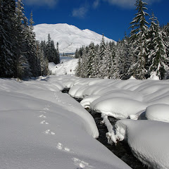
About three or four years ago I joined, just for a brief period of time, a photography group with the intention of learning some tricks and improving my photography skills (which I’ve gotten by simple trial and error). I went to several events with that group including a snowshoe to June Lake. That’s when I learned about this little lake tucked away in Mt St Helens. I know I had read about it before as being a short hike and a long drive which is why I hadn’t done it. With the photography group I learned that in winter, part of the access road is closed so you have to snowshoe in from Marble Mountain. This adds some distance making it more appealing. Wanting to try something different, I decided to do June Lake and maybe extend with some explorations going over the worm flows. What ended up happening was a bit more interesting. With a small group of friends we headed there and started from Marble Mountain following a trail that parallels FR83. That part of the hike is not very interesting, especially due to the noise of the snowmobiles that fly by on that road. I remembered from my first time that, at some point, we needed to cross a creek to get on the trail to the lake, but before we got to that point, we found a fork in our path. It looked like the path to our left was more direct so we took it. That led us straight to the creek, not to the bridge. At that point I checked the map and it looked like we could backcountry from that point on to the lake so we started meandering next to the creek. It was a really nice time as we plowed thru new snow on an area where there’s no trail. As we got higher, some challenges started presenting in the form of steep slopes going straight to the water. Although some of us had the right gear and experience to continue, we finally got to a point where we had to turn around. Yes, there was a bit of frustration as that was cutting the possibility of going around the Worm Flows but we managed to get back on the road fairly quick, cross the bridge and get on the actual June Lake trail. He trail was very well marked and pressed that you could have actually made it without snowshoes. Finally we got to June Lake just when the weather was starting to change and the sky was turning grey. We stopped there for a quick bite while we enjoyed the waterfall and the many ice teeth it had. In the end, even though we didn’t do the loop I had in mind, we had a fantastic day breaking trail in new snow.
Interactive map
To see the full map, click Menu and select Full Screen. You can also click Terrain to change the map style
