Grassy Knoll and Big Huckleberry Mountain, Jun 4th

As weather is getting better and better every day, I opted for a long hike with some elevation and interesting views and what a treat I got. Grassy Knoll and Big Huckleberry are like two hikes in one. Located in the Washington side of the Gorge, you can do the short version just to Grassy Knoll, or the more adventurous trip to the second Big Huckleberry. After getting all the information, map and forecast, I went out with a small group of just one extra hiker. I guess part of that was due to the possibility of finding snow on the trail. Oh well. After meeting up, we drove to Triangle Pass where I thought the trailhead was (as it shows on the map). Contrary to any information, I had, we did not find any trail signs or other cars. After trying to solve the puzzle for a minute or two, we decided to follow the trail as it was going in the right direction. After about one hour of hiking on a not very well maintained trail we finally got our answer. We did not start at the right trailhead but from an alternate point a bit over a mile south. Obviously there was a big parking lot and a nice trail sign at that point and you could see a nice trail curving around going towards the ridge. So we followed the trail and very soon started getting very impressive views. The first thing we noticed was that most of the trail just follows the exposed ridge so the views are not only open to the north east with Mt Adams in the distance but also due South with Mt Hood and the Columbia River Gorge. About half an hour after we passed the trailhead, we got to one of the smaller peaks on the ridge. From this rock formation we got a fantastic view of Mt Adams in the distance and the Big Lava Bed below us. This area was flattened by a smaller volcano that erupted many, many years ago. The trail continued in the forest for a bit as it turned west until we saw the rock wall just bellow Grassy Knoll. As we got closer to it, we started turning and at some point we veered left and continued skirting the mountain until we reached a big snow field. Instead of going straight, where the trail is supposed to be, we followed a foot path on the edge of the cliff that took us straight to the base of where the old lookout tower used to be. Needless to say, the views were incredible with distant peaks, green valleys and not single cloud in the sky. From Grassy Knoll we could see part of the trail as it continued on the ridge and more patches of snow. We continued traversing without any major hiccups until the trail seems to veer off the ridge to the west side. Later we found that it was basically avoiding some rock formations that would have not been easy to traverse. The problem is that we got in the shaded area of the forest so we found a lot more snow and soon enough lost sight of the trail. AS I navigated thru the forest, we passed by a small canyon with big rocks on our right. I was guessing the trail would be there somewhere until I fell in a posthole deep enough to get my hole leg in it. After that little incident, we corrected a bit and continued until we saw the ridge again and found the trail… well, not actually the trail but clear indications of it. Finally we made it to the point where the trail intersects another trail that leads to the top of Big Huckleberry. We followed that path and shortly after we were sitting at the top of the mountain enjoying the views. The only weird thing we found up there that I don’t recall seeing anywhere else was a lot of ants. The weird part is that all where clamped onto any little piece of plant, bark or leaf they could find. It almost looked like a little life safety boat with a bunch of survivors on it in the immense white snow ocean. After enjoying the views for a while, we started our hike back the same way we came. Once we got to the real trailhead, we realized we still had a bit over a mile to go to reach the car, so instead of being a bit over 10 miles ended up being a 13 mile hike.


Interactive map

To see the full map, click Menu and select Full Screen. You can also click Terrain to change the map style

Rock of Ages, May 30th

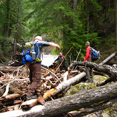
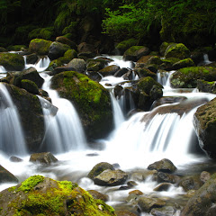
Rock of Ages is one of those hikes you hear about but can hardly find information on it. The main reason is because it’s a very difficult, unmaintained trail that is no longer on the maps. About two years ago, I attempted this hike without very good results. Despite the fact I was able to climb all the way to the plateau, at some point I lost the trail and ended up bushwhacking my way down. I recall it being a very long day were I thought I would be spending the night somewhere up there. Maybe that’s why it took me so long to re-visit this trail and do the loop I had intended back then. So better equipped with proper maps (not that I didn’t have them back then) and a GPS, I embarked on a mission to conquer the loop with a small group of brave hikers. Having hiked the Quartz Creek the day before, I opted for a later start considering the drive was quite short to his trailhead. We started up on the Horsetail trail and very soon, after passing a couple of switchbacks we got to the famous tree with roots that resemble a small staircase. We climbed those three or four steps and found the uphill trail just behind it. The climb was quick and steep with numerous switchbacks and going over loose grounds, exactly as I remembered it. Not long after we came to our first fork that most people ignore and just continue up. Knowing better, we turned left and followed a faint path to the Arch, one of the highlights of this hike. The Arch is just a rock outcrop with outstanding views of the Gorge. Right in the middle of it, there’s a small arch (big enough for two or three people to sit under it) that formed by years and years of wind erosion. From that vantage point, not only you can see the eastern side of the Columbia River Gorge but also the cliffs and peaks on the Oregon side. After a short brake, we climbed down and went back to the fork to resume our climb towards the Devil’s backbone. Although most of the trail is covered, it travels on a ridge where you can easily make the steep cliffs on both sides. After some more switchbacks, we came up next to a rock wall that can be climbed or walked around. That wall is actually the beginning of the Devil’s Backbone, a bare rocky ridge with steep drop offs on both sides. Definitely not for the faint of heart and not the best place to be in a storm. We found another group having lunch at that spot so we stopped for a couple of minutes before continuing on. From there, the trail dives into the forest but it doesn’t level or go down. By that point, we still had about 2/3 of the elevation to gain. From there to the plateau, the hike was pretty similar to other steep hikes in the gorge like Rudolph Spur or Ruckel Ridge. Then, all of a sudden, the trail level a bit and we got in a foggy forest. I started having some déjà-vu moments as I recognized some of the views I saw two years ago as I was getting lost. This time, without snow on the ground, the footpath was easy to follow until we got to the Horsetail trail. Shortly after the turn, we came up to our first creek crossing. It was not a big thing but we still had to find a good spot to walk on rocks and logs to make it. Being a bit after noon, we stopped on the other side of the creek for lunch while we watched the water rush thru rocks and logs. From there, we continued meandering thru a lush forest and crossed two or three more creeks on the way. We knew from several reports that the last creek, the Oneonta Creek, was running pretty high making that last crossing a bit of a challenge. A friend even sent me an email indicating they had flagged the best crossing point when they did it. As we continued traversing, we turned in towards a canyon and started descending a bit into wet lands. At that point we could already hear the rushing water but only saw the creek when we got to it. Yes, it was running much higher than usual. The strange thing about this trail is that, if you look at the map, the trail crosses the creek, then loops back and crossed again on a wood bridge about a quarter of a mile downstream. A good friend told me he was able to bushwhack down and find the trail after the second bridge eliminating the need to cross the creek. My idea was to try the same thing but what I was not counting on was having mature Devil’s club all around. After a couple hundred yards of bushwhacking we decided it was better to just get our feet wet. Interestingly enough, the point where we ended up crossing ended up being much easier than the marked path on the trail. As we crossed the frigid waters, we only found a single knee deep pool that was easy to manage. Although weather forecast was not indicating it, it started raining the moment we got to the other side, so we quickly dried our feet, put on the shoes and continued hiking along the Oneonta Creek. After that, sun came back just in time for us to make a quick stop at triple falls to take a couple of pictures and continue down to Horsetail falls. In the end, we were able to complete the loop with no issues. To me, it felt more of an accomplishment as I had my previous experience in mind.


Interactive map

To see the full map, click Menu and select Full Screen. You can also click Terrain to change the map style

Quartz Creek, May 29th

Our original plan for Memorial Day weekend was to go backpacking somewhere. Originally we thought somewhere in the Olympics but found out there’s too much snow up there. Then we looked south, same thing. Then, as a last resort we started looking closer to home and it occurred to me to backpack the Quartz Creek trail which I hiked last year. Unluckily, weather was not looking good for the weekend so we had to cancel that plan as well. From the three days, Sunday was looking to be the better one so we decided to go to Quartz Creek anyway and do as much as we could. We ended up doing pretty much the same route I did last time with the addition of a side trip to go check out the Lower Snagtooth Fall. We settled up for an early start so we were at the trailhead at around 9AM. On the way there, we noticed the Lewis River running pretty high (there were flood warnings all over Oregon and Washington). The first part of the hike, all the way to Straight Creek was easy going as we walked thru dense old growth red cedar forests. On the way there, we crossed the bridge over Platinum Creek. Last year, when I did this hike, the creek was almost dry. This time though, with all the snow melt, it was running pretty high. That made me start thinking about the couple of creek crossings we had ahead. Then we got to Straight Creek and noticed it was running very high. Crossing it would have been a bit of a challenge so we bushwhacked our way upstream to a big pile of logs and found a way to cross on them. Behind those logs there’s a nice waterfall were last year we took a group photo. This time, the water was high enough that the little dry area was completely submerged. After that little adventure, we started with the hard part of the hike. From Straight Creek on, there’s a lot of blowdown so, not only finding the trail is a bit of challenge but also you need to climb over or go under a lot of trees. In most of the pictures, you’ll notice that we are walking on trees, not on a trail. Snagtooth Creek looked a lot different than what I recalled. Last year, it was a tiny creek that we could easily cross using a couple of rocks. Not this time. We explored a bit upstream looking for a crossing option but did not find any so we stopped for lunch and then headed downstream. We found two good options, one was a very large tree at a steep angle that crossed the whole thing and the other was a couple of logs, one sitting on top of the other that offered equal opportunity to cross. A bit of a bushwhack later, we were back on trail. Shortly after that we started finding snow so once we got to the fork with the trail that goes to Quartz Creek Ridge, we took it and got to the same campsite where I returned last year. It was not as scenic this time but still usable. We talked about continuing on which was very uncertain or, head back and do some exploration. Since we didn’t want to go too far, we opted for the second option and explore a side trail we saw right after crossing Snagtooth. So we got back and took the side trail which ended up being just an animal path. Soon we found ourselves bushwhacking but opted to continue as we could see, far in the distance and hiding in the trees, a large waterfall. We found a path that took us thru a little gorge and a huge log that crossed from one side to the other. From there, I little walk upstream until we got a partial view of a huge waterfall. It was a good payoff for the effort. Then, it was time to head back thru our grueling exercise. As last time, it was a fantastic trip but I still need to backpack in the area!


You can check the pictures here

Interactive map

To see the full map, click Menu and select Full Screen. You can also click Terrain to change the map style

Elk Mountain Loop, May 21st

Located in the Tillamook Forest, Elk Mountain is one of the peaks you can visit. Although the views from up there are quite fantastic and different than the views you get from any place in the cascades, most people do it as a training hike in preparation for longer and steeper climbs in the summer. This trail can be done in conjunction with the King’s Mountain trail forming a grueling loop with lots of ups and downs or the shorter, less traveled version coming back down on the Elk Creek trail. In the past I have done Elk as an up and down only and also the traverse. This time we did the Elk Creek trail to check it out. So we got to the trailhead and I did my normal pre-hike speech explaining what we were doing and what to expect. I did note that one of the hikers in the group showed up in jeans, cotton t-shirt and dressy shoes. I told him that I was concerned about it because I knew how steep this trail is and not having proper shoes was going to be a problem. After a bit of debate, he said he was going to be ok… I was still worried as I though he didn’t know what he was getting into. So we got to the trailhead, looked up, and started climbing. Contrary to most trails that have an approach before you start climbing, this trail shoots straight up, there’s no warming up or getting into it. Just to give you an idea, the total elevation gain of this 8 mile loop is 2350 feet, the summit is at 2000 feet which you climb in 1.3 miles! On the way up, there are several viewpoints that overlook the Wilson River Valley and the highway as you leave it far below. When we got to the first viewpoint, our friend in jeans was panting really bad that had to sit down for a while and rest. About a minute after he started vomiting and my guess is that he was overheating. We waited for a while until he got his colors back and then with Pat he went back down to the car while the rest of us continued on our adventure. After about an hour of huffing and puffing we made the summit just in time to see dark clouds moving in. We opted for a short stop for lunch and then continued on the back side of the mountain where you scramble your way down just to climb back on the next ridge. We did several times until we reached the fork with the Elk Creek Road (an old and abandoned logging road). From there we turned right and started descending towards Elk Creek and soon found ourselves on one foot of snow. This section of the trail is very obscure and dense making it completely different from the ridge walk we had just come from. Shortly after, we found the second fork with the road where we turned right again. As we continued descending, we got closer to Elk Creek which has seen a fair share of destruction. Most of the upper section of the creek is almost covered with downed trees and remnants of old floods. Once bellow a thousand feet or so, the scenery changed a bit and opened up to nicer views of the creek. At some point, almost at the end of our hike, I saw a nice little waterfall and being adventurous as I am, I bushwhacked to it to take a picture. I can tell you I was not expecting the rocks to be as slippery as they were. As soon as I stepped on one rock, I slid sideways, hit my head on a log and landed on my but, in the water… I guess that should teach me a lesson. I did get the picture though.


Interactive map

To see the full map, click Menu and select Full Screen. You can also click Terrain to change the map style