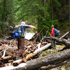
Our original plan for Memorial Day weekend was to go backpacking somewhere. Originally we thought somewhere in the Olympics but found out there’s too much snow up there. Then we looked south, same thing. Then, as a last resort we started looking closer to home and it occurred to me to backpack the Quartz Creek trail which I hiked last year. Unluckily, weather was not looking good for the weekend so we had to cancel that plan as well. From the three days, Sunday was looking to be the better one so we decided to go to Quartz Creek anyway and do as much as we could. We ended up doing pretty much the same route I did last time with the addition of a side trip to go check out the Lower Snagtooth Fall. We settled up for an early start so we were at the trailhead at around 9AM. On the way there, we noticed the Lewis River running pretty high (there were flood warnings all over Oregon and Washington). The first part of the hike, all the way to Straight Creek was easy going as we walked thru dense old growth red cedar forests. On the way there, we crossed the bridge over Platinum Creek. Last year, when I did this hike, the creek was almost dry. This time though, with all the snow melt, it was running pretty high. That made me start thinking about the couple of creek crossings we had ahead. Then we got to Straight Creek and noticed it was running very high. Crossing it would have been a bit of a challenge so we bushwhacked our way upstream to a big pile of logs and found a way to cross on them. Behind those logs there’s a nice waterfall were last year we took a group photo. This time, the water was high enough that the little dry area was completely submerged. After that little adventure, we started with the hard part of the hike. From Straight Creek on, there’s a lot of blowdown so, not only finding the trail is a bit of challenge but also you need to climb over or go under a lot of trees. In most of the pictures, you’ll notice that we are walking on trees, not on a trail. Snagtooth Creek looked a lot different than what I recalled. Last year, it was a tiny creek that we could easily cross using a couple of rocks. Not this time. We explored a bit upstream looking for a crossing option but did not find any so we stopped for lunch and then headed downstream. We found two good options, one was a very large tree at a steep angle that crossed the whole thing and the other was a couple of logs, one sitting on top of the other that offered equal opportunity to cross. A bit of a bushwhack later, we were back on trail. Shortly after that we started finding snow so once we got to the fork with the trail that goes to Quartz Creek Ridge, we took it and got to the same campsite where I returned last year. It was not as scenic this time but still usable. We talked about continuing on which was very uncertain or, head back and do some exploration. Since we didn’t want to go too far, we opted for the second option and explore a side trail we saw right after crossing Snagtooth. So we got back and took the side trail which ended up being just an animal path. Soon we found ourselves bushwhacking but opted to continue as we could see, far in the distance and hiding in the trees, a large waterfall. We found a path that took us thru a little gorge and a huge log that crossed from one side to the other. From there, I little walk upstream until we got a partial view of a huge waterfall. It was a good payoff for the effort. Then, it was time to head back thru our grueling exercise. As last time, it was a fantastic trip but I still need to backpack in the area!
You can check the pictures here
Interactive map
To see the full map, click Menu and select Full Screen. You can also click Terrain to change the map style
No comments:
Post a Comment