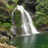
The Siouxon Creek is located on the Washington side just south of St Helens. This Creek offers a couple of trails, the lower and known and the north or upper which is far less visited and known. Doing a bit of research, I found that the access roads for both of these where blocked due to a land slide in forest road 54. That almost made me cancel the idea of going this hike. Still, going to “Black Hole” falls had some attraction to it so I dug a bit more info and found that there was another road on the north side of the Siouxon Block that gave access to the trail I had in mind. Just in case that road was blocked as well, I had a plan B to due the same trail but in reverse from the Mt Mitchell trail head. In the end, the road was closed so we had to go with plan B. Probably all this gibberish I just explained doesn’t mean a thing to you but, it helps me picture the fact that this trail is not very well known. So after a long drive, we finally got to the Mt Mitchell trail head and started our hike up. I’ve done Mt Mitchell in the past and know it offers great views that I still have to enjoy. This time was no different as it was cloudy and foggy. About a mile and a half in, we took the detour that would take us to our destination. The first portion was normal as we crossed a very dense forest which suddenly disappeared behind us when we started crossing a huge clear-cut. Unlike other clear cuts, this has actually grown some new plants and it was covered by what I believe to be Death Camas. The hike continued passing numerous forested areas and other sections of the clear cut until we reached an old logging road where we stopped for break and eat something. It was quite strange that, although the map indicates the trail is open for bicycles, horses and hikers, it didn’t seem to clean. We were in for a big surprise, as a Kim described the hike; it was like a 12 mile obstacle course from that point on. Although we were mostly going downhill, we had to bushwhack our way through some heavy brushes and downed trees until we got to the forest. Thinking that once on the cover of big trees it would be easier, it actually turned for the worse. I can safely say that you couldn’t do more than 100 feet without having to go over a tree or branch. In the pictures you’ll see what I mean as there is a sequence showing just that. Later we finally got to the Siouxon Creek which was surprising. Most creeks have a bed of loose rocks and gravel, this one, is just one big rock with water flowing over it. That makes the water incredibly clear with small falls all around as water finds its way downstream. To pass the creek we had to use the remains of a very old bridge that is about to fall. After that, it was more of the obstacle course towards the falls. I thought that being so secret, we would have to find our way thru the forest but we wee surprised to find a rather large sign indicating the route to the Black Hole. Yes, the hike was brutal but the payoff was incredible. I don’t think I can find words to describe the beauty of this water fall that is secluded and cut in the rocks. You’ll se I took several pictures (I actually posted about a third of the pictures I took) just trying to capture the colors and the water. The return was pretty much the same trail, so we went uphill through our obstacle course all the way to the car. This was an amazing hike although I have to say that I’m a bit disappointed for the way I found the trail. I guess not having access prevents any work party from getting there, but for the state it’s in, I would say it just has been forgotten.


2 comments:
Thanks for trip report. I was hoping to get to the Siouxon Creek trailhead from the east, knowing that 54 is closed coming from the west. Are you familiar with an eastern approach to that trailhead, not counting the access from Rd 58?
No, I'm not familiar with the Eastern Approach to the trail, but the Washington DNR website has tons of information and maps
Post a Comment