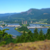
This hike is considered as one of the hardest hikes in the Columbia River Gorge. Part of it is because the ridge is very steep and part because in some section you can barely identify the trail. This day though, there was a third factor that made it even more difficult, heat! Ruckel Ridge is located just east of Eagle Creek, in fact, not only you part in the same place but you have views of the Creek all the way up until you reach Benson Plateau. The first portion of the climb goes thru numerous switchbacks deep in the forest until you reach the ridge with the first view point (The first couple of pictures from this hike are from that viewpoint). From there on, as you climb up on the ridge, you come out of the forest in several places with more views of the Eagle Creek valley and Bonneville Dam down bellow. After the second viewpoint and less than halfway up, we were already in the 80s so we knew we still had a long, hard hike ahead of us. The hike up continued pretty much the same with deep forests and open viewpoints until you get to the catwalk. This section is a rocky ridge that you have to cross before continuing on the last portion of the climb before reaching Benson Plateau. In most hikes like this, it’s sometimes difficult to know when you have reached the top. This was not the case in this hike. Once you reach Benson Plateau, even if you don’t have a map, you are pretty sure you are there as it’s completely flat. From there, the trail heads East thru the forest and descends a bit towards the creek. It was a very nice surprise to find snow in the creek and a much cooler temperature which made it perfect for our well deserved lunch stop. After resting for almost an hour while we enjoyed lunch and a bit of sun, we continued our journey toward the Ruckel Creek trail. Once there, descending is quite fast as you loose much of the elevation in a very short section. As with the Ruckel Ridge trail, this trail also goes thru some deep forested areas and some very open meadows. Vegetation is a bit different though as this side of the creek is far more humid that the ridge. After walking for a while, the trail opens up to a big meadow that had some wildflowers but was not very nice to walk on. With the intense sun shining on the hill, passing thru the meadow seemed more like torture than enjoyment. That was clearly market by a lot of sweating even though we were going downhill! After a while we got back in the forest (and a nicer temperature) and started heading towards the river quickly before hitting some switchbacks. On several occasions we came to corners with great view of the eastern side of the Gorge and Bridge of the Gods. The hike continues down and passes thru a big rock slide where you can see a couple of Indian pits. These are holes in the ground lined with rocks that where used by Native Americans in their vision quests. Then we continued down until finally we got to the creek and then the parking lot. A very long day.
BTW, you’ll see that I included some TiltShift pictures in the set. This is a technique where you "bend" the lens of the camera to take the picture so the subject looks like a miniature. Since I can't do that with my camera, I used some photo editing software to create the same effect. Pretty nice eh?

No comments:
Post a Comment