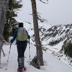
Newton Creek, Mar 2nd

Ah Newton Creek, the infamous Newton Creek that hasn’t allowed me to do a loop that I’ve been wanting to do in the winter for as long as two years now? Anyway, this is not yet another attempt at that loop. It’s another loop in the area that I did long time ago that is also very nice and includes some backcountry navigation. The route is pretty much the same as before heading towards Newton Creek but then, instead of crossing it, we followed a path uphill on the west side of the creek. This path meanders thru the forest with several openings offering clear views of Mt Hood (although it was hiding from us on this particular day). We followed this path to a point where you either veer of a bit and climb on a ridge or get deeper towards the Newton Creek canyon. Since I didn’t want to cross Newton, we opted for the first choice. And I have to say that is if probably the second best part of this loop. There’s no actual route but you are following the spine of a ridge with deep valleys on both sides. To your right is Newton Creek and to your left is Clark Creek. This ridge tops of at some point where you leave the forest behind and are welcomed by great vistas. Trying to avoid crossing a creek, we continued up until we found a covered spot over Clark Creek to cross and then do the hard climb up towards a parallel ridge on the west slope. From there you can see some of the lift lines in Mt Hood Meadows and several ski tracks left behind by some valiant backcountry skiers… or just lost skiers. Then came the best part of this route, going down on a ridgeline with clear views to the south that, on clear days, includes Mt Jefferson and Three Sister. Eventually the trail crosses the Newton Cree trail which you can’t miss if you are going down. Despite the fact that we didn’t get to enjoy a clear blue sky day, we certainly enjoyed the workout, the views and the route


Interactive map

To see the full map, click Menu and select Full Screen. You can also click Terrain to change the map style
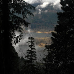
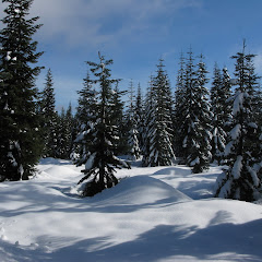
Nesmith Point, Feb 16th

So the weather was not looking very good for the weekend but we still needed to get out and do some distance and elevation. After considering several possible choices, Val and I picked up Nesmith Point in the Gorge. Nesmith is one of those trails that goes constantly up following a mostly forested path. Along the trail there are a handful of viewpoints that open towards the Gorge but as you’ll see in the pictures, we were already at cloud level so visibility was almost zero. Still, it was a good day to get out in the company of some old friends. We didn’t get wet but we did get a bit cold up there.


Interactive map

To see the full map, click Menu and select Full Screen. You can also click Terrain to change the map style

Worm Flows, Feb 10th

If I tell you that this route also starts from the Marble Mountain Sno-Park, you’ll start thinking that this is my new favorite place to go snowshoeing. You may actually be right or at least, it’s nice to explore a new area for a change right. So having done Chocolate falls and June Lake, the remaining loop I had to try was the Worm Flows. Originally I wanted to combine this with June Lake but I haven’t found yet a way to connect the two. This loop is a bit east of the June Lake trail and traverses an area that was pretty much created by flowing lava. I haven’t been here in the summer but supposedly, the entire hill is a lava flow that formed the wall where the water fall to June Lake comes from. Being a nice, warm day, Val and I decided to try it out by ourselves. Also, after navigating and leading some hikes, I needed a rest so I even left the GPS at home and navigated the old way… with map and compass. Is not that this area is too difficult, but you just need to make sure you’re turning where you need to. The first part was the usual forest walk heading towards the June Lake trailhead but at that point, instead of turning left, we continued straight. Soon we reached a stream big enough not to be covered in snow but narrow enough for us to jump to the other side. This was actually fortunate as we did not see any tracks after the creek leaving the entire area to ourselves. I can almost say it was a bit disappointing that most of the loop traverses new forests with limited views of St Helens or the surroundings. There are not many signs that you are walking over a lava bed. That said, we had solitude, incredibly nice weather and a lovely day.

Barlow Butte, Feb 3rd

This is definitely one of my favorite’s places to go snowshoeing. You might remember that I tried this route clockwise several times without being able to find a way to come down Barlow Butte. Finally, about a year ago (or more) I tried the loop but going counterclockwise on a low snow day. That day we were able to find a route and complete that elusive circuit I wanted to do. Better yet, I was able to map it so I could do it again. This time that was my intention but weather was not cooperating much. The day was gray and cold and dark. Yet we were able to find our way to the butte albeit not the normal way. At some point we veered farther north than intended to so we ended up going straight up on the north face of the frozen ridge. It was a bit exhilarating as the slopes were completely frozen. It made the whole thing feel like a true mountaineering experience. The weirdest thing was that the slope was not a big sheet of ice but rather a slope covered with small ice pellets. At points it felt as we were going up a scree slope. Once we reached the Butte, we were able to find our way, the normal way, and continue on to the south side. Incredibly enough, that side looked much better as we could see clearly all the way to Jefferson under a cloud ceiling. The rest of the loop continued as usual navigating on the ridge and then finding our way down to the Barlow Ridge road.


Interactive map

To see the full map, click Menu and select Full Screen. You can also click Terrain to change the map style
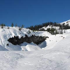
Chocolate Falls, Jan 19th

After doing June Lake, I realized there are a lot of trails and routes that start from the Marble Mountain Sno-Park. One of those is Chocolate Falls which I had read about before. As a hike it didn’t interest me that much because it was not very long and by the description, perhaps not that impressive either. The name comes from the fact thatthis is a small creek that comes from the top of Saint Helens picking up minerals and dirt. Once it reaches the rock wall, the water looks brown like chocolate. The part that hadn’t occurred to me, was this route could be done in winter. So I got there, started my slow ascend towards the waterfall and soon realized that this trail is also the winter climbing route to Saint Helens. Yes, there were a lot of people heading up. I also saw a couple of big groups doing some rescue training which was cool. What wasn’t very cool (and I didn’t know) is that it seems that the creek freezes in winter so the waterfall is dry. Still the route offered some really nice views of Saint Helens and the south cascades. Training to make the route a bit more interesting, I did a bit of backcountry going over the moguls on the lava field. It was quite eerie as you saw rocks and little crevices and cracks in the snow. It was a bit of a guessing game trying to find a safe route thru that stuff. Once on the other side, I continued to June Lake for a bit to complete the loop.


Interactive map

To see the full map, click Menu and select Full Screen. You can also click Terrain to change the map style