Mt Adams climb, Jul 22nd and 23rd

Hard to imagine that last time I climbed Mt Adams was 6 years ago! It was certainly time to head back up there again. Part of the reason I hadn’t done is because last couple of years, conditions have not been right and a big fire that went thru the cold springs campground where the trailhead is located at. This year, after a winter with above average snow levels, was looking like perfect conditions so I pasted in the calendar and of we went.


Day 1: Cold Springs to Lunch Counter

On our way to the trailhead we had to do the usual stop at the ranger station to get climbing permits. There we learned about the hordes of people going up the mountain. Apparently, they had about 300 self-issued permits overnight plus about 100 they had filled out that morning. That got me a bit worried about being able to find campsite at lunch counter. There are a lot of sites but they are still limited. We that in mind I wanted to get up there quickly, not rushed but quick. With permits in hand we drove to the trailhead which was, as I was recalling, rough ride. The campground is completely changed. I do remember some shade and sites where people would camp the night and just climb for the day. No is all exposed and dusty and barely a place to set up a tent. Even if you did, you would be covered in dust in about 10 minutes. Aside from that, there were cars parked down the road for quite a while. Lots of people on the mountain! So, we started the trail and right from the beginning, since there’s no tree cover now, it got hot. Luckily we were heading up so we knew we would be hitting snow patches that would provide some level of coolness. We got lots of beautiful flowers on the way and soon were hiking on snow. Rather than taking the winter route, we did a slight variation of the summer route which goes over the Crescent Glacier. The route was easy to follow as you had always people in front or behind you. Some puffy clouds started passing by but weather was pretty good. We finally made it to Lunch Counter in the early afternoon and were able to secure the three sites we needed. Interestingly enough, there were a lot of empty sites so I’m not sure how that worked. Either way, we set up camp and rested for the rest of the afternoon. I can’t say that all of us felt stellar. Either the altitude or just being plain tired got to us. Pete commented that he didn’t recall this being so hard while I was a bit dizzy and recovering. We didn’t find running water so part of the afternoon was spent melting snow for cooking and drinking. Later that day we enjoyed a magnificent sunset and then an incredible starry night. Temperature wasn’t that low that night and wind kept very calm so I was able to get out in the middle of the night for some night photos of the milky way. I was able to stay out for about half an hour until my toes started to freeze.


Day 2: Lunch Counter to summit and back to Cold Springs

We woke up early on Sunday with the plan of starting to climb at around 7AM. As we were getting ready, packing and having breakfast, we enjoyed a nice sunrise with light hitting the side of the mountain and casting a shadow all the way to the horizon.


I still find it incredible how the shadow projects all the way into the sky. It’s a pretty amazing sight. Right before starting I turned and looked towards the climbing route and could see a line of people going uphill like a line of ants. There was a lot of people on the mountain. Our march was slow and steady and like that, we reached Pikers Peak, the false summit, at bit after 9AM. Wind was blowing a bit harder at that point so we ate a bar, put on some new layers and then continued up on our last push towards the summit. About 40 minutes later, we finally made it to the top with a bright sunny and spectacular day. There was a considerable number of people to the point that there was a line to get on top of the chalet to take the famous victory photo.
Then it was time for the fun part, glissading down the mountain. The first chute we took brought us down from the summit to the saddle towards Pikers Peak. The snow was soft but still slippery enough to slide with no effort. It was going to be a fun slide. At Pikers, we had three chutes to choose from. I waited for a bit as I wanted space in front of me to go fast. Once I saw I had a clear line, I literally thru myself down the mountain. In the past, when I’ve done this I had to stop several times and restart because I would get out of the chute or loose control. With softer snow, I was well in the chute with no need to stop. I reached Lunch Counter in about 20 minutes after a single run where my GPS told me I had come at about 15 miles an hour. It was a blast and I almost wanted to go up to it again! Since we all got down relatively quick, we took our time to repack, eat and rest a bit. I took my rain pants off and notices I had trashed them so if there was more glissading, I needed an alternative solution. I remembered that I always carry a heavy plastic bag in my pack so I took it out and put it in my pocket just in case. On the way down we found more chutes that we used. They were not as fast as the upper chutes but good enough to glissade with your pack and save you from walking down the mountain. We did that for quite a while until our packs, pants and boots were completely drenched. Finally, we reached the trail were more glissading was just not possible so we hiked from there. Since we had saved quite some distance we reached the trailhead at a very reasonable hour with plenty of time to stop for lunch and head back home. I believe this marks my fifth climb and only the second with perfect views but I must say that mountain is getting harder to climb.

You can see the rest of the pictures here

Interactive map

To see the full map, click here

Bluegrass Ridge, Jul 9th

Another route from my long to-do list, and this one had been there for quite a while. The Blue Grass ridge is one of those trails that is slowly disappearing and being forgotten. I’m not sure if it’s because a big portion of it was burned in 2006 or lack of funding yet, due to the fire, you now get some pretty amazing views from that trail. The other challenge about this route is distance. Even though it could be combined to make a loop using the Elk Meadows trail, it’s better to do a car shuttle between the trailhead and the Tamanawas trailhead. So, when I saw Zach’s post to lead this hike I jumped right in. AS things go, everyone bailed so in the end it was just him and me for this hike – no car shuttle, but we decided to test our luck and try to catch a ride back to the trailhead from Tamanawas Falls. So off we went. There are several places when you can get on this trail but the most convenient perhaps is the Elk Meadows trailhead just before Hood River Meadows. The first portion is a very well know area where you can cross with lots of other hikes and families heading to or coming back from Newton Creek (also a great winter route). After crossing the creek people thin out as the trail quickly gains elevation thru several switchbacks that take you up to Elk Meadows. Once there, you find yourself at a four-way junction where any choice good if you had to pick one. You could head to Gnarl Ridge, continue exploring Elk Meadows or the lesser known trail to Elk Mountain which is the one we took. The top of Elk doesn’t offer much of a view but a short trail continues down a ridge to a much better viewpoint where Mt Jefferson appears to the South. The views east are a bit harder to identify as you look at Robin hood Creek drainage. After a short stop for pictures and food, we retraced our steps back to Elk Mountain and got on the Bluegrass Ridge trail. The trail thins out and disappears quickly under your feet so you need to find your way. It’s not that hard as you are following the ridge line, still, there’s plenty of logs and rocks to go around. Aside from the magnificent view of Mt Hood to the left, we had a compete wildflower covered ground. It made a great contrast with the white, dead wood all around. We hiked for miles enjoying both until we reached a rocky outcrop that opened views to the north with Mt Adams and Rainier almost aligned. Right in that area, we crossed a small creek completely covered with Columbines.
 I’ve never seen so many in just one spot, the whole hillside was painted red. From there we negotiated our way down on an even more faint trail until we reached the Elk Meadows trail where we turned right. This trail took us to the junction with the Tamanawas Falls trail which is not part of the route but a side trip. I’ve seen this waterfall in the winter but never in the summer so it was time for a side trip. WE headed up and found a big rock slide that fell on the trail making a bit hard to go thru. Several people got to that point and turned around as they couldn’t figure a way around the huge boulders. We climbed around and got back on the trail to the waterfall where we found a family taking pictures behind the waterfall. We didn’t go there but took a break at the base enjoying the views.


Several pictures after, we resumed our hike retracing our steps to the junction and continuing the Tamanawas trail to the trailhead. Along the way we met a couple that was also hiking out and asked them for a ride which they gave us to the trailhead. To celebrate our accomplishment, we made a stop at Solstice for a well-deserved pizza and beer. What a day.

You can see the rest of the pictures here

Interactive map

To see the full map, click here

The Thumb, Jul 4th

After the wonderful Oregon Coast Backpack, we still had an extra day. With the choice of either coming back home early or doing another hike we all voted for the later. At first we thought about doing Cascade Head but quickly found that there was no access to the trailhead. Then I recalled a hike I did earlier this year to the Thumb so I proposed that to the rest of the group. None of the had done it so I quickly downloaded my tracks and took them there. The hike itself and the views were fantastic as with the first time I did with the bonus of wild flowers. Right from the start we got to several displays that almost hurt the eye. The other encounter was with a deer that, same as last time, followed us for a bit before taking of and disappearing into the forest. It was a very rewarding short hike to finish a long weekend with good friends… and with plenty of time to get back home a relax before the work week started.


You can see the rest of the pictures here

Interactive map

To see the full map, click here

OCT – Bandon to Port Orford, Jul 1st to Jul 3rd

The Oregon Coast trail connects trails and roads to create a route that traverses the entire Oregon Coast. This section, from Bandon to Port Orford in the southern end of the state is remote with few access points so most of the hike must be done on wet sand. That might sound from the start as a very nice proposition but it’s not as easy as you may think. Walking on sand, all day long, not only can be tiring but it can play hard on your feet. Add to this that the Oregon coast is generally on the colder side and windy and you have a challenge. Just to top all this, there are a couple of creek crossings that can be tricky depending on time of day. Then why you do it you ask? Because the southern Oregon coast offers some pretty dramatic scenery.


Day 1: Bandon to the BLM Primitive Campsite
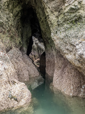

One of the challenges of this trail is that there’s no overnight parking at the starting point. To solve that, we left our car at the City Offices along highway 101. Our plan was to hike south for three days to Port Orford and then take a bus back to the car. This plan changed the very last day. Right from the parking area, we started questioning the forecasters who had said it was going to be cloudy in the morning but mid-morning to noon it was going to clear up and be sunny. It wasn’t looking like that, especially with the fine mist we had. After a short walk on the road, we got to the staircase that gave us access to the beach. Right from thee we could see the scenery would be dramatic with all the rock formation and haystacks. Most rocks look to be volcanic in origin but that’s just a guess given by how jagged they are. Maybe they are not and its simple erosion. Still it looked like rubbing yourself against any of the rocks would create serious damage to your skin. The contrast with the gray sky gave it an even better look as the almost seemed to come to life. Around one of the many rock formation, we found a small flooded cave that had an opening on the other side and a rock in the middle. We didn’t go in to explore even though we were twitching about it. Then we left the rocks behind and walk for miles on a flat beach with crushing waves on one side and tall grasses on the other. About half way down we had our first river crossing across the New River. It wasn’t too deep or challenging, just cold. For most of the day we saw almost no one else. Part of the reason you need to stay on wet sand is because the grassy areas is where the Western Snowy Plover nests this time of year. Aside from the notices posted by the Forest Service, the whole area is cordoned out to prevent access. There’s only one spot open in the middle where the BLM campsite is, our destination for the day. When we got there, we found the campsite empty and were quick to grab our spots. We were lucky as three or four other groups got there later and had to find sites further in close to the river. That night we ended up going to bed early and quickly after dinner as the weather never improved and was rather cold.

 Day 2: BLM Primitive Campsite to Cape Blanco State Park

The second day started gray again but cleared quickly so we got the full blue skies but not the scorching sun. It was still windy and the temperature on the cooler side. After breakfast and packing our gear, we got back on the wet sand and continued our march south. The beat did not change much for several miles although we could see (and knew) there was a head towards the end of our day and we would be hiking in the forest for a bit. Just after passing Floras Lake we found the post indicating we had to get off the sand and into the forest. I was very happy about this because my feet were hurting bad. I had made the wrong choice of bringing very flat river shoes so my feet where in pain most of the time. I though changing terrain from soft sand to harder dirt was going to be good for my achy feet. It wasn’t that much but it certainly helped.
At first we walked thru a tunnel of trees that looked like an image from a Walt Disney movie but son we got deeper into the forest and gained a bit of elevation. Aside from the green forest and ferns, there were tons of Rocky Mountain Iris flowers. I took several pictures but there were so many that I decided to just hike and enjoy them along the path. I must say this is one of my favorite flowers, not only because if its color but also the shape. The trail took us down to a small creek where we crossed a smelly campsite (there was skunk cabbage everywhere) before climbing back up to the head. We saw a faint trail going to the edge of the cliff and decided to go explore as it looked interesting. I’m very glad we did as we got to a view point overlooking a rock formation with a huge arch right below us. I started looking for a path to go down an explore but didn’t see one. I think the only way to get there is as an out and back from the beach before you veer off to the forest, but that will be for another day.


Further down we found another viewpoint with views towards Blacklock Point. From the first we saw there was a big flat area ahead so we made the plan to find a way to get there and stop for lunch. We didn’t have to explore that much as the trail took us straight to that point. The sun was scorching so we had to find a little shade to have lunch but the views were incredible. From that viewpoint, aside from the amazing flower displays, we could see most of Blacklock Point which would be our next stop. Looking down towards the rocks we saw something unexpected from that point. Almost at water level, next to the rocks and half buried were a set of rail tracks. As far as we knew there were never train in this area. Later we would learn that this point has always been known for having minerals so back in the day, here were prospectors mining around along the coast so they probably put those rails to haul dirt and rocks around. After our short lunch break, we continued and got to the trail that connect to Blacklock Point. This is a very well visited area so we found a lot of people there. We made another stop, dropped our packs and walk to the very point of the rocks where we took some pictures. I kept looking south towards a black rock that, from the distance, looked like the batman mask. It was quite interesting.
Back on the beach we continued south and got to out next challenge, crossing the Sixes River. This one was not too deep but it was running fast. Then the beach got small and we saw the lighthouse in the distance. We knew we were not that far from our destination for the day. Once we climbed the side of the hill we headed to the lighthouse thinking we would cam around that area. WE later found we were wrong so just by chance and because we got there, we visited the lighthouse. Finding the campground took a little asking and a lot of walking on the road. This was not easy on my achy feet but the day was almost over. We finally made to the campground where we paid for our right to camp and found that showers were included. The campground host indicated were to find spots which we found easy. The problem was that we didn’t feel very comfortable because of a homeless guy camping, smoking and drinking right in the middle. With that, we continued to the horse area and since we found it empty we started to setup there. The ranger showed u quickly to tell us that was not going to work but when we explained the reason we understood. It seems that homeless guy frequents the campground and the complaint has been raised several times before. So, we found a flat spot under the trees and camped there for the night.

Day 3: Cape Blanco State Park to Port Orford


We woke up to wet tents. I can’t say I notice rain but I guess it did happen overnight. Still the day, as the previous day, started cloudy but soon cleared up and got pretty nice. Right after breakfast and packing we got back on the trail and shortly after ended up at a view point. That when we got our trail magic. AS we were enjoying the views, a couple popped up from the other end with two dogs. We started talking and found they were doing the same route as we were but in opposite direction. We later thought that must have been painful as they were going against the wind but read on. They told us their plan was to come out the 4th and take a bus south. They didn’t know there wasn’t going to be bus service the 4th (that was the reason we were coming out the third day). So, then the woman asked us if we were willing to get their car and drive it to Bandon and drop it off there. It didn’t take half a second to say yes so they gave us the key to their Subaru and explained where it was. We exchanged phone numbers and told then where we would leave the keys and with that, we continued our path. I must say at this point that I do admire that trusting mentality. I don’t think I’m that far as to give my car keys to a complete stranger, but that’s trail magic at its best. After the encounter, we descended to the beach and continued south until we got to Elk Creek, the last challenge of the route. We quickly found the river was way too deep to cross safely. So, we started exploring upriver to see if we could find a viable spot. Pete tested several places and got water up to his waist so we decided to drop our packs and wait for the tide to lower so we could get across. We must have waited one or two hours before it got doable even though we still got wet up to our waists.What came after that was torture though. Before the river crossing we notice the wind picking up sand and blowing it across the surface. It looked almost magical. But after the crossing the was no cover of any kind so the wind was a lot stronger. The sand was also coarser on the side but still flying. It took only one wind gust to realize we needed to put on some clothes. The sand was flying so fast that it felt like we were being sand blasted. The only way to protect yourself was to wear long pants and long sleeves which we did quickly. 


That lasted for the entire length of the trail until we found what we thought would be our exit point. It wasn’t. After we didn’t find the car, we realized we hadn’t gone far enough on the beach. Instead of going back, we looked at a map and ended up walking on paved roads to the parking area where we found the expecting Subaru. I think I started this hike with an expectation of it being more like the Olympic Coast I did several years ago but it was not. This was more a walk on the beach but with its good share of challenges. 

You can see the rest of the pictures here

Interactive map

To see the full map, click here

Horseshoe Ridge loop, Jun 24

Since with a group of friends we were planning on doing the Timberline trail over the 4th of July weekend, I decided to lead a hike up in the area to gauge snow levels. Looking at the list of hikes I’ve done, I also wanted to do good distance and elevation so I pickled the Horseshoe ridge. Not only this loop has the stats I was looking for it also has the possibility of some pretty spectacular flower displays if you catch it in time. With that in mind, we headed for the mountain. Right from the start we had very nice weather with a cool day and not too humid (which happened last time I was here making the hike difficult). Still, we knew it was going to get hot during the day. The first part was mostly flat in a nice forest until we got the bridge one of the affluent of the Sandy River and found ourselves with no bridge. Looking around we saw several promising logs so some in the group bushwhacked downstream to get on those while others decided to get their feet wet and cross safely to the other side. Once there we started our march up the ridge.Not long after that we found a deer carcass that wasn’t completely eaten by whatever killed it. We guessed it was probably a cougar but that was a clear indication that not too many people had been going over this trail. We sweated quite a bit as we gained elevation towards the view point. Once there we took a lunch break with the always amazing views of Mt Hood and the usual suspects towards the north.
By then the temperature had climbed almost at the same pace as we did so it was pretty hot. Then we resumed our route and things got complicated quickly. Since we turned to the shaded area of the trail we found snow on the ground and some heavily bent branches that made navigation a bit of a challenge. On several turns Zach found the trail to the side while I was looking the other way which was good. Mosquitoes were fierce in that area as well so between swatting them and getting branches off our faces it became a complete workout. We did find some pretty amazing avalanche lilies on the trail like we haven’t seen in a while so that was very nice. Even though we were heading down it got pretty tough at point but finally, after a long while we finally descended enough to get out of the snow. Getting out of the snow and to lower elevation, also meant more heat. On that march, almost all of us ran out of water still with a couple of miles to go. We did pass a water source but didn’t stops as we all figured it wouldn’t take that long to get back to the car. It actually did so we were pretty dry by the end of the hike, but it was a good workout with some pretty nice rewards. Oh, and we figured there was too much snow to do the Timberline trail

You can see the rest of the pictures here

Interactive map

To see the full map, click here