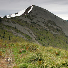

After a short lunch break, we continued our traverse by climbing down on the saddle that connects “Oh shit peak” with the ridge that goes to Silver Star. In this area, I had to navigate a bit as the trail was covered in snow. Still, I was able to reach my mark, the junction with the Bluff Mountain trail, with no problem. Once there, as I had planned, I consulted with everyone whether we were continuing as planned or not. We decided to go for it. Navigating the backside was actually easier, for the most part, than what I had expected. The trail followed a rocky ridge curving towards Silver Star. Not only the trail was very interesting to do but the views, despite the weather, were incredible. Nearing Silver Star, I lost the trail and started climbing a bit towards the peak, thinking that we could scramble up and make it. Just by luck, we found a rock arch on our path and were able to climb to it. It was a very interesting sight whether you were looking in, out or thru it. In the picture set, you’ll see one photo that looks like a crushed rock face that was taken in that spot. After looking around, we finally realized that there was no easy way to scramble up to the summit from there so we started climbing down and were able to make some faint tracks down below. After making the turn, we made our way and finally found the trail to the summit. Although we didn’t have a clear and crisp blue sky day, the views from the summit were very nice. We took a short break there before heading back down as we knew we still had a long way to go. We retraced our steps back thru the ridge all the way to the fork with the Starway trail where we re-checked our time and energy to continue. Everyone was remembering the arduous hike coming up so we all opted for trying the Bluff Mountain trail to where my car was parked. From our point of view, we could actually see most of the trail as it traversed around Little Baldy and Bluff Mountain. As we were hiking the views of the valleys to the north changed three times and the valley to the south did the same twice. Way back we could see Silver Star and almost the whole route we had made so far.

After passing Bluff Mountain we found considerable snow and lost the trail one more time. I navigated as good as I could but noticed, after a short while, that we were not on the right path. Not only were we heading south but we were actually gaining elevation. At some point we decided to turn around and hike back and take an alternate route to avoid the ridge we had started climbing. We could make the trail ahead of us so we just went straight to it. That ended up not being a great idea as we had to traverse a snow filled, rock slope. That took about an hour to sort but finally we made it to the trail. By then it was already starting to get dark, not because of nightfall but because there was some rain approaching. We hiked, and hiked and hiked snaking around small mountains and slowly descending, passed a couple of snow fields and finally saw the road up ahead. By then we were all hiking in auto mode. We made it to the road and then hike the extra mile back to the car just in time to avoid the rain and night fall. It was an epic hike, maybe more after I learned that there have been very few that have done this entire loop.
Interactive map
To see the full map, click Menu and select Full Screen. You can also click Terrain to change the map style
No comments:
Post a Comment