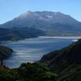
View from Independence Pass

From the pass, the trail continues gaining elevation as it circles around the eastern side of the lake. As you do that, the other volcanic peaks start to show up behind the ridges. On the other side of the ridge, what is known as Mt Margaret Backcountry also starts to appear. This is a deep basin with several lakes and incredible scenery. From different points along the ridge, you can get some views of Shovel Lake down below and the rocky ridges that circle the area. The only common scenery is the pattern that all the downed trees create. It was incredible to see areas that were devastated and how they have recovered to beautiful postcard scenery. Along the ridge, I got a nice view of a small valley along a creek that flows to Spirit Lake that’s a perfect example of this
Postcard scenery

Shortly after that view, I got to the fork with the Whittier Ridge Trail. From pictures and reports I’ve seen, this is the hardest part of the Mt Margaret Backcountry loop. The trail follows the rocky ridge which has been blown or eroded. I decided to take a quick jaunt to check it out. I guess I didn’t do the whole thing or didn’t reach the hard section although I can say that the trail is not for the faint of heart. It does follow a very narrow line on the side of the ridge with a very steep drop off to one side. After a while and seeing that time was running by, I turned around and got back to the Boundary Trail. From there I continued for a while until I found the side trail to the top of Mt Margaret. I got there just at the time I had set up to start hiking back but with that scenery, I had to sit and enjoy it for a while. The views from up there included Spirit Lake, a clear view of the Crater, St Helens Lake and the volcanic peaks. Then it was the hike back. Being a bit late, I had to hike a bit faster to get back to the car before dark. Oh what a day!
No comments:
Post a Comment