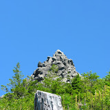
With a long weekend ahead of us, it was time for us to plan a long hike, that way, if we were in too much pain; we still had two days to rest after that. For this I had a couple of options with similar distances and elevation gain so I opted for Three Corner Rock in the Yacolt Burn State Forest in Washington. This peak has a three or four different approaches. One of them is short and not that difficult, two coming in from either side of the PCT and the approach from Stebbins Creek. To me, the Stebbins Creek looked like a better choice but that involved a hike of about 18 miles to get to the summit. So we met on a very hot Friday morning to drive to the trail head taking two cars. In the process we lost one so the group got initially divided. Once there, and after waiting for a couple of minutes, we decided to head out and maybe regroup later. The trail started with a short climb going around a small butte towards Stebbins Creek. Once we passed the butte, the trail continued on a steady ascend close to the creek until we got to some big rock formations. From that point, the trail was all switchbacks gaining a lot of elevation until we were high enough to pass a small creek. On the other side we had roughly the same amount of switchbacks going back down. By that time we had seen a couple of clearings were we could see Three Corner Rock in the distance. It was funny that in one of those turns, there was actually a sign that read “In the Distance”. The trail continued through a dense fern forest with some clearings. By the time we got to the point were we needed to cross Stebbins Creek it was already very hot so we took a long rest and just when we were about to continue, Greg (from the car we lost) arrived. The rest of the group was 10 to 15 minutes behind him so we decided to wait a little more to regroup. Once Chris, Valarie and Carol got to the creek, we continued through some more forest and steadily climbing until we got to a forest road that provides access to the easy hike. After crossing the road, the trail changed to a more open set of switchbacks with lower vegetation which made the last couple of miles to the top a daunting task. With the clear sky and full sun, we were literally cooking ourselves on our way to the summit. Once there though, after the short scramble on the rocks to get to the very top, besides being welcomed with sweeping 360 degree views, we had a nice, cool breeze. After a well deserved lunch and enjoying the sun and views, we started our way back down on the same trail. In the end we were very tired but the sense of accomplishment was great. Hiking for about 10 hours to cover 18 miles is not a walk in the park, but is definitely doable!


No comments:
Post a Comment