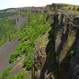
Coyote wall is a one of those places that was almost unknown a couple of years ago but has gotten a lot of attention recently. Part of that is because it offers some really splendid views of the Columbia River Gorge but also because there are numerous trails mostly used by mountain bikers. In the spring, as it happens with other trails in the area like Catherine Creek and Dog Mountain, Coyote wall gets filled with wild flowers that only make the views even more beautiful. I had planned this hike last year was not able to do it so finally, having a mild weekend I decided to take a group to explore the area. Once we got to the parking area, we started walking on an old road that goes around the end of the wall (although you can’t see it) and gets to the trail on the other side. Once on the trail, you start ascending gradually on numerous switchbacks that border a little stream with a couple of small waterfalls. On this climb, any time you look back, you are welcomed with a nice view of the Gorge that only gets better as you climb higher. At some point the trails crosses the stream and starts heading west to something that looks like a cliff. This border is the actual Coyote Wall, An incredibly huge basalt wall that curves towards the north-west. As you can imagine (and see in the pictures) views from this point are breathtaking and a bit scary, especially when you find a plaque commemorating a biker that missed a turn. The trail the takes you further up bordering the wall towards the power lines where we found a large area covered with wildflowers. The scenery was so pretty that we stayed there for a while taking pictures and even Shia decided to pose for everybody among the flowers. Although that area seemed to be the highest point of the wall, that was just perspective. From that point, we continued climbing even more bordering the wall and getting close to the precipice numerous times. Once we got to the top, we stopped for lunch at a spot that offered a bit of shadow and views of the Gorge. People that do the short version of this hike usually return the same way back to the parking lot but our plan was to do the big loop. After lunch, we continued on the trail which gets deep into the forest and passes through some private land. This portion of the trail was a bit disappointing as it didn’t offer many views until you start descending on the lower side and get a glimpse of the wall once again but from the bottom. On our way down, we took a short detour to check out and old wood shed and take some pictures before continuing down. Just before getting out, we saw some fast moving grey clouds that, in contrast with the wall, offered some nice picture opportunities.

No comments:
Post a Comment