Day 1: Twin Pillars South to Whistler Spring via Wildcat
 Very early on Saturday we woke up to a beautiful crisp day and after a quick breakfast and much stretching we hit the trail. The first portion of it, all the way to the fork with the Belknap Trail is pretty level as it follows the East Fork Mill Creek crossing it several times – we counted seven. Some of those are so close together that you could bushwhack from one to the next and save a couple of crossings. We did manage to do all crossings except the last one without taking our shoes off. The last one was a bit deeper and there was no big log nearby. The area as certainly a different kind of forest to what we’re used to though. Instead of the lush green, the forest in the area was very open with lots of gigantic Ponderosa Pines. The red bark with the green grasses and the blue sky made for some pretty interesting contrast.
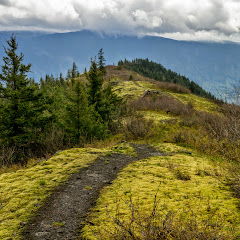
 We got to the Belknap Junction pretty quick and made the turn to start climbing. As you do, the Ponderosa forest is left behind and you get to a higher more exposed area where it’s easy to see the remnants of the 2000 fire that devastated most of the area. The other thing you find is more signs of cattle farming. Once the trail reaches the Wildcat Trail and turn on it, you follow a quasi-ridge with views of the Ochoco Mountains to the East and Desolation Canyon to the west. This trail can get pretty exposed and dusty in areas. At some point, with the heat and exposure we started running out of water but soon enough we reached the East Fork Mill Creek were we replenished and cooled down. From there, a short walk brought us to the upper end of the Wildcat trail at Whistler Springs. Kind of unexpecting it, this end if actually an unimproved campground just at the boundary of the wilderness. Certainly the big truck, camper and ATVs were a bit out of place. We followed the campground road to the end where we found a fence and a good water source. Further from there, we found a flat area where we decided to pitch our tent.

 Since it was still early for dinner and we had some energy left in us, we decided to go exploring a bit. One of things I had found in my research was a picture from Whistler Point, a small rock outcrop pretty close by. We followed very faint paths as much as we could but in the end, we bushwhacked our way to the top were I found the exact same picture. It was very well worth it. The top itself is covered with red rocks and some dried trees with white barks. All that beauty in the foreground has the Mill Creek Wilderness as a backdrop. From up there you can see the wildcat trail and the ridge it follows and Desolation Canyon.
We spent there enough time to suck all that scenery in before heading back down to camp and a well-deserved diner.
Day 2: Whistler Spring to Belknap Junction via Twin Pillars
We usually wake up and go for a walk before breakfast, that’s or thing when we’re backpacking. Unfortunately, here, there wasn’t anywhere to walk or go check out in the morning (unless we went back up to Whistler point). So after checking the area around us, we had breakfast, packed and left. We knew we had to backtrack a bit to get back on the road as you need to hike on Rd27 to close this loop. Before we got all the way up though, we found what looked to be the road to take. We followed it for a bit until it pretty much disappeared under brushes and fallen trees. By then we knew we were not on the right track. One option was to backtrack again and the other, was to just bushwhack north to find the road. We opted for option two which took us right back and eventually showed that there was a road at some point.
Once on the road we followed it pass Moccasin Prairie to Bingham Springs were we turn to an unimproved campground where the Twin Pillars north trailhead is.
 The campground was king of eerie as we found nobody there but a fire ring was still smoking. While putting it off with some water is when we noticed the fire extinguisher on the tree full of bullet holes and the leg of some animal hanging from it. Luckily we didn’t hear banjos. We crossed the campground and pretty soon were back on the trail.
We passed a planted forest full of smaller trees growing around fallen logs that looked like a giant game of sticks. A bit further scenery changed again when we reached the top end of desolation canyon.


Once you go around the pillars, the trail continued on a little ridge on the south side before it starts climbing down into the oven. As you loose elevation, you get deeper into the canyon with very little vegetation and still remnants of the fire. It’s hot and dusty but eventually you hear a creek, make a turn a quick downhill and you are back next to the South Fork of the Mill Creek. It didn’t take us long to find a good spot for our second night. After setting up camp, we spent some time refreshing ourselves in the creek and exploring around.
Day 3: Belknap Junction to Twin Pillars south trailhead
Last day we wanted to back in the car at a reasonable time for the drive home. Being about 3 miles and 7 creek crossings, we were able to do it pretty quickly while still enjoying, one more time, passing thru the Ponderosa Pine forest. Once out and on the road we got an extra bonus as we were able to admire the scenery that we didn’t see on the drive in including the Steins Pillar.
You can check the pictures here
Interactive map
To see the full map, click Menu and select Full Screen. You can also click Terrain to change the map style