Coldwater Lake from the trailhead

The first half of the hike was easy and fast as we were traveling on the north shore of the lake. From there we could see rocky peaks and ridges but no Mt St Helens even though we were very close to it. Once we got to the northeast end of the lake the real fun began as we started climbing alongside the Coldwater creek leaving the lake behind. It didn’t take long for the scenery to change completely from a very open basin with a sizeable lake to a narrow canyon with orange rock formations. Looking up towards the ridge, we could see the first signs that identify this area, dead trees. At some point the canyon opened up into a basin that, from our point of view looked to be mostly sand. The trail continued traversing one side of the hill giving some great views and gaining elevation towards a second basin a bit higher were we would find our first destination at Snow Lake. I had originally thought that we’d get some pretty descent views from this lake but I soon realized I read the map wrong. That didn’t mean that it was not beautiful or there weren’t any good views. Snow Lake is in a little basin surrounded by ridges that are covered with blown trees from the eruption of Mt St Helens. The interesting thing was to be able to see the combination of a new forest trying to grow after it was completely devastated.
Snow Lake and our first campsite on the opposite shore

With plenty of time, we ate, set up our tent and explored a bit around the lake. A bit later, as the sun started to go down so did the temperature. Not being able to build a fire, we opted for getting in bed early and recuperate for the next day. As it always happens, both Val and I had to take our turns to get out of the tent in the middle of the night. That part is not interesting but the fact that we had a full moon and it was illuminating the dead trees was almost magical. Not only the valley was completely lit but the trees were almost glowing white all around us. Unfortunately it was too cold to stay out or even thinking about taking a picture. Then, closer to dawn, we woke up to a weird animal call that seemed to near for comfort. At first we couldn’t make what it was but after a while we figured it was a male Elk nearby.
The next morning, it took us a while to get out of the tent. We were hoping for some early sun but it was clear that it was not going to happen. As we were making breakfast, we started taking down the tent and placing wet stuff were the sun would hit first with the hope we would get our dry before leaving the campsite
Early morning from Snow Lake

Then, the sun hit the valley and the day started. It felt almost like flipping a switch. Soon after that we were on the trail again doing a short climb towards a pass where the Whittier Ridge trail starts from. It was little winding trail thru the dead and new forest all the way up. Both Val and I were walking fast as we knew we had some spectacular views coming. And we were not disappointed. Right at the moment we got to the saddle our views changed into deep valleys and tall ridges with Shovel Lake below us and Mt Adams in the distance
Mt Adams from the saddle

From that saddle, the trail keeps pretty much flat with small ups and downs as it traverses several lakes. At times it was difficult to know which one was which or if you were still looking at the same lake you were looking five minutes before. Is not that there are way too many lakes; it’s the trail that snakes thru them changing your perspective all the time. First we descended walking on a rocky ridge with views of Shovel Lake below us. Up front the view of Panhandle Lake travels with you as you get closer to it and cross a creek that connect it with Shovel Lake. Then you are back in a brushy forest and another lake appears as you walk to and around it. In total the trail passes three lakes with at least three or four more than can be accessed from the main trail.
Twin Lakes

After Twin Lakes, the trail changes a bit as al lakes disappear for a while and the view towards the Grizzly Creek basin opens up. For miles and miles you can see blown trees from the eruption that gives you a hint of the destructive force of the volcano. At some point we passed the last lake of the day that was covered with dead wood to the point we thought of trying to cross it. Luckily we were not that close to the lake to try that one. Then we started gaining elevation again and I knew we were getting closer to Bear Pass. We passed several valleys before getting there but eventually we made the pass and turned to a complete new and incredible view.
View from Bear Pass

From this point on, the views of Mt St Helens right in front would follow us to the end of the trip. After a short stop for lunch at the saddle, we continued on towards Mt Margaret. This is the portion of the trail that I had done about 2 years ago that got this loop in my to-do list. As we walked I remembered my lone hike from way back then. For the rest of the afternoon we traversed the hills admiring the valleys around Sprit Lake and the fall colors on the trail. Later in the afternoon we passed the junction where the Whittier Ridge trail joins the Boundary Trail. At this hour, the pass was already in the shadows of Mt Margaret looming in front of us. We pushed on and hiked around the mountain until we got to a plateau where you can see a side trail to the top of Mt Margaret
Val near the trail to Mt Margaret

Once there, we dropped our packs to hike up to the summit of Mt Margaret. Is not a long hike but very rewarding as you can see Mt St Helens, spirit Lake and Lake Helens right in front of you but you can also see Mt Rainier to one side, Mt Adams behind you and all the way to Mt Hood, Jefferson and beyond. It truly feels like being on top of the world
Val on the summit of Mt Margaret

After coming down it was just a matter of getting to our next campsite not before getting water. We knew that there were not a lot of water sources on the trail from that point on and we had been told that our campsite, Dome Camp, didn’t have water. With that in mind, we continued hiking looking for any water source we could use to fill out and carry water to camp. On the way we found a small trickle of water coming from below an ice field that looked promising. Once there we filled bottles and bladders and a couple of water carriers so we would have enough for the night and the following day. Carrying that was the harder part though. From the creek to our camp we had a bit over a mile to go so Val took one bucket and I took the other one that we carried to Dome Camp. Finally, by the end of the afternoon, we got to Dome Camp only to find that another group had taken the best spots. After exploring around a bit, we found a couple of flat spots to set up that were not bad at all. That night, being tired and late, Val and divided the chores so while I was setting up camp, she was getting dinner ready. Our day ended with a very tasty meal watching the sunset
Dinner with a view

The following day we woke up to cool morning but not as bad as the previous one. The views of the crater from our tent were fantastic and it felt like we’d been backpacking for days. Val and I, as we always do, went for a short walk before breakfast. On that walk, we backtracked towards the trail, crossed it and climbed up a small butte that offered some impressive views of Spirit Lake and St Helens. The sun was hitting that side of the mountain already so we stayed there for a bit giving it time for the sun to hit where our tent was so it would warm up a bit for breakfast.
Morning view of St Helens

After breakfast we packed and rechecked how much water we had left. We didn’t have a lot and we didn’t know when or where w would find water. It was a bit preoccupying. We started on the trail still following the high ridge line over Spirit Lake and around the Dome, a huge boulder formation. As we hiked, Lake St Helens got closer and closer. From the ridge we were able to spot some elks grazing bellow us. Originally I had thought the trail would pass close to the Lake but that was not the case. The Lake is far below in a basin that would not be too easy to get to. It still looked doable but not in the window of time we had. As we continued and the sun progressed above us, the colors and shadows on the lake changed giving it almost a magical sense. I tried to take a short video but it didn’t come out good.
St Helens Lake

After passing the lake and watching a huge but unreachable water source, we got to the junction with the Coldwater Lake trail that we had to take back to our car. At that point we couldn’t even imagine how the trail could change. As soon as we turned around the ridge, all the green disappeared and we were in an eerie, dry and almost deserted area. Clearly the area that was directly hit by the volcano when it erupted. The only vegetation we saw was small huckleberry that, luckily for us, was ripe and ready to eat. That helped us a lot with the lack of water. For a while we traversed the hills with nothing but arid land around us. The trail took us around a peak with no name were only small vegetation survives. Still we couldn’t find any water.
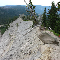
Almost around the peak

At some point we got to a ridge where the trail pretty much makes a u turn towards Coldwater Lake. From that point the views of the creek we followed as we were hiking in was visible far below us. The trail got a bit less interesting as we started losing elevation on the shaded side of the hill. The trail continued meandering thru patches of green vegetation and arid areas. Views were limited to the ridged across the valley where, somewhere down was Coldwater Lake. The other thing we noticed on this side is that part of the arid terrain is because the old forest, whatever was there before the blast, was actually logged. In contrast to the dead trees in the other side of the valley, on this side, the land was covered with stumps, not whole trees. As we lost elevation, the trail widened and actually became an old logging road. That section was very dusty which did not help much with the lack of water. Towards the end, we passed some old logging machinery that was blown with the eruption and left in place as a remainder of the devastating power of the volcano. Some would think nature made someone pay for logging the forest but I’ll leave that for another discussion.
Old machinery

By then we met some day hikers visiting the area so we knew we weren’t that far from the car. Thirsty and tired we continued down, got back on a deciduous forest that eventually took us all the way back to the parking lot. Our day ended with a race towards the closest place where we could find some drinkable water but still in awe about this wonderful experience. I think, from all the trails I’ve done, this one is the one that has the most variety
Link to album
You can check the pictures here
Interactive map
To see the full map, click Menu and select Full Screen. You can also click Terrain to change the map style