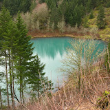
Fish Creek Mountain, Feb 6th

This was a weird outing. Fish Creek Mountain is located near the Clackamas River near Estacada. Due to its elevation, this is a trail that should be done more towards the summer when the snow has melted but since we had a window of really warm weather, I thought there was a good chance of doing this without snowshoes. The other detail is that this trail was almost abandoned some time ago as the original access road was washed out back in 1996 leaving the trailhead completely inaccessible. In recent years an alternate route was opened from the east side of the mountain mixing part of the old trail and a new section. So we got there and our first surprise was that the road was covered in snow so we were not able to drive to the actual trailhead. After leaving the car, we hiked on the road for a while until we found a fork going in the direction we wanted to go. According to my map, the trail was supposed to be there and run parallel to a very old logging road. With the snow and overgrown branches we missed the trail and took the road. That ended up being a bit of a torture with tons of ups and downs, slippery rocks, postholes and a lot of branches in the way. After bushwhacking for a while, we actually got to a second road that looked much cleaner and with no snow which we took. After walking for a while, we found a trail marker that was actually the trail that we had missed so by then, at least we knew we had taken the wrong way but we were back on track. At the end of the road we finally found the original trailhead which is still, amazingly, clearly marked. From there it was very easy following the trail up the ridge as it climbed. We found a bare spot on the ridge that on a good day must have some impressive views where we stopped for lunch. From there we continued to the summit and I must say that it was rather disappointing. The area is basically covered with tress so there are some limited views of the valley below but more than that, you can’t really tell that you are at the highest point. Also, since we were in some deep snow, we were not able to see any trail markers indicating we were at the actual summit. After walking around for a couple of minutes, we started heading back and took a detour to go check High Lake. This lake is tucked in the forest in what seems to be a shelf. It was complete covered in snow but judging by the scenery around us, it must be a little gem I the summer. Then it was the return back to the car, this time on the actual trail that proved to be easier and faster than the road we took on the way up.

News and changes to this… blog

So if you’ve noted the date of the posting and the date of the actual hike, you’ve noted that I’m running behind… that’s what work can do to you. But trust me; I’ve made a big effort on keeping you up to date with my adventures. In the works I have one more trip before I’ll be able to post the big trip, the 10 day backpack in Torres del Paine down in the Chilean Patagonia. On that trip I had the misfortune of seeing my camera die. Yes, of all places, it decided to die there. I was lucky that Jocelyn had a camera and was kind to let me use it for some pictures so not all is lost. With that trip posting I’m planning on adding some new stuff on my blog. One of those is a map of the area highlighting the trail or track. If all goes well and I have time, I’ll try to make a catalog with maps of all the hikes I’ve done in the past (wish me luck). Yes, it’s a big task and it will take a lot of time but all projects start like that, with an idea. The other thing I’m thinking of adding is a tab where I can talk about gear. At first it will be the gear I have, what I like or why I hate it but further along I might be able to talk about other stuff as well.
So there you go. Let me know if you like the idea or have any comments. I would love to hear those.

Wahkeena to Multnomah loop, Feb 5th

This is certainly a title you’ve seen before in my blog so yes, I did the loop one more time. As the days where getting closer for my backpacking trip to Patagonia, I needed to do some good distance and elevation gain carrying some weight. Rather than organizing my own hikes, I decided to tag along some other hikes that were being posted and use those for training. As always, this loop did not let us down. It was beautiful as always with a great group of friends. I’ll let the pictures do the talking now

Greenleaf Overlook, Jan 30th

This was a little hike I decided to do just to keep active. Since weather hasn’t been cooperating much I wanted something somewhat easy, in the forest but with potentially good views. This hike is on the north side of the Columbia River Gorge right across from Bonneville Dam. Being part of the PCT, you can actually make this hike as long as you want but for a short day hike, the Greenleaf Overlook is a great option. The first part of this hike goes gently uphill in a fern covered forest but then, after you pass the ridge and cross a forest road, you start descending to Gillette Lake. This little gem is so close and easy to get to that most people just ignore it. There are several camping options around it for easy overnight stays that are not that far from the highway (which can be a good and a bad thing). From thee we continued up thru the forest passing another little lake tucked within the trees. Soon we came to an open area with open vistas of the Columbia Gorge. At this point, the trail turns and starts heading away from the river and into the forest so there’s no more views for quite awhile. We decided to stop at that point and have lunch while we enjoyed the views. Unfortunately that didn’t last very long. The weather got worse and colder so we started heading back soon after. At least I was able to get some hiking done so it’s never bad.

Tanner Creek, Jan 29th

Tanner Creek, along with Tanner Butte is one of those trails that it’s being lost for lack of use. The primary reason is that we use to have a forest road to access the trailhead. That road was washed out some years ago and closed forever. So to do either of these hikes means that you have to start farther down and hike a good 3 or 4 miles just to get to the original trailhead and then start your adventure. You might recall that I did the Tanner Butte trail as a backpack with Mark and Brian in March last year. This hike was organized by Jessica and since I needed to start training for my trip to Patagonia, I decided to tag along with a big backpack filled with sand. We started from the Toothrock trailhead which offers easy access to the old road and a bit shorter distance. The first part of the hike was the expected uphill on the forest road. Besides passing the original washout that made them close the road, we passed two new washouts much bigger than the previous ones. One of them was big enough to almost cut the road completely. Further up we got to the Tanner Butte trail and continued on to the Tanner Creek which we found after a loop back turn with some nice views of the canyon ahead. Once there, the hike changed completely. What remains of the Tanner Creek trail is very little if any. We had to bushwhack part of the way, cross a couple of streams and find our way thru very old and almost disappeared signs. As some point Jessica was leading ahead and got to a point where she couldn’t make the trail any longer and didn’t think it was going to get any easier. At that point, she decided to turn around and head back. On our return I found an unreadable sign on a tree indicating probably the cutoff trail to Tanner Butte. The sign was not unreadable because it was old but because it was literally consumed by the tree.


We also found an old campsite with a much newer sign. I guess some people have used this campsite recently and are trying to keep it alive. Certainly it’s a place that can be explored on a longer backpacking trip. I also made a quick stop at one of the creeks that flows under the road for a couple of extra pictures. It was very nice getting out and definitely a good training hike still; it left us with a bit of a sour taste as most of it was on a forest road and not discovering some new path.

Devil’s Cauldron, Jan 23rd

Middle of the winter in Portland can mean a warm and beautiful day. When that happens, there’s nothing better than getting in your car and heading out to the coast for a little hike and magnificent views of the Pacific Ocean. My intention for this day was to go around Devil’s Cauldron and then track back, cross the highway and head up Neahkahnie Mountain. What made me change my mind was a low cloud hanging around the top of the mountain that would have obscured any possible views. It still ended up being a great day. We started from the Oswald West State Park following the trail to the beach where we could see some surfers enjoying the waves. From there, we hiked to the edge of the park were a hanging bridge gets you to the trail that stats climbing the head pretty fast in a dense coastal forest. On that trail we passed one tree that I’ve like. In the pictures you’ll see that the trunk is divided and lands on both sides of the trail. From the distance it looks like a dinosaur crossing the trail. Soon after we were up on the head with more than a couple of nice views of the ocean. After passing the second forested area we came to the meadow that sits around the Devil’s Cauldron. Most hikers go to the left where you end up at a view point with a fence that overlooks the cliff and the ocean. We, trying to experiment a bit, followed a very trail to the other side that climbed to the tree line on the other side. Right at the edge, we found a small flat area that had amazing views view of the ocean a couple hundred feet bellow and the cauldron to the back. Rather than stop there for a bit and then continue, we decided to stay there and spend a couple of hours relaxing in the sun and enjoying the views before heading back… and all this in the middle of winter!