Silver Star via Starway, May 16th

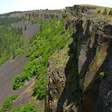
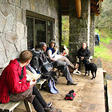
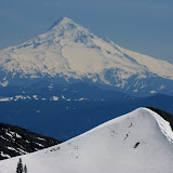
This is a hike that I did with Kristen and her boyfriend about a year and a half ago. Back then it was late in the summer on a vey hot day which made it really difficult to go beyond the first peak (which doesn’t have a name) towards Silver Star. Being a very nice hike, I organized a group to actually try to do the whole thing. Being spring we had a much nicer day with warm weather, clear blue skies and lots of snow. Originally I had about 11 people signed up for this event but only four girls showed up. I do have to give credit to them because the really pushed it al the way regardless of snow, steepness or weather. We started from the same point I did last time crossing the bridge and quickly following an old forest road that goes up the ridge. For a while, this trail takes you thru dense forest on a very steep incline until it reaches a section of second growth forest. From there, ascending is more gradual on a trail that starts disappearing. Once we got to the snow, we were pretty much on our own although we knew we had to follow the ridge and some trail markers to the first peak. The snow wasn’t bad at all, with the high temperatures we’ve been having, the snow was very compacted making it easy to navigate thru it. After a first short scramble, we got to a view point with the first clear views of Mt St Helens where we stop to take some pictures. From there, we had another scramble and a little bit of forest to go before getting to the first peak. We got there roughly at 1PM so it was perfect time to stop for lunch while enjoying the views around us. As you’ll see in the pictures, we were on top of a peak with 360 views. From there we could see the falls on Star Creek but more impressive, all the surrounding volcanoes in the Cascades. We could also see from there our intended destination, Silver Star. To continue there, we had to descend to a saddle that then climbs abruptly to a ridge before heading to the summit. Since this section of the mountain faces north, it doesn’t get a lot of sun so snow stays much longer. Still, we were able to reach the ridge on the other side after climbing a rather steep snow field. We did continue on the ridge for a bit until we saw that the path towards Silver Star was not very clear. Considering we had done a lot and it was getting late in the afternoon, we decided to call it and head back not without having some real fun. As you might imagine, we had to descend all those steep snow fields we climbed earlier. Instead of just walking down, we used our jackets and a plastic bag to slide all the way down. It ended up being so much fun that we actually climbed back up to do it again… several times! Once we got tired of it, we continued bushwhacking until we found our trail and back to the car. By that time we were already hungry so on the way home, as most of the time, we stopped to grab something to eat. The reason I’m mentioning it here is because we stopped at a burger place with the best service and food I’ve had in a long time (considering it was a fast food place).


Coyote Wall Hike, May 10th

Coyote wall is a one of those places that was almost unknown a couple of years ago but has gotten a lot of attention recently. Part of that is because it offers some really splendid views of the Columbia River Gorge but also because there are numerous trails mostly used by mountain bikers. In the spring, as it happens with other trails in the area like Catherine Creek and Dog Mountain, Coyote wall gets filled with wild flowers that only make the views even more beautiful. I had planned this hike last year was not able to do it so finally, having a mild weekend I decided to take a group to explore the area. Once we got to the parking area, we started walking on an old road that goes around the end of the wall (although you can’t see it) and gets to the trail on the other side. Once on the trail, you start ascending gradually on numerous switchbacks that border a little stream with a couple of small waterfalls. On this climb, any time you look back, you are welcomed with a nice view of the Gorge that only gets better as you climb higher. At some point the trails crosses the stream and starts heading west to something that looks like a cliff. This border is the actual Coyote Wall, An incredibly huge basalt wall that curves towards the north-west. As you can imagine (and see in the pictures) views from this point are breathtaking and a bit scary, especially when you find a plaque commemorating a biker that missed a turn. The trail the takes you further up bordering the wall towards the power lines where we found a large area covered with wildflowers. The scenery was so pretty that we stayed there for a while taking pictures and even Shia decided to pose for everybody among the flowers. Although that area seemed to be the highest point of the wall, that was just perspective. From that point, we continued climbing even more bordering the wall and getting close to the precipice numerous times. Once we got to the top, we stopped for lunch at a spot that offered a bit of shadow and views of the Gorge. People that do the short version of this hike usually return the same way back to the parking lot but our plan was to do the big loop. After lunch, we continued on the trail which gets deep into the forest and passes through some private land. This portion of the trail was a bit disappointing as it didn’t offer many views until you start descending on the lower side and get a glimpse of the wall once again but from the bottom. On our way down, we took a short detour to check out and old wood shed and take some pictures before continuing down. Just before getting out, we saw some fast moving grey clouds that, in contrast with the wall, offered some nice picture opportunities.

Nesika work trip, May 2nd

For a long time, Trails Club of Oregon had a rule that they did not allow dogs at Nesika lodge or the surrounding area. Recently, after arduous discussions, some members convinced the board to change that rule and at least allow people to bring dogs to the lodge but keep the out of the buildings. With this new rule, the problem is where do you sleep if you bring a dog. The available options are to bring a tent and camp somewhere nearby or sleep in the porch (as I did for this weekend). With this in mind, Linda and Lisa found an area close to the lodge where they could have a campsite for people with dogs so they invited us for a work weekend to build it. As always we met early in the morning and headed out to the Multnomah Falls trail head and hiked from there to the Lodge. Once there, we had a light lunch and went straight to work. During the afternoon, we cleared, leveled and marked four campsites and a central location with a nice fire pit. Not to tut our own horns but we did an amazing job and practically finished the campsite which we decided to name Camp Wuhpi. That night, after having a nice dinner and resting a bit, we went back with some dry firewood and made the first fire. Originally we had planned to work a bit more on Camp Wuhpi on Sunday morning before heading home but Linda wanted us to clean up a bit the trail to Franklin Ridge. So we took some tools and headed up cutting tress, trimming brushes and clearing the path on that trail all the way to the intersection where the trail ends. From there, we did a short hike back to the lodge where we had a nice lunch with all the left over, cleaned the lodge and hiked out. It was a great weekend with lots of work but not too many pictures.

Beacon Rock State Park Hike&Work Weekend, Apr 25th

This event was planned in conjunction with Ryan from the Washington Trails Association. WTA is an advocacy group that does mostly trail maintenance so they are constantly organizing work parties with volunteers to do trail work. For this particular weekend, being the first time with WTA, I decided to do a combination hike and work thing to make it more interesting for the group. Since WTA volunteer where working the whole weekend, they had a campground reserved for all. On Saturday, after meeting everybody we drove to the campground. Once there, we picked our spots to set up camp and leave our gear. Shortly after lunch, we went out on a hike towards Hardy Ridge. The first portion of this hike was on a forest road. Half way up we found the connector trail that WTA was working on and where we were going to be working on Sunday. From that point, we continued going up until we found the fork to the Hardy Ridge trail. Unfortunately the weather turned on us so the whole time during our hike we were covered in clouds and fog. The views you are supposed to get from the ridge were no there. Still it was a very nice hike and once we got back to camp, we met with the rest of the group. They had already started a fire and WTA was providing Hot Dogs and trimmings. We spent a long time talking and meeting the rest of the crew and then Ryan organized a couple of games for the group. On Sunday, we woke up early in the morning and had a good breakfast before Henry showed up and started his safety talk before hitting the trail. Once we got our green hardhats, we divided in groups and drove to the trail head, grabbed the tools and went to work. There we formed 3 or 4 teams and each was taking on a specific task. One group was farther ahead clearing the path and cutting some smaller trees. A couple of groups behind were removing a couple of tree stumps in the middle of the trail while others where just cleaning and I was working with Henry hand cutting to large trees that were in the middle. It was really an experience to see that there was almost nothing when we got there in the morning and in the afternoon there was already a clear trail for just a couple hundred yards. Obviously the work is not done, Ryan was commenting that the trail we were working on has to be multiuse (bike, hike or horseback ride) so they will probably be working all summer to get it done and we might post more of these working trips. For me, besides experiencing the change in the trail from morning to afternoon, working on the connector trail made me appreciate more all the trails we use every weekend that we take for granted. Making a new trail of just maintaining it so it’s usable requires a lot of work that often goes unnoticed.

Neahkahnie Mountain, Apr 19th

After doing Munra Point which was absolutely fantastic, both Li and I still had a bit of the need to do another peak. To change the scenery a bit and taking advantage of the extremely good weather, we decided to head out to the coast and hike up Neahkahnie Mountain from Oswald West State Park. The hike starts in a somewhat dense area going towards the coast and the veers off and starts climbing on a very dense forest. After a while, the trail reaches a meadow that opens up giving a view towards the viewpoint in from of the Devil’s Cauldron. We took a short detour to go check it out and enjoy the views. AS you’ll see in the pictures it was breathtaking. From that point, we hiked back towards the road, crossed it and started ascending towards the summit. The hike itself has a handful of switchbacks with great views towards the coast. On a hot day, you start feeling these switchbacks pretty soon. About half way in, we got back in the dense forest and much cooler temperatures. The forest in this part of the hike is primarily second growth with immense trees. The beauty is that the trail goes around and gives you a hint of the summit but you get the real view in the last couple of steps. Around that area, I found some pretty nice flowers which I believe to be shooting stars. We stayed on the summit for a while enjoying the view of the coast and then started our hike back. Almost at the end, Shia took an opportunity to refresh herself a bit, something that even to us felt really good.