Hike to Silver Star Mountain, June 29th

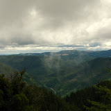
I have to start by saying the name of this hike is wrong. Not because that is not the name of the mountain we were trying to climb but because we got somewhere else. I though of changing it to the correct name but I couldn’t find it in my maps. Any way, when I decided to join Jason and Kristin on this hike, I though we were doing the normal and very well known trail that goes thru a rock arch and then to some old Indian burial pits. But no, Jason had a different plan. The idea was to take a north trail that should have taken us all the way to the summit of Silver Star Mountain. After a somewhat rough ride we got to the end of the road, next to a river (which I believe is the Star Creek). From that point we started and as soon as we crossed the bridge, we started ascending on a very steep trail. Under normal condition this would get you tired quickly, but if you add the hot and humid weather, well you get the picture. The trail itself follows an old logging road up the side of the mountain with limited views. The first portion of the trail is just undergrowth the covers pretty much everything. After a long while, we crossed to a section of the trail that opens up to a very dense forest. It doesn’t get any easier or less steep from here on though. There was on point in this section were you can get a glimpse of Mt Hood but this is just that, a glimpse of the view later on. We got to a point were de trail seemed to start descending a bit which was contrary to our heading, so at that point we went off the trail and up the mountain. For a while we did some bushwhacking until we got to the snow. Yes, snow, in June, with 90+ degree weather, there’s a picture to prove it. From that point on, we continued our hard climb with a nice view of St Helens and Rainier in the distance. Shortly after passing the snow, we finally made it to the summit. That’s when we realized we were not in Silver Star Mountain since we were looking at it right in front of us. Still, reaching this summit was not bad at all. We got to a small patch without snow, just wild flowers and 360 degree views. Sitting up there and being able to see St Helens, Rainier, Adams, Hood and Jefferson all at the same time is simply breathtaking. We also saw a couple of falls on the north side of Silver Star that were incredible. On the upper portion you can clearly see two, almost identical falls. The flow continues down where you can spot two or three more falls down below and then a very impressive water jump to a deep creek. After resting for a while and realizing that the weather was turning on us, we started our way down which was as treacherous as the way up. In the end, it was a very long and hard hike but very well worth it.

Hike to Elk Mountain, June 22nd

The original plan for this weekend was Cairn Basin up in Mt Hood but due to snow, again, I had to change my plans. I decided on a trail on the Oregon coast that looked really nice on paper. Don’t get me wrong, it is, but it’s also the hardest that I have ever done. With the information I had, I knew there where a couple of possibilities all starting from the same trail head. One was going up on the Elk Mountain Trail and coming back down on the Elk Creek trail. The other, much larger option was to continue to Kings Mountain and back down to the Wilson River Trail. All these trails are in a wilderness area in the Tillamook County. At the end, I started on the Elk Mountain trail and waited until I got to the intersection to make a decision whether to continue to Kings Mountain or go back down on the Elk Creek trail. The trail started in a very dense forest with a steep climb that I thought wouldn’t last long. I was very wrong. The first part of the trail, a bit over a mile and a half, is a very steep ascending from 900’ to about 2700’. Views are incredible all the way thru until you get to a false summit with a sign that says 2500’. From there the trail descends abruptly only to come back up to the real summit at which point you tongue is reaching you belly. Even with a cloudy day, as you’ll see in the pictures, it was a fantastic view. From the Summit I still had to go 2 miles to reach the intersection where I could decide to continue or go back. I though that since I was at the summit, there was no more going up… wrong again. That couples of miles are like a roller coaster, it goes up and down abruptly. Most of this portion of the trail you find yourself either jumping a couple of feet down or climbing a rock that required bringing your knees to your chest. I felt really out of shape when a group of three trail runners passed me running in the opposite direction wearing their tight Spandex. Finally I made it to the intersection and stopped for lunch. A couple of hikers I meet in the way recommended me not doing Kings because it was already late to complete the loop from where I was, so I took the Elk Creek trail back. The hike back was not as difficult although equally steep. The trail follows and old logging road next to the creek al the way down back to the parking lot. I found a lot of washed out portions and the creek itself had lot debris, trees and rocks. It was very interesting and a great hike, although I’m still feeling the consequences.

Hike to Hidden Falls, Jun 14th

This is one of the best hikes I’ve done so far. I found the information on this area by accident and decided to take a group there. I knew from the beginning it was going to be a long and hard hike with a lot of bushwhacking. The reason is that trails do not appear in any map. Not only that, some of the falls in the area, don’t appear in maps or satellite images either. The idea was to do a full loop towards hidden falls then go around the power lines and descend on Archer Mountain. Originally I had planned to go see Cable Falls that doesn’t appear in maps either but that would have taken much longer. Getting to the trailhead was easy and we were greeted by a deer close by. After getting thru a portion of the forest road and enjoying the views of the valley and the tall wall with the cross, we went down to a river and then started climbing up on the other side. All this area was a very dense forest making it very difficult to pass. A bit later we found a wall of loose rocks that had to climb and then continue on a section on our hands and knees. Eventually we got to a really nice view point. From there we headed north towards the power lines and found an old logging road that took us there. The views from up there were truly amazing, but at that point we still had a bit to go to reach hidden falls. When we got there we couldn’t see much but could hear the fall right in front of us. After going around we found the crack between the rocks were the fall is. This was truly unbelievable. The fall itself is probably 100’ but you can’t see the bottom. Not only that, you can go down the crack and get really close to it. AS you’ll see in the photos, sunshine was shinning thru illuminating the fall while we were there. From there we continued on the service road for a while until we had to veer of towards the river. We did a bit of bushwhacking until we found the edge of the canyon. A bit after that we got a nice view of Archer falls. This fall was also amazing falling over 200’ down to the valley. There’s the possibility to go down to the base of this fall, but that takes a bit of skill and time. From there we continued and eventually found the ridge trail that took us down to a huge rock formation right on top of the cross. After enjoying the views and resting for a bit, we continued on the trail that descended quite abruptly back to the car. Truly an amazing hike that left some unexplored areas for future hikes.

Hike to Larch Mountain, Jun 7th

Larch Mountain, at a bit over 4000’, is the highest peak in the Columbia River Gorge area. It was jus a matter of time until we tried to do this hike. Unluckily, we found some snow on the top and were unable to pass beyond a certain point. Still it was a great hike. Sean and I combined people from Meetin and MeetUp and were also joined by four people from the Mazamas. The first portion of this hike is the Multnomah trail which is the same we do every time we go to Nesika. After passing the rough and hard first section, we continued our way up passing some open areas with rocks as well as dense forests. On the way down, just to add a couple of extra miles to make up for the summit we didn’t reach, we took the Wahkeenah loop. There wasn’t as much water as there was a couple of weeks ago, still, the stream and falls were beautiful as always. In total we did about 12 miles which was not bad at all.

Walk with Dogs at Dog Heaven, June 1st

On Sunday I took a group of people and dogs to dog heaven for yet another fun day. We tried to do the same route we did last time when we went all the way to the river but found that half or more of the park was completely flooded and there was no access to the river on any of the three or four trails we tried. That wasn’t a problem for the dogs though. They were very happy to go try every single pond, puddle, flooded area or anything with water. It was a lot of fun seeing Vento and Shia running after a toys and logs while Dusty waited for them to get back and jump all over them. Roscoe and Chewbacca also had a lot of fun running unleashed in grass much taller than them while Maddy was trying to find her way. Even with a little drizzle, it was a nice couple of hours in the park.

Hike to Hamilton Mountain, May 31st

Another great hike that I’ve done before. Hamilton Mountain is a big boulder ridge on the Washington side right behind Beacon Rock State Park. I organized this hike not only because it has a lot to offer but also to train a bit for the Adams adventure in July. The forecast did call for clouds but there was no mention of rain. Just when we were starting our hike, we got a bit of a drizzle that disappeared shortly after. Rodney falls looked really nice with all the water coming down from the mountain and the falls between the rocks were just as amazing. Weather got a bit better when we got to the ridge where we went out to take some pictures. Although this is not the highest point of this hike, certainly is the one with the better views. We then continued our ascend thru countless switchbacks until we got to the summit. We made a stop at the summit for lunch and to enjoy the views. After that, we headed back doing the longer, easier trail. Wonderful day.